ATLAS of ANTIENT GEOGRAPHY by SAMUEL BUTLER 1843John McInnis Auctioneers,LLC4.6(502)See Sold PriceFeb 24, 2024
18TH C. ANTIQUE MAP: FRENCH & INDIAN WAR, FRAMEDThomaston Place Auction Galleries4.4(386)See Sold PriceFeb 24, 2024
Rand McNally Railroad Map Cabinet w/ 21 Railroad MapsRail & Road Auctions4.6(165)See Sold PriceMar 08, 2024
Keith Haring - Ink on New York Map, Best Buddies, Inscribed, Signed, and DatedSapphire Auction Gallery4(67)See Sold PriceMar 02, 2024
LATE 17TH C. FRENCH MAP OF THE NEW WORLD BY ALEXIS-HUBERT JAILLOT (1632-1712)Thomaston Place Auction Galleries4.4(386)See Sold PriceFeb 24, 2024
Central Railroad of New Jersey Map of Sandy Hook Route-ca. 1903JM Hobby Supply and Railroad Artifact Auctions4.4(126)See Sold PriceFeb 24, 2024
Lot of Six Mixed Atlas Box Cars-HO Scale-New in BoxJM Hobby Supply and Railroad Artifact Auctions4.4(126)See Sold PriceFeb 25, 2024
Rand McNally/Santa Fe Railroad Map of Iowa-1912JM Hobby Supply and Railroad Artifact Auctions4.4(126)See Sold PriceFeb 24, 2024
NICOLAES VISSCHER (NETHERLANDS, 1618-1709) MAP OF THE NEW WORLDThomaston Place Auction Galleries4.4(386)See Sold PriceFeb 24, 2024
17TH C. WORLD MAP BY NICOLAES VISSCHER (NETHERLANDS, 1618-1709)Thomaston Place Auction Galleries4.4(386)See Sold PriceFeb 24, 2024
Lot of Six Mixed Atlas Cabooses-HO Scale-New in BoxJM Hobby Supply and Railroad Artifact Auctions4.4(126)See Sold PriceFeb 25, 2024
Sold1862 Johnson Map of Florida -- Johnson's FloridaTitle: 1862 Johnson Map of Florida -- Johnson's Florida Cartographer: Johnson & Browning Year/Place: 1862, New York City Size: 12 x 15.3 in. Description: This is an excellent Johnson map of Florida, sSee Sold Price
1862 Johnson Map of Florida -- Johnson's FloridaTitle: 1862 Johnson Map of Florida -- Johnson's Florida Date: 1862, New York City Cartographer: Johnson & Browning Size: 12 x 15.3 in. Additional Information: This is an excellent Johnson map of FloriSee Sold Price
1862 Johnson Map of Florida -- Johnson's FloridaTitle: 1862 Johnson Map of Florida -- Johnson's Florida Cartographer: Johnson & Browning Date: 1862, New York City Size: 12 x 15.3 in. Additional Information: This is an excellent Johnson map of FloriSee Sold Price
1862 Johnson Map of Florida -- Johnson's FloridaTitle/Content of Map: 1862 Johnson Map of Florida -- Johnson's Florida Date: 1862, New York City Cartographer: Johnson & Browning Size: 12 x 15.3 in. This is an excellent Johnson map of Florida, showiSee Sold Price
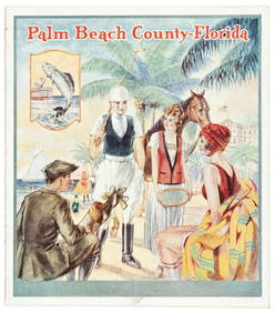
SoldJohnson’s 1862 map of Florida with wide marginsScarce map offers a wonderful snapshot of this secessionist state shortly following the outbreak of the American Civil War. Sharp example of the first Johnson & Ward map of Florida. The Johnson FamilySee Sold Price
Johnson: Antique Map of Florida, 1862Johnson’s 1862 map of Florida with wide margins. Scarce map offers a wonderful snapshot of this secessionist state shortly following the outbreak of the American Civil War. Sharp example of the firsSee Sold Price
Sold1863 Johnson Map of Florida -- Johnson's FloridaTitle/Content of Map: 1863 Johnson Map of Florida -- Johnson's Florida Date: 1863, New York CityCartographer: Johnson & Ward Size: 12 x 15.3 in. A nice Johnson map of Florida, showing only 37 countiesSee Sold Price
1863 Johnson Map of Florida -- Johnson's FloridaReserve Reduced! Title/Content of Map: 1863 Johnson Map of Florida -- Johnson's Florida Date: 1863, New York City Cartographer: Johnson & Ward Size: 12 x 15.3 in. A nice Johnson map of Florida, showinSee Sold Price
1863 Johnson Map of Florida -- Johnson's FloridaTitle: 1863 Johnson Map of Florida -- Johnson's Florida Cartographer: Johnson and Ward Year / Place: 1863, New York Map Dimension (in.): 12.1 X 15 in. This is an excellent map of Florida, showing onlySee Sold Price
Sold1865 Johnson Map of Florida -- Johnson's FloridaTitle/Content of Map: 1865 Johnson Map of Florida -- Johnson's Florida Cartographer: Johnson and Ward Year/Place: 1865, New York Size: 12.5 X 15.5 in. This is an excellent map of Florida, showing onlySee Sold Price
1863 Johnson Map of Florida -- Johnson's FloridaReserve Reduced! Title/Content of Map: 1863 Johnson Map of Florida -- Johnson's Florida Date: 1863, New York City Cartographer: Johnson & Ward Size: 12 x 15.3 in. A nice Johnson map of Florida, showinSee Sold Price
1863 Johnson Map of Florida -- Johnson's FloridaTitle/Content of Map: 1863 Johnson Map of Florida -- Johnson's Florida Date: 1863, New York City Cartographer: Johnson & Ward Size: 12 x 15.3 in. A nice Johnson map of Florida, showing only 37 countieSee Sold Price
SoldJohnson Map of Florida, 18631863 Johnson Map of Florida -- Johnson's Florida. A nice Johnson map of Florida, showing only 37 counties in the state. The majority of development is in the north with no mention of St. Petersburg orSee Sold Price
SoldJohnson: Antique Map of Florida, 1864Map: 1864 Johnson Map of Florida -- Johnson's Florida Cartographer: A Johnson Year / Place: 1864, New York City Map Dimensions: 12 x 15.3 in. Condition: Very Good. Vivid colors. Slight age toning throSee Sold Price
SoldJohnson: Antique Map of Florida, 1864Title/Content of Map: 1864 Johnson Map of Florida -- Johnson's Florida Date Printed: 1864, New York City Cartographer: Johnson & Ward Size: 12 x 15.3 in. A nice Johnson map of Florida, showing only 37See Sold Price
Johnson: Antique Map of Florida, 1864Title/Content of Map: 1864 Johnson Map of Florida -- Johnson's Florida Date Printed: 1864, New York City Cartographer: Johnson & Ward Size: 12 x 15.3 in. A nice Johnson map of Florida, showing only 37See Sold Price
Sold1863 JOHNSON'S FLORIDA MAP FRAMED HAND COLOREDAntique Florida map created and published by Alvin Jewett Johnson in Johnson's Family Atlas. The map is hand colored, and uses the colors to distinguish the various counties. It makesreferences to AmeSee Sold Price
SoldMAP: Johnsons Florida, 1863Maps“Johnson’s Florida” Dated 1863 1863, “Johnson’s Florida,” published by Johnson and Ward, New York, Choice Extremely Fine. From the Johnson’s Family Atlas,See Sold Price
Johnson's Florida | Johnson's West IndiesTitle/Content of Map: Johnson's Florida | Johnson's West Indies Cartographer: JOHNSON, ALVIN JEWETT Date: 1864 Publisher: JOHNSON AND WARD Size: 21.75Height - 15.5Width Inset plan of the Keys and BermSee Sold Price
SoldJOHNSON'S MAP OF FLORIDA CIRCA 1863 PUBLISHED BYJOHNSON'S MAP OF FLORIDA CIRCA 1863 PUBLISHED BY JOHNSON AND WARD, HAND COLORED, VERY GOOD CONDITION, FRAMED SIZE 22"W X 18"H, SKU896.10See Sold Price
Sold19th C. Johnsons Map of Florida19th C. Johnsons map of Florida, published by A.J. Johnson, New York in 1863,12.5"H. x 16"W., 19.25" x 22.5"H. overall.See Sold Price
SoldJOHNSON'S MAP OF FLORIDA CIRCA 1863 PUBLISHED BYJOHNSON'S MAP OF FLORIDA CIRCA 1863 PUBLISHED BY JOHNSON AND WARD, HAND COLORED, VERY GOOD CONDITION, FRAMED SIZE 22"W X 18"H, SKU896.10See Sold Price
Sold19TH C. ANTIQUE JOHNSON'S MAP OF FLORIDAMid to late 19th C. 23x20 inches framed. Image size 15x12 inches. Antique map of the state of Florida published by A.J. Johnson, New York with vivid color. Very good condition.See Sold Price
1787 George Washington American Florida Shakespeare Tobacco Gentlemans MagazineSchilb Antiquarian Rare Books4.8(421)See Sold PriceMar 31, 2024
1872 Holy BIBLE & Hitchcock Analysis Gruden Concordance Theology MAPS Holy LandSchilb Antiquarian Rare Books4.8(421)See Sold PriceMar 31, 2024
1862 $5 Florida Tallahassee Obsolete Currency Cotton Haxby#FLCR14 PMG VF35Mynt Auctions4.6(680)See Sold PriceFeb 26, 2024
ANDREW RAYMOND JANSON OIL ON BOARD ADIRONDACKSCharleston Estate Services Ltd.4.5(58)See Sold PriceMar 03, 2024
JAWS RIDE AT UNIVERSAL STUDIOS FLORIDA - Set of Ride DocumentsPropstore4.2(6)See Sold PriceMar 14, 2024
Johnson's Africa. Colonies & tribes. Liberia Nile Delta Cape Colony 1866 mapJasper524.5(9.8k)See Sold PriceFeb 28, 2024
Wicker Chairs Photograph by Nels JohnsonRapid Estate Liquidators and Auction Gallery4.5(1.1k)See Sold PriceFeb 24, 2024
Vintage Rare Orlando Florida Boardwalk Baseball Souvenir - Fridge Magnet - Pens - Park MapRapid Estate Liquidators and Auction Gallery4.5(1.1k)See Sold PriceMar 03, 2024