ATLAS of ANTIENT GEOGRAPHY by SAMUEL BUTLER 1843John McInnis Auctioneers,LLC4.6(502)See Sold PriceFeb 24, 2024
18TH C. ANTIQUE MAP: FRENCH & INDIAN WAR, FRAMEDThomaston Place Auction Galleries4.4(386)See Sold PriceFeb 24, 2024
Rand McNally Railroad Map Cabinet w/ 21 Railroad MapsRail & Road Auctions4.6(165)See Sold PriceMar 08, 2024
Keith Haring - Ink on New York Map, Best Buddies, Inscribed, Signed, and DatedSapphire Auction Gallery4(67)See Sold PriceMar 02, 2024
LATE 17TH C. FRENCH MAP OF THE NEW WORLD BY ALEXIS-HUBERT JAILLOT (1632-1712)Thomaston Place Auction Galleries4.4(386)See Sold PriceFeb 24, 2024
Central Railroad of New Jersey Map of Sandy Hook Route-ca. 1903JM Hobby Supply and Railroad Artifact Auctions4.4(126)See Sold PriceFeb 24, 2024
Lot of Six Mixed Atlas Box Cars-HO Scale-New in BoxJM Hobby Supply and Railroad Artifact Auctions4.4(126)See Sold PriceFeb 25, 2024
Rand McNally/Santa Fe Railroad Map of Iowa-1912JM Hobby Supply and Railroad Artifact Auctions4.4(126)See Sold PriceFeb 24, 2024
NICOLAES VISSCHER (NETHERLANDS, 1618-1709) MAP OF THE NEW WORLDThomaston Place Auction Galleries4.4(386)See Sold PriceFeb 24, 2024
17TH C. WORLD MAP BY NICOLAES VISSCHER (NETHERLANDS, 1618-1709)Thomaston Place Auction Galleries4.4(386)See Sold PriceFeb 24, 2024
Lot of Six Mixed Atlas Cabooses-HO Scale-New in BoxJM Hobby Supply and Railroad Artifact Auctions4.4(126)See Sold PriceFeb 25, 2024
1859 Map of New York StateAuthor: Johnson Title: 1859 Map of New York State Medium: Ink on paper Dimensions: 26"X18" Map of New York state dated 1859. Engraved by A.J. Johnson. Published by Johnson and Ward in New York. This iSee Sold Price
SoldTHREE STICK BAROMETERS; two by Henry J. Green, BrooklynCOLLECTION OF WORLD AND OTHER MAPS; including: Crane's Political Map of the World; The State of New York, J. H. French, 1860; Mitchell's New York, 1859; Denoyer-Geppert The World, 1927; Eastern and WeSee Sold Price
Sold[Texas Map][Texas Map], "Colton's New Map of the State of Texas Compiled from De Cordova's Large Map", published by G.W. and C.B. Colton, New York, 1859, hand-colored lithograph, 16 1/2 in. x 25 in., framedSee Sold Price
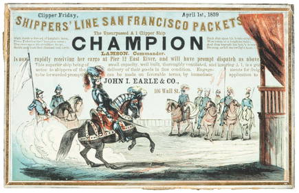
SoldButterfield's US & Mexico with map 1860Heading: Author: Butterfield, Carlos Title: United States and Mexican Mail Steamship Line and Statistics of Mexico by Carlos Butterfield, Washington, December, 1859. Place Published: New York PublishSee Sold Price
SoldColton.Map of the United StatesColton (J.H., publisher) Colton's Map of the United States,The Canadas &c., engraved map, original outline hand-colouring, 695 x 860mm., New York, Johnson & Brownrigg, 1859 § Wyld (JaSee Sold Price
SoldAntique Hand Colored Engraved Map NEW YORK STATE SmithDetails: This nicely hand-colored engraved map of New York State was designed by J. Calvin Smith and published by J. Disturnell circa 1852. Featuring insets of New York City and the St. Lawrence RiveSee Sold Price
SoldJohnson's New York Maps [New York State, NYC]Two Johnson's New York Maps, one of New York City and Brooklyn, the other of New York State. Alvin Jewett Johnson Cartographer. Published by A. J. Johnson, New York. Stamped 'Entered according to ActSee Sold Price
SoldMILLARD FILLMORE SIGNED CHECK. SCARCE.VERY HARD TO FIND 2/10/1859 NEW YORK STATE BANK CHECK CLEARLY SIGNED BY MILLARD FILLMORE. $118.00 DOLLAR AMOUNT. OUR RESEARCH HAS FOUND ONLY TWO FILLMORE CHECKS RECORDED AT AUCTION SINCE 1975.See Sold Price
SoldAntique Map of New York StateAntique map of New York State backed on linen. [42 1/2" x 49 1/2" W]. In poor condition.See Sold Price
Williams: Antique Pocket Map on New York State, 1828Title: 1828 Williams Pocket Map on New York State -- The Tourist's Map of the State of New York Compiled from the Latest Authorities in the Surveyor General's Office Cartographer: W. Williams Year / PSee Sold Price
Sold497) WALL MAP OF NEW YORK STATE, FRENCH, PEARSALL SMITHThe State of New York from New and Original Surveys Under the direction of J. H. French, Robert Pearsall Smith, Publisher 1861 - Syracuse, NY On linen with losses towards top, 67" x 74"See Sold Price
SoldMassive Map of New York State Dated 1850Item measures approx. 68"h x 70"w. It was printed under the direction of J.E. French C.E. and by Robert Yearsal Smith. Item shows significant wear consistent with age.See Sold Price
SoldWilliams: Antique Pocket Map on New York State, 1828Map: 1828 Williams Pocket Map on New York State -- The Tourist's Map of the State of New York Compiled from the Latest Authorities in the Surveyor General's Office Cartographer: W. Williams Year / PlaSee Sold Price
SoldD. H. BURR HAND COLORED MAP OF NEW YORK STATE C1838D. H. BURR, HAND COLORED MAP OF NEW YORK STATE, C1838, H 12", W 15":D. H. Burr hand colored folding pocket map of New York State. Map folds into a leaf that is attached at the side of the map. InscripSee Sold Price
SoldMitchell: Antique Map of New York State w/ city insetsCounty Map of the State of New York The beautifully detailed and colored county map of New York State from the 1870 edition of Mitchell's popular New General Atlas of the world. Framed by the vine motSee Sold Price
SoldRichmond: Antique Map of New York State Canals, 1858Title/Content of Map: 1858 Richmond map of the New York State Canals -- Map and Profiles of New-York State Canals Date Printed: 1858, Albany Cartographer: Van R Richmond Size: 22.8 x 39.8 in. A very iSee Sold Price
Richmond: Antique Map of New York State Canals, 1858Map: 1858 Richmond map of the New York State Canals -- Map and Profiles of New-York State Canals Date Printed: 1858, Albany Cartographer: Van R Richmond Size: 22.8 x 39.8 in. Condition: Very Good - GoSee Sold Price
SoldFolding Map of New York State. Dated 1902. BostonFolding Map of New York State. Dated 1902. Boston Massachusetts. Very nice condition.See Sold Price
1890 Map of New York StateTitle: 1890 Map of New York State Author: Mast Medium: Ink on Paper Dimensions: 22"X13.5" Map of New York state dated 1890. Published by Mast, Crower&Kirkpatrick. Double folio map with extensive map kSee Sold Price
SoldLG MAP OF NEW YORK STATE 3256Large map of New York State from the original surveys. Dimensions: 69"H x 73"W Age: C. Material:PaperSee Sold Price
Mitchell: County Map of the State of New YorkDetailed and colored county map of New York State from the 1870 edition of Mitchell's popular New General Atlas of the world. Framed by the vine motif border typical of Mitchell maps of the mid-1860sSee Sold Price
SoldHoratio Gates Spafford, I (1778-1832) Hand Drawn Map ofHoratio Gates Spafford, I (1778-1832) Hand Drawn Map of New York State & Letter Map dated 1821. Map: 11 1/2 x 14 in. The estate of Dr. Seymour Ira Schwartz, Rochester, New York.See Sold Price
SoldThree Hand Colored Pocket MapsComprising Pennsylvania and New Jersey by H.S Tanner Philadelphia 1827, Tourist Map of New York State by William Williams 1828 and Township Map of the State of New York published by JH Colton New YorkSee Sold Price
1892 Adams and Bowles New Road Map of the State of New YorkJM Hobby Supply and Railroad Artifact Auctions4.4(126)See Sold PriceFeb 24, 2024
American Express/New York Central Railroad Map of the United States-1934JM Hobby Supply and Railroad Artifact Auctions4.4(126)See Sold PriceFeb 24, 2024
Crams Railroad Map of New York-1881JM Hobby Supply and Railroad Artifact Auctions4.4(126)See Sold PriceFeb 24, 2024
Crams Township and Railroad Map of New York-1890JM Hobby Supply and Railroad Artifact Auctions4.4(126)See Sold PriceFeb 24, 2024
Vintage County Map Of NY State Plate EngravingThe Benefit Shop Foundation Inc.4.3(2.9k)See Sold PriceFeb 28, 2024
1867 Map of the Railroads of The State of New YorkRail & Road Auctions4.6(165)See Sold PriceMar 08, 2024
Famed Black women Lorraine Hansberry and Charlotta BassPBA Galleries4.7(381)See Sold PriceMar 07, 2024
ATTR Elliott Daingerfield (NY,NC,1859-1932) oil painting antiqueBroward Auction Gallery4.8(277)See Sold PriceMay 19, 2024
Mauritz Frederik Hendrick De Haas (1832 - 1895) New York/ HollandCutler Bay Auctions4.5(168)See Sold PriceFeb 29, 2024


![[Texas Map] (1 of 2)](https://p1.liveauctioneers.com/268/96530/49221576_1_x.jpg?height=282&quality=70&version=1479397972)


![Johnson's New York Maps [New York State, NYC] (1 of 3)](https://p1.liveauctioneers.com/5755/154409/77936949_1_x.jpg?height=282&quality=70&version=1573094011)