ATLAS of ANTIENT GEOGRAPHY by SAMUEL BUTLER 1843John McInnis Auctioneers,LLC4.5(505)See Sold PriceFeb 24, 2024
18TH C. ANTIQUE MAP: FRENCH & INDIAN WAR, FRAMEDThomaston Place Auction Galleries4.4(393)See Sold PriceFeb 24, 2024
Rand McNally Railroad Map Cabinet w/ 21 Railroad MapsRail & Road Auctions4.6(165)See Sold PriceMar 08, 2024
Keith Haring - Ink on New York Map, Best Buddies, Inscribed, Signed, and DatedSapphire Auction Gallery4(67)See Sold PriceMar 02, 2024
LATE 17TH C. FRENCH MAP OF THE NEW WORLD BY ALEXIS-HUBERT JAILLOT (1632-1712)Thomaston Place Auction Galleries4.4(393)See Sold PriceFeb 24, 2024
Central Railroad of New Jersey Map of Sandy Hook Route-ca. 1903JM Hobby Supply and Railroad Artifact Auctions4.4(127)See Sold PriceFeb 24, 2024
Lot of Six Mixed Atlas Box Cars-HO Scale-New in BoxJM Hobby Supply and Railroad Artifact Auctions4.4(127)See Sold PriceFeb 25, 2024
Rand McNally/Santa Fe Railroad Map of Iowa-1912JM Hobby Supply and Railroad Artifact Auctions4.4(127)See Sold PriceFeb 24, 2024
NICOLAES VISSCHER (NETHERLANDS, 1618-1709) MAP OF THE NEW WORLDThomaston Place Auction Galleries4.4(393)See Sold PriceFeb 24, 2024
17TH C. WORLD MAP BY NICOLAES VISSCHER (NETHERLANDS, 1618-1709)Thomaston Place Auction Galleries4.4(393)See Sold PriceFeb 24, 2024
Lot of Six Mixed Atlas Cabooses-HO Scale-New in BoxJM Hobby Supply and Railroad Artifact Auctions4.4(127)See Sold PriceFeb 25, 2024
1858 Colton Map of Co-Tidal Lines [with] Ocean Currents and River Systems -- Map of the WorldTitle: 1858 Colton Map of Co-Tidal Lines [with] Ocean Currents and River Systems -- Map of the World Illustrating ... the Land & Co-Tidal Lines [on sheet with] Map of the World Showing ... Ocean CurreSee Sold Price
World. Cotidal Ocean lines currents Meteorology plants animals COLTON 1869 mapTITLE OF MAP (NOT PRINTED ON THE PAGE):[Physical Maps of the World] DATE PRINTED: 1869 IMAGE SIZE: Approx 40.0 x 69.0cm, 15.75 x 27.25 inches (Large); Please note that this is a folding map. TYPE: AntSee Sold Price
Worldl. Cotidal Ocean lines currents Meteorology plants animals COLTON 1863 mapTITLE OF MAP (NOT PRINTED ON THE PAGE):'Physical Maps of the World' DATE PRINTED: 1863 IMAGE SIZE: Approx 45.5 x 72.0cm, 18 x 28.5 inches (Large); Please note that this is a folding map. TYPE: AntiqueSee Sold Price
SoldWorld land masses and tidal lines. World ocean currentsTitle: World land masses and tidal lines. World ocean currents and river system. By Johnson Date/Period: 1861 Materials: Steel engraved. Size: 18 x 13 1/2” By A. J. Johnson & J. H Colton. From "JohnSee Sold Price
World Land features. Co-tidal Lines. Ocean currents. Watersheds JOHNSON 1861 mapCAPTION PRINTED BELOW PICTURE: 'Map of the World illustrating the Principal Features of the Land and the Co-tidal Lines // Map of the World showing the Principal Ocean Currents and Boundaries of the RSee Sold Price
WORLD MAGNETIC VARIATION & COTIDAL LINES. Physical. Ocean Drainage. 1944 mapTITLE/CONTENT OF MAP: 'World, Physical; Western Hemisphere; Eastern Hemisphere; Magnetic Variation,1937; Co-Tidal Lines and Ocean Drainage Areas' This map was printed in an atlas that was published duSee Sold Price
WORLD MAGNETIC VARIATION & COTIDAL LINES. Physical. Ocean Drainage. 1952 mapTITLE/CONTENT OF MAP: 'World, Physical; Western Hemisphere; Eastern Hemisphere; Magnetic Variation, 1951; Co-Tidal lines and Ocean Drainage Areas' DATE PRINTED: 1952 IMAGE SIZE: Approx 34.0 x 44.5cm,See Sold Price
Sold19thc Pair of Colton World MapsPair of 19th century map pages from J.H. Colton's Atlas Of The World. Page No. V. ( top half ) Map Of The World, Illustrating the principal features of The Land And The Co-Tidal Lines, ( bottom half )See Sold Price
Sold19thc Pair of Colton World Atlas MapsPair of 19th century map pages from J.H. Colton's Atlas Of The World. Page No. V. ( top half ) Map Of The World, Illustrating the principal features of The Land And The Co-Tidal Lines, ( bottom half )See Sold Price
Sold19thc Pair of Colton World Atlas MapsPair of 19th century map pages from J.H. Colton's Atlas Of The World. Page No. V. ( top half ) Map Of The World, Illustrating the principal features of The Land And The Co-Tidal Lines, ( bottom half )See Sold Price
19thc Pair of Colton World Atlas MapsPair of 19th century map pages from J.H. Colton's Atlas Of The World. Page No. V. ( top half ) Map Of The World, Illustrating the principal features of The Land And The Co-Tidal Lines, ( bottom half )See Sold Price
19thc Pair of Colton World Atlas MapsPair of 19th century map pages from J.H. Colton's Atlas Of The World. Page No. V. ( top half ) Map Of The World, Illustrating the principal features of The Land And The Co-Tidal Lines, ( bottom half )See Sold Price
19thc Pair of Colton World Atlas MapsPair of 19th century map pages from J.H. Colton's Atlas Of The World. Page No. V. ( top half ) Map Of The World, Illustrating the principal features of The Land And The Co-Tidal Lines, ( bottom half )See Sold Price
19thc Pair of Colton World Atlas MapsPair of 19th century map pages from J.H. Colton's Atlas Of The World. Page No. V. ( top half ) Map Of The World, Illustrating the principal features of The Land And The Co-Tidal Lines, ( bottom half )See Sold Price
19thc Pair of Colton World Atlas MapsPair of 19th century map pages from J.H. Colton's Atlas Of The World. Page No. V. ( top half ) Map Of The World, Illustrating the principal features of The Land And The Co-Tidal Lines, ( bottom half )See Sold Price
19thc Pair of Colton World Atlas MapsPair of 19th century map pages from J.H. Colton's Atlas Of The World. Page No. V. ( top half ) Map Of The World, Illustrating the principal features of The Land And The Co-Tidal Lines, ( bottom half )See Sold Price
19thc Pair of Colton World Atlas MapsPair of 19th century map pages from J.H. Colton's Atlas Of The World. Page No. V. ( top half ) Map Of The World, Illustrating the principal features of The Land And The Co-Tidal Lines, ( bottom half )See Sold Price
19thc Pair of Colton World Atlas MapsPair of 19th century map pages from J.H. Colton's Atlas Of The World. Page No. V. ( top half ) Map Of The World, Illustrating the principal features of The Land And The Co-Tidal Lines, ( bottom half )See Sold Price
19thc Pair of Colton World Atlas MapsPair of 19th century map pages from J.H. Colton's Atlas Of The World. Page No. V. ( top half ) Map Of The World, Illustrating the principal features of The Land And The Co-Tidal Lines, ( bottom half )See Sold Price
19thc Pair of Colton World Atlas MapsPair of 19th century map pages from J.H. Colton's Atlas Of The World. Page No. V. ( top half ) Map Of The World, Illustrating the principal features of The Land And The Co-Tidal Lines, ( bottom half )See Sold Price
SoldSDUK: Map of Asia & Australia on Gnomonic ProjectionTitle/Content of Map:'WORLD ON GNOMONIC PROJECTION, IV, Asia.' Cotidal lines are marked on the map. ASIA AUSTRALIA. On Gnomonic Projection. China Indian Ocean. Date Printed: 1846 Image Size: Approx 32See Sold Price
Six Physical World MapsTitle/Content of Map: Six Physical World Maps Date Printed: 1869 Cartographer: COLTON, G.W. & C.B. Size: 17x21.3 Six maps each 8.5x6.5" 1)Principal features of the Land and the Co-Tidal-Lines, 2) IlluSee Sold Price
Coleman Power Mate Industrial Air CompressorB.S. Slosberg, Inc. Auctioneers4.5(381)See Sold PriceFeb 27, 2024
1875 Rand Avery and Co. Map of Express Companies and Railroads of the USA and CanadaJM Hobby Supply and Railroad Artifact Auctions4.4(127)See Sold PriceFeb 24, 2024
Rand McNally/Santa Fe Railroad Map of Iowa-1912JM Hobby Supply and Railroad Artifact Auctions4.4(127)See Sold PriceFeb 24, 2024
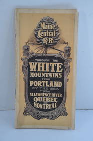
Maine Central RR Through the White Mtns-Portland to the St Lawrence River Book-1901JM Hobby Supply and Railroad Artifact Auctions4.4(127)See Sold PriceFeb 24, 2024
17TH C. WORLD MAP BY NICOLAES VISSCHER (NETHERLANDS, 1618-1709)Thomaston Place Auction Galleries4.4(393)See Sold PriceFeb 24, 2024
LATE 17TH C. FRENCH MAP OF THE NEW WORLD BY ALEXIS-HUBERT JAILLOT (1632-1712)Thomaston Place Auction Galleries4.4(393)See Sold PriceFeb 24, 2024
NICOLAES VISSCHER (NETHERLANDS, 1618-1709) MAP OF THE NEW WORLDThomaston Place Auction Galleries4.4(393)See Sold PriceFeb 24, 2024
Thomas Manley "Cincinnati" Dry Point EtchingPremier Auction Galleries4.4(331)See Sold PriceMar 09, 2024
3 Piece sterling silver picture frames, (1) Cartier frame, engraved Cartier label on top, measuresNeely Auction4.6(224)See Sold PriceFeb 25, 2024
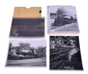
Seventy-Three Black and White Railroad Photographs and Film NegativesRail & Road Auctions4.6(165)See Sold PriceMar 07, 2024
Rand McNally Railroad Map Cabinet w/ 21 Railroad MapsRail & Road Auctions4.6(165)See Sold PriceMar 08, 2024
[WORLD WAR II – OKINAWA]. Okinawa Shima Western Beaches Top...Potter & Potter Auctions4.6(545)See Sold PriceMar 07, 2024
[CIGARETTE CARDS]. A Group of 22 “Ocean and River Steamers ...Potter & Potter Auctions4.6(545)See Sold PriceMar 07, 2024
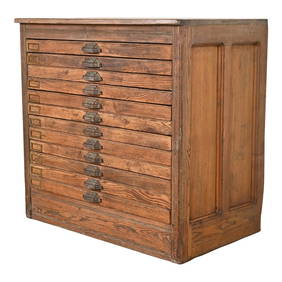
Antique Pine 12-Drawer Blueprint Flat File Cabinet by Hamilton, Circa 1900Liberty & 33rd Furniture Co.4.4(13)See Sold PriceFeb 27, 2024
![1858 Colton Map of Co-Tidal Lines [with] Ocean Currents and River Systems -- Map of the World First Image](https://p1.liveauctioneers.com/5584/289753/153469664_1_x.jpg?height=282&quality=95&version=1684878062&width=282)

![1858 Colton Map of Co-Tidal Lines [with] Ocean Currents and River Systems -- Map of the World First Image](https://p1.liveauctioneers.com/5584/289753/153469664_1_x.jpg?height=282&quality=1&version=1684878062&width=282)


![1858 Colton Map of Co-Tidal Lines [with] Ocean Currents and River Systems -- Map of the World (1 of 1)](https://p1.liveauctioneers.com/5584/289753/153469664_1_x.jpg?height=282&quality=70&version=1684878062)


![[WORLD WAR II – OKINAWA]. Okinawa Shima Western Beaches Top... (1 of 1)](https://p1.liveauctioneers.com/928/318880/171361141_1_x.jpg?height=282&quality=70&version=1707501302)
![[CIGARETTE CARDS]. A Group of 22 “Ocean and River Steamers ... (1 of 1)](https://p1.liveauctioneers.com/928/318880/171361499_1_x.jpg?height=282&quality=70&version=1707501302)