1952 MAY, J.F.K. HANDWRITTEN LETTER & ENVELOPEJohn McInnis Auctioneers,LLC4.6(502)See Sold PriceFeb 25, 2024
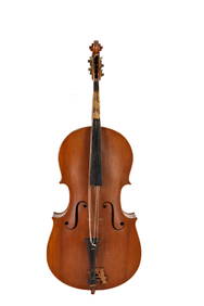
WARNER BECKMAN'S TIGER MAPLE CELLO / SEABROOK NHJohn McInnis Auctioneers,LLC4.6(502)See Sold PriceFeb 25, 2024
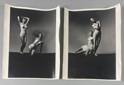
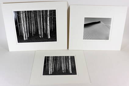
Victor Skrebneski Lingerie Fashion PhotographsEpic Auctions and Estate Sales4.6(204)See Sold PriceMar 02, 2024
[DOUGLASS, Frederick (1818-1895)]. ROBERTS, J.B., photographer. CDV of Frederick Douglass.Freeman's | Hindman4.4(1.6k)See Sold PriceFeb 27, 2024
1952 J.F.K. for SENATE TEAS & RECEPTION MATERIALJohn McInnis Auctioneers,LLC4.6(502)See Sold PriceFeb 25, 2024
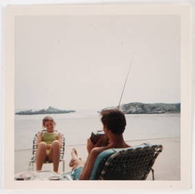
HUGH D. AUCHINCLOSS' 70th BIRTHDAY with FAMILYJohn McInnis Auctioneers,LLC4.6(502)See Sold PriceFeb 25, 2024
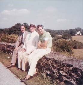
CAROLINE KENNEDY at BAILEYS BEACH, NEWPORT, RIJohn McInnis Auctioneers,LLC4.6(502)See Sold PriceFeb 25, 2024
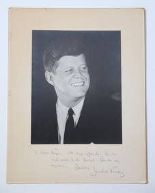
WILLIAM LINSMAN PHOTO SIGNED by JACKIE KENNEDYJohn McInnis Auctioneers,LLC4.6(502)See Sold PriceFeb 25, 2024
[BASEBALL]. Original Photographic Team Portrait of the Cuba...Potter & Potter Auctions4.6(539)See Sold PriceMar 07, 2024
Sold1855 Map North America by G. Virtue1855 map of North America by G. Virtue. Measures 13.375 in. x 9.875 in. G-VG/VG. Unframed, loose and not glued or mounted. If lot is absent of a condition report a condition report may be requested viSee Sold Price
SoldUS Map and Book Plate MapUS Map and Book Plate Map. A New Map of Part of the United States by John Cary; c. 1819; Some foxing and toning; 21" x 23". Small Book Plate Map of North America; London: published by G. Virtue; 13" xSee Sold Price
Map of North AmericaAntique map of North America showing the United States. Hand colored outlines. printed in London Published by G. Virtue 26 Ivy Ln. Shipping Domestic: Cost will vary depending upon location. InternatioSee Sold Price
Map of North AmericaAntique map of North America showing the United States. Hand colored outlines. printed in London Published by G. Virtue 26 Ivy Ln. Shipping Domestic: Cost will vary depending upon location. InternatioSee Sold Price
SoldUncommon map of the United States from 1855Heading: (North America) Author: Heck, G. Title: Vereinigte Staaten von Nordamerika Nebst Mexico Und Central Amerika Place Published: Leipzig Publisher:G. Heck Date Published: 1855 DescSee Sold Price
SoldA MAP "UNITED STATES NORTH AMERICA", G. H. SWANSTON,A MAP "UNITED STATES NORTH AMERICA", G. H. SWANSTON, 1849, Uncommon map with interesting western territories. Dakotah [sic] incorporates the territory between Minnesota and the Missouri River. The larSee Sold Price
Sold1855 Jonston Map of North America -- North AmericaTitle/Content of Map: 1855 Jonston Map of North America -- North America Cartographer: AK Johnston Year/Place: 1855, Edinburgh Size: 23.6 X 19.4 in. This is a very interesting double-page map of NorthSee Sold Price
SoldA MAP "UNITED STATES NORTH AMERICA," G. H. SWANSTON, 18A MAP "UNITED STATES NORTH AMERICA," G. H. SWANSTON, 1849, Uncommon map with interesting western territories. Dakotah [sic] incorporates the territory between Minnesota and the Missouri River. The larSee Sold Price
1855 Jonston Map of North America -- North AmericaTitle/Content of Map: 1855 Jonston Map of North America -- North America Cartographer: AK Johnston Year/Place: 1855, Edinburgh Size: 23.6 X 19.4 in. This is a very interesting double-page map of NorthSee Sold Price
Sold[Map] New Map North America 1855Jacob Monk ,Baltimore; North America and Territories, Canada,Central America and West Indies, 57 x 62 in. Large Roll down map.See Sold Price
Sold1855 Colton Map of North and Central America -- NorthTitle/Content of Map: 1855 Colton Map of North and Central America -- North America Date: 1855, New York Cartographer: J Colton Size: 14.8 X 12.5 in. This is an attractive map of North and Central AmeSee Sold Price
SoldColton: Map of North America, 1855Map: North America Cartographer: J.H. Colton Illustrator: J.H. Colton Publisher: J.H. Colton Co. Published: New York, 1855 Size: 12.75 x 15.75 inches Extremely nice example with very nice full hand-coSee Sold Price
Sold1855 Map of The East Coast Of North America 76x411855 Map of The East Coast Of North America 76x41See Sold Price
Climatological Map of North America, 1855Map: Climatological Map of North America Maker: J.H. Colton & Co., Joseph Hutchins Colton Date: 1855 Size: Quarto - 15.5 inches high x 13.3 inches wide Shows seasonal temperature limits and timber linSee Sold Price
Colton: Climatological Map of North America, 1855Map: Climatological Map of North America Publication Date: 1855 Authors: J.H. COLTON & CO., COLTON, JOSEPH HUTCHINS Publisher: J.H. COLTON & CO. Size: Quarto – 15.50 H x 13.30 W Inches Shows seasonaSee Sold Price
SoldMap of North America...Title: Map of North America... Publication Date: c1856 Cartographer: BOYNTON, G. W. Dimensions: 12Height - 9.1Width Publisher: HICKLING, SWAN & BROWN "... designed to illustrate Cartee's Physical & PoSee Sold Price
Sold1748 Robert de Vaugondy Map of North America --Title/Content of Map: 1748 Robert de Vaugondy Map of North America -- Amerique Septentrionale Date: 1748, Paris Cartographer: G Robert de Vaugondy Size: 6.3 X 7.8 in. Thisa is a rather nice map of theSee Sold Price
North America.Title/Content of Map: North America. Date Printed: 1855 ca. Cartographer: COLTON, J. H. & CO. Size: 14X12 British Columbia then called "New Georgia". Kansas then spelled "Kanzas". Unusual depictions iSee Sold Price
Sold1852 Philip Map of North and South America -- AmericaTitle/Content of Map: 1852 Philip Map of North and South America -- America Date: 1852, Liverpool Cartographer: G Philip Size: 11.9 x 9. 1 in. This is a handsome map of the Americas, offering detailsSee Sold Price
De L'Isle/Ottens: Antique Map of North America, 1730Title/Content of Map: North America by De L'Isle/Ottens Date Printed: c1730 Cartographer: G. De L'Isle/Ottens Material/Medium: Paper Size: 21" x 25" Hand colored copperplate engraved influential and iSee Sold Price
Philip: Antique Map of North and South America, 1852Title/Content of Map: 1852 Philip Map of North and South America -- America Date Printed: 1852, Liverpool Cartographer: G Philip Size: 11.9 x 9. 1 in. This is a handsome map of the Americas, offeringSee Sold Price
Superb Large Geological Map of U.S. & Canada - 1855Johnston, Alexander K. (1804-1971), & Rogers, Henry. D. (1808-1866). Geological Map of the United States and British North America...Lithographed map. William Blackwood & Sons, 1855. 20" x 24 ¼" shSee Sold Price
Map of North America...Title/Content of Map: Map of North America... Date Printed: 1856 ca. Cartographer: BOYNTON, G. W. Size: 12X9.1 "... designed to illustrate Cartee's Physical & Political Geography." Details mountain raSee Sold Price
Philip: Antique Map of North and South America, 1852Title/Content of Map: 1852 Philip Map of North and South America -- America Date Printed: 1852, Liverpool Cartographer: G Philip Size: 11.9 x 9. 1 in. This is a handsome map of the Americas, offeringSee Sold Price
5 Dollars - Elizabeth II Map of North AmericaWeatherham Estate Treasures3.9(157)See Sold PriceMar 07, 2024
Arrowsmith & Lewis - Map of North AmericaTrillium Antique Prints & Rare Books4.5(30)See Sold PriceFeb 24, 2024
Map: An 18thC engraved and hand coloured map of North America and South America, titled DeClaydon Auctioneers Ltd4.3(125)See Sold PriceFeb 26, 2024
1855 NOTES ON CENTRAL AMERICA by E. G. Squier antique w/ MAPSJasper524.5(9.8k)See Sold PriceFeb 27, 2024
1822 MAP of NORTH & SOUTH AMERICA GEOGRAPHICAL STATISTICAL HISTORICAL antiqueJasper524.5(9.8k)See Sold PriceFeb 27, 2024
New and Correct Map of North America With the West India Islands,Jasper524.5(9.8k)See Sold PriceFeb 27, 2024
Italian edition of Sanson's map of North America, 1677PBA Galleries4.7(381)See Sold PriceMar 07, 2024
Blackie (Pub) 1882 Folio Map. West USA - Pacific StatesAlbion Auctions4.6(336)See Sold PriceMar 01, 2024
Blackie (Pub) 1882 Folio Map. United States of North AmericaAlbion Auctions4.6(336)See Sold PriceMar 01, 2024


![[DOUGLASS, Frederick (1818-1895)]. ROBERTS, J.B., photographer. CDV of Frederick Douglass. (1 of 2)](https://p1.liveauctioneers.com/197/319238/171467829_1_x.jpg?height=282&quality=70&version=1707520367)


![[BASEBALL]. Original Photographic Team Portrait of the Cuba... (1 of 2)](https://p1.liveauctioneers.com/928/318880/171361386_1_x.jpg?height=282&quality=70&version=1707501302)


![[Map] New Map North America 1855 (1 of 4)](https://p1.liveauctioneers.com/523/85328/43939935_1_x.jpg?height=282&quality=70&version=1455914464)


