ATLAS of ANTIENT GEOGRAPHY by SAMUEL BUTLER 1843John McInnis Auctioneers,LLC4.6(502)See Sold PriceFeb 24, 2024
18TH C. ANTIQUE MAP: FRENCH & INDIAN WAR, FRAMEDThomaston Place Auction Galleries4.4(386)See Sold PriceFeb 24, 2024
Rand McNally Railroad Map Cabinet w/ 21 Railroad MapsRail & Road Auctions4.6(165)See Sold PriceMar 08, 2024
Keith Haring - Ink on New York Map, Best Buddies, Inscribed, Signed, and DatedSapphire Auction Gallery4(67)See Sold PriceMar 02, 2024
LATE 17TH C. FRENCH MAP OF THE NEW WORLD BY ALEXIS-HUBERT JAILLOT (1632-1712)Thomaston Place Auction Galleries4.4(386)See Sold PriceFeb 24, 2024
Central Railroad of New Jersey Map of Sandy Hook Route-ca. 1903JM Hobby Supply and Railroad Artifact Auctions4.4(126)See Sold PriceFeb 24, 2024
Lot of Six Mixed Atlas Box Cars-HO Scale-New in BoxJM Hobby Supply and Railroad Artifact Auctions4.4(126)See Sold PriceFeb 25, 2024
Rand McNally/Santa Fe Railroad Map of Iowa-1912JM Hobby Supply and Railroad Artifact Auctions4.4(126)See Sold PriceFeb 24, 2024
NICOLAES VISSCHER (NETHERLANDS, 1618-1709) MAP OF THE NEW WORLDThomaston Place Auction Galleries4.4(386)See Sold PriceFeb 24, 2024
17TH C. WORLD MAP BY NICOLAES VISSCHER (NETHERLANDS, 1618-1709)Thomaston Place Auction Galleries4.4(386)See Sold PriceFeb 24, 2024
Lot of Six Mixed Atlas Cabooses-HO Scale-New in BoxJM Hobby Supply and Railroad Artifact Auctions4.4(126)See Sold PriceFeb 25, 2024
SoldRARE EARLY MAP OF NORTH AMERICA - Matthias Seutter,RARE EARLY MAP OF NORTH AMERICA - Matthias Seutter, copperplate engraving on laid paper, with later hand coloring, circa 1730; "Recens Edita Totius novi Belgii in America Septentrionali siti DelineatoSee Sold Price
SoldJan Jansson Hand Colored Old Map of North AmericaJan Jansson (Johannes Janssonius; Dutch, 1588-1664). Framed antique etching print of North America. Titled AMERICA SEPTENTRIONALIS. Hand colored. Unknown printing date in two sheets joined in the middSee Sold Price
SoldPalairet / Kitchin: Map of English/French North AmericaMap: Carte des Possessions Angloises & Francoises du Continent de l'Amerique Septentrionale Cartographer: J. Palairet / Kitchin Place & Date: London / 1756 Size: 22 3/4" x 17" Condition: beautifully cSee Sold Price
SoldJaillot: Antique Map of North America, 1696Map: 1696 Jaillot Map of North America (California as an Island) -- Amerique Septentrionale Divisee en ses Principales Parties Date Printed: 1696 Amsterdam Cartographer: H. Jaillot Size: 19.3 x 23 in.See Sold Price
SoldMap of The Indian Tribes of North AmericaAbout 1600 A.D. Along the Atlantic and about 1800 A.D. Westerly. Publ. by Amer. Antiq. Soc. From a drawing by honorable A. Gallatin and Pendleton's Lithography. 16 5/8" x 15 1/2"See Sold Price
SoldEdward Wells, map North AmericaEdward Wells, map North America, Edward Wells (British, 1667-1727), "A New Map of North America Shewing its Principal Divisions, Chief Cities, Townes... Dedicated to His Highness William Duke of GloucSee Sold Price
New Map of United States of North America, 1805Map: A New Map of Part of the United States of North America, exhibiting the Western Territory, Kentucky, Pennsylvania, Maryland, Virginia &c., also the lakes Superior, Michigan, Huron, Ontario & ErieSee Sold Price
SoldMap of North America by Tobias Conrad LotterG.F. Lotter sculps. Professionally framed and matted. Sight size 20" x 25". Overall size 28 1/2" x 33 1/2". Good condition, vertical crease / fold through center.See Sold Price
SoldMoll / Oldmixon: Antique Map of North America, 1721Map: Nieuwe Kaart van Noord Amerika Cartographer: H. Moll / Oldmixon Place & Date: Amsterdam / 1721 Size: 9 3/4" x 6 3/4" Condition: outline color; overall age toning and minor spotting In this DutchSee Sold Price
Sold(Maps and Charts, North America), Speed, John (155(Maps and Charts, North America), Speed, John (1552-1629), America, with those known Parts in that unknown Worlde both people and manner of buildings described and enlarged, London: Bassett and ChiswSee Sold Price
SoldSamuel G Drake THE BOOK OF THE INDIANS OF NORTH AMERICASamuel G Drake THE BOOK OF THE INDIANS OF NORTH AMERICA 1833 Leatherbound Antique Gilt Engraved Illustrated Plates Illustrations Native Americans Wars Culture Orators History Biography Northern New EnSee Sold Price
Sold"Quadrupeds of North America" by John J. Audubon &"Quadrupeds of North America" by John J. Audubon & Rev. John Bachman.NY, George Lockwood, 1849.See Sold Price
SoldNorth America Monk's Wall Map 1859Published by Jacob Monk in 1859 in Baltimore. It is in fair to good condition for age. From Col. Elisha Camp's Federal Home in Sackets Harbor, NY.See Sold Price
SoldHistory of the Indian Tribes of North America by ThomasHistory of the Indian Tribes of North America by Thomas L. McKenney and James Hall, Esq. In two volumes with slipcase. Voltair Limited, 1978. Numbered edition 724 of 5,000.See Sold Price
Sold3 Vol. Set The Indian Tribes of North America3 Vol. Set The Indian Tribes of North America, 1934, McKenney and Hall complete with colored plates, very difficult to find todaySee Sold Price
SoldZimmerman- Waterfowl of North AmericaZimmerman, William, ''Waterfowl of North American'', 1974, 93 pages with 42 plates. Publisher The Frame House Gallery, Louisville, KY. Autographed copy No. 740 of 1000, limited edition. Green leatherSee Sold Price
Sold1885 History of Blessed Virgin Mary in North America1885 History of Blessed Virgin Mary in North America Catholic Church Illustrated Xavier MacLeod’s ‘History of the Devotion to the Blessed Virgin Mary’ is a 19th-century account of the history ofSee Sold Price
SoldHalibut Hook from 1920's-1930's Made from a very light wood and from Northwest North America. 10Halibut Hook from 1920's-1930's Made from a very light wood and from Northwest North America. 10 1/2" Long.See Sold Price
SoldGuthrie, William 1812 Hand Col Map of North AmericaHand Coloured Copper Engraved Map Published 1812, London for "A New Geographical, Historical and Commercial Grammar..." by William Guthrie. The maps are by John Senex, Thomas Kitchin and others. PaperSee Sold Price
SoldGibson: British Governments in North America, 1763Map: The British Governments in North America Laid Down Agreeable to the Proclamation of Octr. 7, 1763 Cartographer: John Gibson Publisher: The Gentleman's Magazine Published: London, 1763 Size: 8 x 9See Sold Price
J. Tallis: North America, 1851Map: North America Cartographer: J. Tallis Publishing: London, 1851 Size: 14 x 9.5 inches This is a decorative and striking steel engraved map of North America, featuring Texas with an enlarged panhanSee Sold Price
SoldBook Birdstone of North AmericaBook Birdstone of North America #373 by Earl Townsend, original copySee Sold Price
Hondius / Janssonius: Antique Map of North America 1647Title: America Septentrionalis. Seminal 1647 map of North America with California as an island Map maker: Henricus Hondius & Jan Janssonius Place and Year: Amsterdam, 1647 Dimensions: 46.8 x 55.5 cm (See Sold Price
De L'Isle/Ottens: Antique Map of North America, 1730Title/Content of Map: North America by De L'Isle/Ottens Date Printed: c1730 Cartographer: G. De L'Isle/Ottens Material/Medium: Paper Size: 21" x 25" Hand colored copperplate engraved influential and iSee Sold Price
LARGE EARLY 18TH C. DUTCH CHART OF UPPER NORTH AMERICA, PIERRE MORTIER (1661-1711), FRAMEDThomaston Place Auction Galleries4.4(386)See Sold PriceFeb 24, 2024
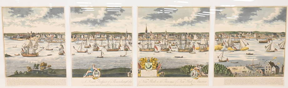
A South Prospect of Ye Flourishing City of New York in the Province of New York, North AmericaNadeau's Auction Gallery4.7(401)See Sold PriceFeb 24, 2024
The Art of Hunting Big Game in North America 1967North American Artifact Auctions4.6(182)See Sold PriceApr 20, 2024
Audubon's Animals - The Quadrupeds of North America 1954 Folio Size BookNorth American Artifact Auctions4.6(182)See Sold PriceApr 20, 2024
Audubon's Quadrupeds of North America 1989 NEW or FINE Condition Folio SizeNorth American Artifact Auctions4.6(182)See Sold PriceApr 20, 2024
Arrowsmith & Lewis - Map of North AmericaTrillium Antique Prints & Rare Books4.5(30)See Sold PriceFeb 24, 2024
Map: An 18thC engraved and hand coloured map of North America and South America, titled DeClaydon Auctioneers Ltd4.3(125)See Sold PriceFeb 26, 2024
1862 North America Anthony Trollope West Indies AND Spanish Main CANADA NIAGARAJasper524.5(9.8k)See Sold PriceFeb 27, 2024
New and Correct Map of North America With the West India Islands,Jasper524.5(9.8k)See Sold PriceFeb 27, 2024
Blackie (Pub) 1882 Folio Map. United States of North AmericaAlbion Auctions4.6(336)See Sold PriceMar 01, 2024
Map of United States of North America, 1785Antiques Online Auctions4.6(407)See Sold PriceMar 14, 2024