ATLAS of ANTIENT GEOGRAPHY by SAMUEL BUTLER 1843John McInnis Auctioneers,LLC4.6(504)See Sold PriceFeb 24, 2024
18TH C. ANTIQUE MAP: FRENCH & INDIAN WAR, FRAMEDThomaston Place Auction Galleries4.4(389)See Sold PriceFeb 24, 2024
Rand McNally Railroad Map Cabinet w/ 21 Railroad MapsRail & Road Auctions4.6(165)See Sold PriceMar 08, 2024
Keith Haring - Ink on New York Map, Best Buddies, Inscribed, Signed, and DatedSapphire Auction Gallery4.1(67)See Sold PriceMar 02, 2024
LATE 17TH C. FRENCH MAP OF THE NEW WORLD BY ALEXIS-HUBERT JAILLOT (1632-1712)Thomaston Place Auction Galleries4.4(389)See Sold PriceFeb 24, 2024
Central Railroad of New Jersey Map of Sandy Hook Route-ca. 1903JM Hobby Supply and Railroad Artifact Auctions4.4(126)See Sold PriceFeb 24, 2024
Lot of Six Mixed Atlas Box Cars-HO Scale-New in BoxJM Hobby Supply and Railroad Artifact Auctions4.4(126)See Sold PriceFeb 25, 2024
Rand McNally/Santa Fe Railroad Map of Iowa-1912JM Hobby Supply and Railroad Artifact Auctions4.4(126)See Sold PriceFeb 24, 2024
NICOLAES VISSCHER (NETHERLANDS, 1618-1709) MAP OF THE NEW WORLDThomaston Place Auction Galleries4.4(389)See Sold PriceFeb 24, 2024
17TH C. WORLD MAP BY NICOLAES VISSCHER (NETHERLANDS, 1618-1709)Thomaston Place Auction Galleries4.4(389)See Sold PriceFeb 24, 2024
Lot of Six Mixed Atlas Cabooses-HO Scale-New in BoxJM Hobby Supply and Railroad Artifact Auctions4.4(126)See Sold PriceFeb 25, 2024
1850 Tallis Map of Syria / Israel -- Syria1850 Tallis Map of Syria / Israel -- Syria 1851 London J. Tallis 13 x 10 in. This is an ornate and highly decorative map of Syria, filled with detail. There is also good detail on present day Lebanon,See Sold Price
Sold1850 Tallis Map of Syria / Israel -- SyriaTitle/Content of Map: 1850 Tallis Map of Syria / Israel -- Syria Date: 1851 London Cartographer: J. Tallis Size: 13 x 10 in. This is an ornate and highly decorative map of Syria, filled with detail. TSee Sold Price
1850 Tallis Map of Syria / Israel -- SyriaTitle/Content of Map: 1850 Tallis Map of Syria / Israel -- Syria Date: 1851 London Cartographer: J. Tallis Size: 13 x 10 in. This is an ornate and highly decorative map of Syria, filled with detail. TSee Sold Price
1850 Tallis Map of Syria / Israel -- SyriaTitle/Content of Map: 1850 Tallis Map of Syria / Israel -- Syria Date: 1851 London Cartographer: J. Tallis Size: 13 x 10 in. This is an ornate and highly decorative map of Syria, filled with detail. TSee Sold Price
1850 Tallis Map of Syria / Israel -- SyriaTitle/Content of Map: 1850 Tallis Map of Syria / Israel -- Syria Date Printed: 1851 London Cartographer: J. Tallis Size: 13 x 10 in. This is an ornate and highly decorative map of Syria, filled with dSee Sold Price
1850 Tallis Map of Syria / Israel1850 Tallis Map of Syria / Israel J. Tallis 1851 London 13 x 10 in. This is an ornate and highly decorative map of Syria, filled with detail. There is also good detail on present day Lebanon, and IsraSee Sold Price
1850 Tallis Antique Map of Syria / IsraelTitle/Content of Map: 1850 Tallis Map of Syria / Israel -- Syria Date Printed: 1851 London Cartographer: J. Tallis Size: 13 x 10 in. This is an ornate and highly decorative map of Syria, filled with dSee Sold Price
Tallis: Map of Syria / Israel, 1850Map: 1850 Tallis Map of Syria / Israel -- Syria Cartographer: J. Tallis Year / Place: 1851 London Map Dimensions: 13 x 10 in. Condition: Very Good. Slight age toning on edges, and the center fold, asSee Sold Price
Tallis: Antique Map of Syria / Israel, 1850Map: 1850 Tallis Map of Syria / Israel -- Syria Cartographer: J. Tallis Year / Place: 1851 London Dimensions: 13 x 10 in. Condition: Very Good. Slight age toning on edges, and the center fold, as issuSee Sold Price
Tallis: Antique Map of Syria / Israel, 1850Title/Content of Map: 1850 Tallis Map of Syria / Israel -- Syria Date Printed: 1851 London Cartographer: J. Tallis Size: 13 x 10 in. This is an ornate and highly decorative map of Syria, filled with dSee Sold Price
SoldDetailed Map of Eretz Israel, Syria and Egypt -Regni Davidici et salomonaei descriptio geographica cum vicinis regionibus Syriae et Aegypti / Schema II [geographic description of David and Solomon Kingdoms and the regions of Syria and Egypt/map noSee Sold Price
Map of Northern Israel and Syria from 'Cosmography' bymap of the north of Israel and Syria hand-painted, a woodcut from Sebastian Munster's book "Cosmography". Published by Heinrich Petri, Basel, 1550. 33X21 cm. Good - very good condition.See Sold Price
SoldSYRIA. Levant Palestine Jordan Lebanon Israel Cyprus.TITLE/CONTENT OF MAP: 'Syria' Vignettes: Arabs; Jerusalem DATE PRINTED: 1851 IMAGE SIZE: Approx 36.5 x 26.5cm, 14.5 x 10.25 inches (Large) TYPE: Antique engraved map by J Rapkin, published by John TalSee Sold Price
SoldCollection of [5] Maps of the Middle East and Environs* Nuova Carta di Irak Arabi, Kurdistan Diarbek Turcomannia Siria, e Palestina, map of Iraq, Arabia, Diarbek, Turkmenistan, Syria and the Land of Israel. 1740, 30x35 cm. * Syria, Cyprus, Palestina, MesSee Sold Price
A C19th engraved map of Syria by J. Rapkin, publishedA C19th engraved map of Syria by J. Rapkin, published by J & F Tallis, 10'' x 13½''See Sold Price
SoldOttoman Empire in Asia. Turkey, Iraq, Jordan, Syria,Title: Ottoman Empire in Asia. Turkey, Iraq, Jordan, Syria, Lebanon and Palestine. 1850 by Thomas. Date/Period: c1850. Materials: Hand colored steel engraved Size: 16 1/2 x 13 1/2 inches. c1850 by ThoSee Sold Price
MIDDLE EAST. Turkey Transjordan Palestine Israel Syria Levant States 1938 mapTITLE/CONTENT OF MAP: 'Western Asia; Palestine' DATE PRINTED: 1938 IMAGE SIZE: Approx 26.5 x 35.5cm, 10.25 x 14 inches (Large) TYPE: Vintage colour map: Scale 1:10,000,000; 1:1,400,000 CONDITION: GoodSee Sold Price
Sold1850 Tallis Map of Australia -- AustraliaTitle/Content of Map: 1850 Tallis Map of Australia -- Australia Date Printed: 1850 London Cartographer: J. Tallis Size: 10 x 13 in. This highly attractive steel engraved map of Australia is with largeSee Sold Price
1850 Tallis Map of Southern Italy1850 Tallis Map of Southern Italy J Tallis 1850 London 10 x 13 in. This ornate and highly decorative map of Southern Italy. It illustrates regions largely south of the Papal States, including Sicily,See Sold Price
1850 Tallis map of Ontario, Canada -- West CanadaTitle/Content of Map: 1850 Tallis map of Ontario, Canada -- West Canada Date: 1850, London Cartographer: J Tallis Size: 10 X 13 in. A very nice map of today's Ontario surrounded in a decorative borderSee Sold Price
Sold1850 Tallis Map of North America -- North AmericaTitle/Content of Map: 1850 Tallis Map of North America -- North America Cartographer: J Tallis Year/Place: 1850, London Size: 14 x 9.5 in. This is a highly decorative and striking steel engraved map oSee Sold Price
Sold1850 Tallis Map of North America -- North AmericaReserve Reduced! Title/Content of Map: 1850 Tallis Map of North America -- North America Date: 1850, London Cartographer: J Tallis Size: 14 x 9.5 in. This is a decorative and striking steel engraved mSee Sold Price
Sold1850 Tallis Map of the Black Sea Region -- Black SeaTitle/Content of Map: 1850 Tallis Map of the Black Sea Region -- Black Sea Cartographer: J Tallis Year/Place: 1850, London Size: 9.8 X 12.3 in. This is an excellent map of the Balck Sea area, technicaSee Sold Price
Sold1850 Tallis Map of Quebec and New Brunswick -- EastTitle/Content of Map: 1850 Tallis Map of Quebec and New Brunswick -- East Canada and New Brunswick Date: 1850, London Cartographer: J Tallis Size: 10.5 X 13.5 in. This is quite attractive map of the SSee Sold Price
Ohio and Pennsylvania RR 2nd Annual Report-March 4, 1850JM Hobby Supply and Railroad Artifact Auctions4.4(126)See Sold PriceFeb 24, 2024
DAVID ROBERTS - Holy Land / Syria / Egypt etc. 3 x Folio Volumes 1849 Very RareLuis Porretta Fine Arts4.3(10)See Sold PriceMar 02, 2024
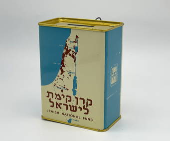
Jewish National Fund Collection Box - Great BritainLevy Auction House4.3(11)See Sold PriceFeb 27, 2024
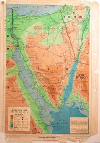
Eretz Israel Map Postcard - World Zionist OrganizationLevy Auction House4.3(11)See Sold PriceFeb 27, 2024
Collection of 10 Maps of Cities in Israel for TouristsLevy Auction House4.3(11)See Sold PriceFeb 27, 2024
Illustrated Sabbath Cloth - Holy Sites of Eretz IsraelLevy Auction House4.3(11)See Sold PriceFeb 27, 2024
1886 Cities of BASHAN Holy Land SYRIA Palestine Israel Jerusalem History BibleSchilb Antiquarian Rare Books4.8(422)See Sold PriceMar 31, 2024
[MAPS]. DUFOUR, Auguste-Henri (1795-1865). Bound Volume of ...Potter & Potter Auctions4.6(544)See Sold PriceMar 07, 2024
Nottingham.- Ordnance Survey Office (publisher) Collection 8 geological maps on the environs ofForum Auctions4.3(53)See Sold PriceFeb 29, 2024
NORTHERN AFRICA. Morocco Tunisia Algeria. Caravan routes. RAPKIN/TALLIS 1851 mapJasper524.5(9.8k)See Sold PriceFeb 28, 2024
Carte de L'Algérie et de la Régence de Tunis' ANDRIVEAU-GOUJON Algeria 1850 mapJasper524.5(9.8k)See Sold PriceFeb 28, 2024
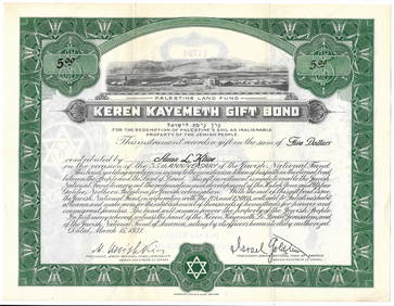
Alfred Salzman, Etc. JNF Tin Tzedakah Boxes, 3Auctions at Showplace4.6(731)See Sold PriceApr 07, 2024
Fifteen American Fiddleback Coin Silver Spoons by Various MakersGray's Auctioneers4.5(187)See Sold PriceMar 06, 2024
ANTIQUE 1686 OPERA OMNIA BY JOHN LIGHTFOOT TELLIMA BOUND FOLIO WITH ISRAEL MAPNY Elizabeth 4.3(85)See Sold PriceMar 03, 2024


![Collection of [5] Maps of the Middle East and Environs (1 of 5)](https://p1.liveauctioneers.com/2398/129929/66072853_1_x.jpg?height=282&quality=70&version=1540446977)


![[MAPS]. DUFOUR, Auguste-Henri (1795-1865). Bound Volume of ... (1 of 2)](https://p1.liveauctioneers.com/928/318880/171361279_1_x.jpg?height=282&quality=70&version=1707501302)