ATLAS of ANTIENT GEOGRAPHY by SAMUEL BUTLER 1843John McInnis Auctioneers,LLC4.5(505)See Sold PriceFeb 24, 2024
18TH C. ANTIQUE MAP: FRENCH & INDIAN WAR, FRAMEDThomaston Place Auction Galleries4.4(394)See Sold PriceFeb 24, 2024
Rand McNally Railroad Map Cabinet w/ 21 Railroad MapsRail & Road Auctions4.6(165)See Sold PriceMar 08, 2024
Keith Haring - Ink on New York Map, Best Buddies, Inscribed, Signed, and DatedSapphire Auction Gallery4.1(67)See Sold PriceMar 02, 2024
LATE 17TH C. FRENCH MAP OF THE NEW WORLD BY ALEXIS-HUBERT JAILLOT (1632-1712)Thomaston Place Auction Galleries4.4(394)See Sold PriceFeb 24, 2024
Central Railroad of New Jersey Map of Sandy Hook Route-ca. 1903JM Hobby Supply and Railroad Artifact Auctions4.4(127)See Sold PriceFeb 24, 2024
Lot of Six Mixed Atlas Box Cars-HO Scale-New in BoxJM Hobby Supply and Railroad Artifact Auctions4.4(127)See Sold PriceFeb 25, 2024
Rand McNally/Santa Fe Railroad Map of Iowa-1912JM Hobby Supply and Railroad Artifact Auctions4.4(127)See Sold PriceFeb 24, 2024
NICOLAES VISSCHER (NETHERLANDS, 1618-1709) MAP OF THE NEW WORLDThomaston Place Auction Galleries4.4(394)See Sold PriceFeb 24, 2024
17TH C. WORLD MAP BY NICOLAES VISSCHER (NETHERLANDS, 1618-1709)Thomaston Place Auction Galleries4.4(394)See Sold PriceFeb 24, 2024
Lot of Six Mixed Atlas Cabooses-HO Scale-New in BoxJM Hobby Supply and Railroad Artifact Auctions4.4(127)See Sold PriceFeb 25, 2024
Sold1849 Cushing & Walling City of Providence MapUnited states,1849Rare folding map of Providence, Rhode Island by Samuel B Cushing & Walling, published by Gladding & Proud, Providence. Map of Providence, extending also to Cranston, Johnston, NorthSee Sold Price
SoldMitchell: Map of City of New York, 1849An original steel engraved map of New York City published by Augustus Mitchell in 1849, with original hand coloring. Manhattan from about 37th St with Brooklyn and Williamsburg. Key to public buildingSee Sold Price
SoldMap of New York City region 1849Heading: (New York City) Author: Sidney, James C. Title: Sidney's map of Twelve Miles Around New-York With the Names of Property Holders, &c. from entirely new & original Surveys... Place Published: NSee Sold Price
SoldWall map of Providence Co. Rhode Island 1851Heading: (Rhode Island) Author: Walling, Henry Francis Title: Map of Providence County, Rhode Island, with some of the adjacent towns Place Published: Providence, RI Publisher:O.C. Brown, PublisherSee Sold Price
Sold(3) OLD NEW YORK CITY MAPS, VALENTINE'S MANUALIncluding "Plan of the City of New York (1755)" 1849. Dimensions: (Largest) H 18" x W 10.75" Condition: Removed from book, folds, edge losses, toningSee Sold Price
SoldDetailed Map of TransylvaniaSteel engraved colored map of Transylvania from "Meyer s Handatlas" published by Hauptmann Radefeld in 1849. The map shows many cities, villages with political regions handcolored in outline. Dimm_:40See Sold Price
Warren: Antique View of Providence 1870Map: Beautiful animated view of the city of Providence from Prospect Hill Park of 1870 circa. Author: R. Hinshelwood on drawing by Warren Date: 1870 circa Technique: Steel etching Leaf Dimension: 21x2See Sold Price
View of Providence 1870 circa Steel etching HinshelwoodBeautiful animated view of the city of Providence from Prospect Hill Park of 1870 circa. Author: R. Hinshelwood on drawing by Warren Date: 1870 circa Technique: Steel etching Leaf Dimension: 21x29,5 cSee Sold Price
View of Providence 1870 circa Steel etching HinshelwoodBeautiful animated view of the city of Providence from Prospect Hill Park of 1870 circa. Author: R. Hinshelwood on drawing by Warren Date: 1870 circa Technique: Steel etching Leaf Dimension: 21x29,5 cSee Sold Price
SoldVERY RARE WALL MAP OF THE CITY OF BANGOR,PENOBSCOT COUNTY, MAINE. 1853, Bangor, Maine. "Published Under the Patronage of the City Government Henry F. Walling, Civil Engineer, 81 Washington St. Boston 1853". "S.S. Smith, Publisher 17 West MarSee Sold Price
SoldLarge folding map of Phliadelphia 1849Title: Map of the City of Philadelphia together with All the surrounding Districts, including Camden, N.J. From Official Records, plans of the district surveyors & Original Surveys by J. C. Sidney CivSee Sold Price
Sold1849 NEW ORLEANS FLOODFirst Reports with Large Map of the City Inundated. New York Daily Tribune: June 14, 1849. 4 pp complete newspaper with large block map above the front fold of the flooding by the Mississippi in New OSee Sold Price
SoldRare folding map of Albany, NY, 1890Title: City of Albany, New York. From official records furnished by Reuben H. Bingham, City Surveyor Author: Walling, H. F. Description: Folding lithographed map, hand-colored. 53x59 cm. (20¾x23¾"),See Sold Price
SoldBrooklyn, New York 1849 Surveyors MapBrooklyn May 1849; Surveyed by Willard Day, City Surveyor. Measures 27 in. x 12.75. Paper mounted on cloth. Featured are Franklin Avenue, Kent Avenue, Graham Street and more. Owner names on plats. ProSee Sold Price
SoldSCHOOLROOM MAP1862 Map of the State of Maine by HF Walling, published by J. Chace Jr., Portland, Maine, with inset maps of the United States & the World, detail maps of the major cities and towns, view of mountainsSee Sold Price
SoldBradford: Antique Map of Early American Cities, 1835Title/Content of Map: Early American Cities: New York, Portland (MI), Boston, Providence, Baltimore, Albany, Philadelphia, Charleston, Savanna, New Orleans, St. Louis, Louisville, Nashville, CincinnatSee Sold Price
Sold1871 Topographical Atlas of Massachusetts, Walling1871 Atlas of Massachusetts complete with twenty-six hand colored printed maps of individual counties and cities with New England and U.S. Map included. Atlas titled, "OFFICIAL TOPOGRAPHICAL ATLAS OFSee Sold Price
31 Engravings- Cities of the world - Year 1849Lot composed of 15 sheets with 30 engravings and a map with the eastern hemisphere. Year: 1849 Sheet size: 25 cm x 16,5 cm each Venice, Jerusalem, Mexico, California, Madrid, Toledo, Italy, Tenerife,See Sold Price
31 Engravings- Cities of the world - Year 1849Lot composed of 15 sheets with 30 engravings and a map with the eastern hemisphere. Year: 1849 Sheet size: 25 cm x 16,5 cm each Venice, Jerusalem, Mexico, California, Madrid, Toledo, Italy, Tenerife,See Sold Price
Sold1856 CITY OF NEWPORT, RI TAX BOOK & 1885 MAP OF RITax book includes record of John Auchincloss of NY. soft cover bound. Providence, RI H.H., Brown printer. 36pp. Road Map of the Island of Rhode Island surveyed by Wm. Lawton C.E. Hammett publisher 36See Sold Price
SoldMeyer: Antique Map of Philadelphia, 1849Philadelphia A superb street plan of Philadelphia from Meyer's Auswanderungs-Atlas (Emigrant's Atlas) of North America, with a letter key to the city's wards and numbered keys to its major buildings aSee Sold Price
SoldUnknown, "Map of Upper California by the U.S. EX., EX."Unknown, "Map of Upper California by the U.S. EX., EX." 1849, H. -10 1/2 in., W. - 13 5/8 in.See Sold Price
SoldRare medical map of Cholera outbreak in Boston 1849Heading: (Boston) Author: Title: Report of the Committee of Internal Health on the Asiatic Cholera, Together with a Report of the City Physician on the Cholera Hospital Place Published: Boston PublisSee Sold Price
SoldThe 1849 Baltimore Cholera Epidemic with MapHeading: Author: Buckler, Th. H. Title: A History of Epidemic Cholera, as it appeared at the Baltimore City and County Alms-House, in the Summer of 1849, with some Remarks on the Medical Topography aSee Sold Price
Kenyons Pocket Map and Shippers Guide of Wisconsin-1914JM Hobby Supply and Railroad Artifact Auctions4.4(127)See Sold PriceFeb 24, 2024
Chicago Milwaukee and St Paul RY Panama Pacific Exposition Brochure-1915JM Hobby Supply and Railroad Artifact Auctions4.4(127)See Sold PriceFeb 24, 2024
Erie Railway Tourist Book/Magazine-1874JM Hobby Supply and Railroad Artifact Auctions4.4(127)See Sold PriceFeb 24, 2024
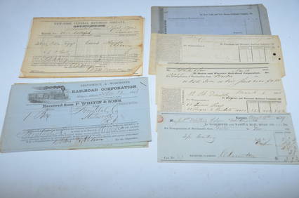
Bills of Lading, Checks, other Paper from 1840s-1860s-Eastern USA RailroadsJM Hobby Supply and Railroad Artifact Auctions4.4(127)See Sold PriceFeb 24, 2024
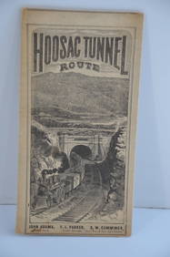
Fitchburg Railroad 1880 Hoosac Tunnel Route Public TimetableJM Hobby Supply and Railroad Artifact Auctions4.4(127)See Sold PriceFeb 24, 2024
Map UNITED COUNTIES LEEDS & GRENVILLE by Walling 1861 Rare Canada Map 5ft x 5ftLuis Porretta Fine Arts4.3(10)See Sold PriceMar 02, 2024
1849 Mitchell School ATLAS 24 MAPS America Holy Land France Africa Egypt AsiaSchilb Antiquarian Rare Books4.8(431)See Sold PriceMar 31, 2024
1888 Hand Book of the Pennsylvania Lines Containing Maps of Principal Cities - First EditionRail & Road Auctions4.6(165)See Sold PriceMar 07, 2024
Hand Colored Map of the city of Amsterdam 1720Global Auctions Company4.3(36)See Sold PriceMar 03, 2024
1849 THE NEW-ENGLAND MERCANTILE UNIONNorth American Artifact Auctions4.7(201)See Sold PriceApr 20, 2024
Julien Dillens (Belgian, 1849-1904), Patinated Bronze Relief Plaque, H.- 2 3/4 in., W.- 2 in., D.-Crescent City Auction Gallery4.3(233)See Sold PriceMar 01, 2024
Two Hand-Colored 19th Century Maps of New Orleans and Louisiana, Larger- H.- 12 1/2 in., W.- 15 1/2Crescent City Auction Gallery4.3(233)See Sold PriceMar 08, 2024
"Map of the Parishes of Iberville Most of West Baton Rouge and Including Parts of the Parishes ofCrescent City Auction Gallery4.3(233)See Sold PriceMar 09, 2024
1849 Orr & Co. Hand Colored Southern Germany MapMatthew Bullock Auctioneers4.7(1.9k)See Sold PriceMar 02, 2024
SCIENCE, MEMORY, NATURE. 12 BOOKS SOLD TOGETHERToronto Book Auctions4.3(13)See Sold PriceMar 07, 2024
Vintage Street Map of Pittsburgh, Pennsylvania - Rand McNallyProverde Auctions4.3(3)See Sold PriceFeb 28, 2024
Vintage Map of Roman Forum - Vatican City - Versailles parkProverde Auctions4.3(3)See Sold PriceFeb 28, 2024
Vintage Australia Airplane Ashtray [Kangaroo]Grant Zahajko Auctions, LLC4.8(1k)See Sold PriceMar 06, 2024
8PC United States Police Department Guide BooksBruneau & Co. Auctioneers4.5(491)See Sold PriceMar 18, 2024


![Vintage Australia Airplane Ashtray [Kangaroo] (1 of 7)](https://p1.liveauctioneers.com/5755/320282/172113950_1_x.jpg?height=282&quality=70&version=1708463029)
