Sold1836-38. A General Map of Ireland - RailwaysA General Map of Ireland to Accompany the Report of The Railway Commissioners Showing the Principal Physical Features and Geological Structure of the Country. coloured engraving, canvas backed 183 bySee Sold Price
SoldA General Map of Ireland to Accompany the Report ...A General Map of Ireland to Accompany the Report of the Railway Commissioners. Richard Griffith. engraved map with original hand-color in full (6 sheets laid down on cartographic linen, each in 12 segSee Sold Price
Griffith (Richard) A General Map of IrelandGriffith (Richard) A General Map of Ireland,to accompany the report of the Railway Commissioners, 6 seperate hand-coloured lithograph sheets, dissected and backed on linen, 780mm x 635mm, verySee Sold Price
SoldBartholomew, John 1904 Lot of 4 Railway Maps UK IrelandRailways of Scotland, Ireland, England & Wales, and General Map of the British Isles with Railway & Steamship Routes. Lithograph Map Published 1904, London for "The Survey Gazetteer of the British IslSee Sold Price
SoldWILLIAM FADEN (BRITISH, 1749-1836) MAP OF IRELANDWILLIAM FADEN (BRITISH, 1749-1836) MAP OF IRELAND, engraving on paper laid on linen, titled "Ireland Civil and Ecclesiastical" and dedicated to "His Majesty King George the Third", with early hand-colSee Sold Price
Bernard ScaleBernard Scale,General Map of Ireland,Published: Robert Sayer and John BennettFeb 1776,(missing front cover)See Sold Price
SoldIreland.- Moll (Herman) A Set of Twenty New and CorrectIreland.- Moll (Herman) A Set of Twenty New and Correct Maps of Ireland, first edition, printed title-page, folding engraved general map of Ireland, 17 engraved county/province maps and engraved ListSee Sold Price
Sold1836 Map of Dublin, IrelandDESCRIPTION: Drawn by W. B. Clarke, engraved by E. Turrell, and published by Baldwin & Cradock. Conservation framed. MEASUREMENTS: Map 11" high x 15" wide; overall with frame 20-1/2" high x 23-1/2" wiSee Sold Price
Sold1836 Map of Durham Railway IllustratedA English county map of Durham circa 1860 with illustrations in the corners. Also marking railway stations. By tHomas Moule. Fine, light loss t lower left corner. Fine. Measures 10.5 x 8.5". Reserve:See Sold Price
Hall: Antique Map of Ireland, 1856TITLE/CONTENT OF MAP: 'Ireland' showing counties & railways DATE PRINTED: 1856 IMAGE SIZE: Approx 54.0 x 41.5cm, 21.25 x 16.25 inches (Large); Please note that this is a folding map. TYPE: Antique atlSee Sold Price
SoldFaden A MAP OF IRELAND 1798 Engraved Period HandDetails: FADEN, William (1750-1836). A Map of Ireland divided into Provinces and Counties, shewing [sic.] the Great and Cross Roads with the Distances of the principal Towns from Dublin. London: PublSee Sold Price
SoldENGLAND & WALES NORTH. Railways companies canals coachTITLE/CONTENT OF MAP: 'General Railway map-Northern Section; Inset map of Manchester' This map is folding hence the centrefold line may show on the image below DATE PRINTED: 1903 IMAGE SIZE: Approx 44See Sold Price
SoldSidney Hall: Antique Map of Ireland, 1856Title/Content of Map: Ireland showing counties & railways Date Printed: 1856 Image Size: Approx 54.0 x 41.5cm, 21.25 x 16.25 inches (Large); Please note that this is a folding map. Type: Antique atlasSee Sold Price
Large map of U.S. Railroads 1918Title: General Railway Map Engraved Expressly for the Official Guide of the Railways and Steam Navigation Lines of the United States... Author: ** Description: Engraved map, outline color, sectioned &See Sold Price
Arkansas & Memphis Railway Bridge & Terminal CompanyTITLE/CONTENT OF MAP: 'A. & M.R.B.& T. Co Memphis, Tenn. General map [Arkansas & Memphis Railway Bridge & Terminal Co.]' DATE: The publication date is unknown but is assumed to be close to the date ofSee Sold Price
SoldSCOTLAND general map showing castles & kirks. Railways.TITLE/CONTENT OF MAP: 'SCOTLAND' The map shows some early railways The top image on the right hand side shows the entire map. To view a close up of the map showing the level of printed detail, pleaseSee Sold Price
1962 British Railways "Northern Ireland" map poste1962 British Railways "Northern Ireland" map poster Possibly by Daphne Padden. LM28462. The Baynard Press102 by 64cm., 40 by 25in.See Sold Price
Speed (John) - England, Wales, Scotland and Ireland,engraved pictorial title and 62 engraved maps including one folding (lacking folding general map 'England, Scotland and Ireland'), folding map with two small closed tears along folds, map 43 with smalSee Sold Price
SoldTanner: Map of Ireland, 1836Map: Map of Ireland Cartographer: Henry S. Tanner Date: 1836 Origin: Philadelphia Size: 11.8 x 9.4 inches A very attractive Tanner map of Ireland, hand colored by county and showing details for towns,See Sold Price
Southern Railways General system map, reproduced bySouthern Railways General system map, reproduced by courtesy of British Railway Board, 55cm x 25cmSee Sold Price
SoldWall hanging railway map of Ireland, dated 1912,Wall hanging railway map of Ireland, dated 1912, together with a publication ' The Railway Age ' 1981See Sold Price
SoldTravel Poster Ireland Illustrated Pictorial Map British Railways BurleyOriginal vintage travel poster featuring a Map of Ireland produced by British Railways in co-operation with Bord Failte Eireann, the map shows places of note and interest, held with a frame depictingSee Sold Price
SoldLewis's Atlas comprising the Counties of Ireland and aLewis's Atlas comprising the Counties of Ireland and a General Map of the Kingdom, 1837, and Lewis's Topographical Dictionary of Ireland, 2 vols (bindings poor) (3) See illustrationSee Sold Price
Homann (Heirs of) Great Britain and IrelandHomann (Heirs of) A General Map of Great Britain and Ireland,with Part of Holland, Flanders, France &c. Agreeable to modern History, decorative Latin title cartouche upper left, English in uppSee Sold Price
Crams Colored Railway Map and Shippers Guide of South Dakota 1908-1909JM Hobby Supply and Railroad Artifact Auctions4.4(126)See Sold PriceFeb 24, 2024
New York Central and Hudson River RR ca 1880s Public TimetableJM Hobby Supply and Railroad Artifact Auctions4.4(126)See Sold PriceFeb 24, 2024
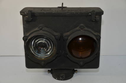
General Railway Signal Company Two Sided Double Head SignalJM Hobby Supply and Railroad Artifact Auctions4.4(126)See Sold PriceFeb 24, 2024
Portfolio of 15 County Maps by Robert Morden (English 1650-1703)Nadeau's Auction Gallery4.7(405)See Sold PriceFeb 24, 2024
Pair of Early Railroad Maps - 1874 Delaware, Lackawanna & Western and 1876 Pennsylvania RailroadRail & Road Auctions4.6(165)See Sold PriceMar 07, 2024
Pair of Early Railroad Maps - 1862 Pittsburgh, Ft. Wayne & Chicago Railway and 1873 PennsylvaniaRail & Road Auctions4.6(165)See Sold PriceMar 07, 2024
Group of Ten Railroad Photographs, Maps, and Prints - New Jersey, Long Island, and New YorkRail & Road Auctions4.6(165)See Sold PriceMar 07, 2024
Thirteen 8 3/8" Glass and Plastic Railroad / Traffic Signal Lenses - General Signal, Kopp, Corning,Rail & Road Auctions4.6(165)See Sold PriceMar 07, 2024
Three Pennsylvania, Poughkeepsie & Boston Railroad Annual Passes - 1889, 1891, and 1892Rail & Road Auctions4.6(165)See Sold PriceMar 08, 2024
Kansas City Southern Railway Timetable March 1910Rail & Road Auctions4.6(165)See Sold PriceMar 08, 2024
1867 Map of the Railroads of The State of New YorkRail & Road Auctions4.6(165)See Sold PriceMar 08, 2024
1887 Appletons' General Guide to the United State and Canada Part IIRail & Road Auctions4.6(165)See Sold PriceMar 08, 2024
[MAP]. NICHOLLS, Sutton (1668-1729). An Epitome of Sr. Will...Potter & Potter Auctions4.6(544)See Sold PriceMar 07, 2024
Arrowsmith & Lewis - Map of the United StatesTrillium Antique Prints & Rare Books4.5(30)See Sold PriceFeb 24, 2024
Putnam - First Map of the State of Ohio by Rufus PutnamTrillium Antique Prints & Rare Books4.5(30)See Sold PriceFeb 24, 2024
Carey, pub. 1796 - Map of KentuckyTrillium Antique Prints & Rare Books4.5(30)See Sold PriceFeb 24, 2024
Carey, pub. 1796 - Map of the Tennassee State formerly part of North Carolina (Tennessee)Trillium Antique Prints & Rare Books4.5(30)See Sold PriceFeb 24, 2024
Antiquarian Science Book 17th Century Robert BoyleWillow Auction House4.5(284)See Sold PriceMar 14, 2024


![[MAP]. NICHOLLS, Sutton (1668-1729). An Epitome of Sr. Will... (1 of 1)](https://p1.liveauctioneers.com/928/318880/171361281_1_x.jpg?height=282&quality=70&version=1707501302)


