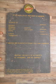
Chicago and Northwestern RY Green Bay, WI Roundhouse ChalkboardJM Hobby Supply and Railroad Artifact Auctions4.4(126)See Sold PriceFeb 24, 2024
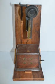
Rock Island RR Telephone from Silvis, IL ShopsJM Hobby Supply and Railroad Artifact Auctions4.4(126)See Sold PriceFeb 24, 2024
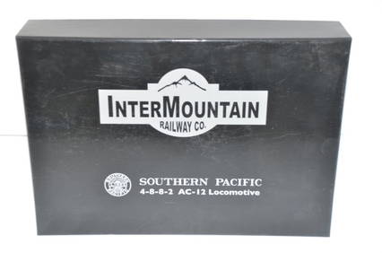
Southern Pacific RR 4-8-8-2 AC-12 DCC/Sound Steam Loco #4275-HO ScaleJM Hobby Supply and Railroad Artifact Auctions4.4(126)See Sold PriceFeb 25, 2024
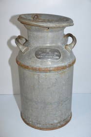
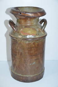
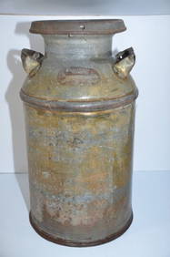
Rock Island RR Milk CanJM Hobby Supply and Railroad Artifact Auctions4.4(126)See Sold PriceFeb 24, 2024
Wabash RR Handlan Cast Globe Switchmans Lantern-Twist Off FountJM Hobby Supply and Railroad Artifact Auctions4.4(126)See Sold PriceFeb 24, 2024
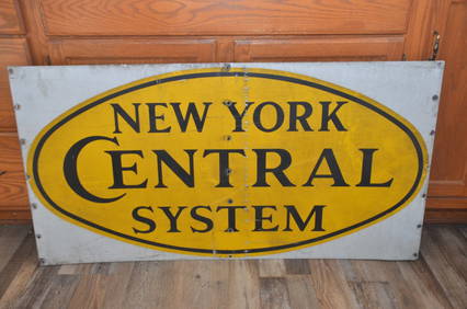
New York Central RR Hopper Car Metal Logo SignJM Hobby Supply and Railroad Artifact Auctions4.4(126)See Sold PriceFeb 24, 2024
C T Ham #3 Brass Conductors Lantern-Nickel PlatedJM Hobby Supply and Railroad Artifact Auctions4.4(126)See Sold PriceFeb 24, 2024
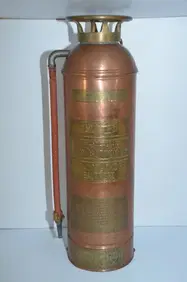
Baltimore and Ohio RR Tall Copper and Brass Fire Extinguisher-Double MarkedJM Hobby Supply and Railroad Artifact Auctions4.4(126)See Sold PriceFeb 24, 2024
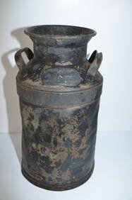
Chicago Burlington and Quincy RR Double Marked MIlk CanJM Hobby Supply and Railroad Artifact Auctions4.4(126)See Sold PriceFeb 24, 2024
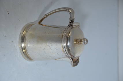
Chicago and Northwestern RR Silver TeapotJM Hobby Supply and Railroad Artifact Auctions4.4(126)See Sold PriceFeb 24, 2024
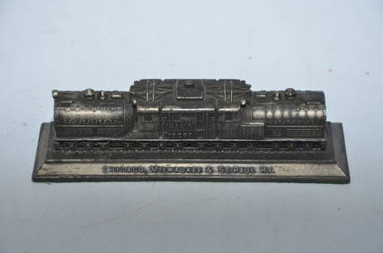
Chicago Milwaukee and St Paul RY Cast Bronze Bipolar Locomotive PaperweightJM Hobby Supply and Railroad Artifact Auctions4.4(126)See Sold PriceFeb 24, 2024
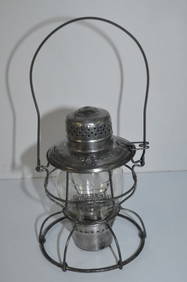
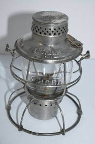
Illinois Central RR Handlan Lantern-Cast Two Sided GlobeJM Hobby Supply and Railroad Artifact Auctions4.4(126)See Sold PriceFeb 24, 2024
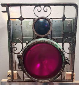
Pair of Chicago and Northwestern RY Flare and Flagging CansJM Hobby Supply and Railroad Artifact Auctions4.4(126)See Sold PriceFeb 24, 2024
Union Pacific RR Large Cream CanJM Hobby Supply and Railroad Artifact Auctions4.4(126)See Sold PriceFeb 24, 2024
Union Pacific RR Milk CanJM Hobby Supply and Railroad Artifact Auctions4.4(126)See Sold PriceFeb 24, 2024
Sold1836 Map of Durham Railway IllustratedA English county map of Durham circa 1860 with illustrations in the corners. Also marking railway stations. By tHomas Moule. Fine, light loss t lower left corner. Fine. Measures 10.5 x 8.5". Reserve:See Sold Price
SoldAPPLETON guides to the U.S. 2 vols. 1890APPLETON, Daniel and Company Appletons' General Guide to the United States and Canada. Illustrated with Railway Maps, Plans of Cities, and Table of Railway and Steamboat Fares. Part I. New England aSee Sold Price
Appleton's Guide to U.S. & Canada 1883Heading: Author: Appleton, D. and Company Title: Appletons' General Guide to the United States and Canada. Illustrated. With railway maps, plans of cities, and table of railway and steamboat fares PlSee Sold Price
SoldOriginal Travel Poster Channel Islands GuernseyOriginal vintage travel advertising poster for The Channel Islands - Go there by British Railways published by the Southern Region of British Railways. Colourful illustrated map of the Channel IslandsSee Sold Price
SoldOriginal Travel Poster A Map of Yorkshire BritishOriginal vintage travel poster A Map of Yorkshire issued by British Railways - Great illustrated map by Estra Clark (1904-1993) features a map of the English county Yorkshire with towns and cities coaSee Sold Price
Egyptian State Railways.Egyptian State Railways. Naples: Richter & Co., ca. 1930s. Lithograph map with railways highlighted in color, illustrated with oval halftones of notable Egyptian historic sites. 43 x 27". Handsome mahSee Sold Price
SoldTravel Poster Ireland Illustrated Pictorial Map British Railways BurleyOriginal vintage travel poster featuring a Map of Ireland produced by British Railways in co-operation with Bord Failte Eireann, the map shows places of note and interest, held with a frame depictingSee Sold Price
SoldLeonard, Zenas148. Leonard, Zenas.Leonard's Narrative. Adventures of Zenas Leonard Fur Trader and Trapper 1831-1836. Illustrated, including folding map. 8vo, gilt-lettered cloth; foxed, bookseller's clipping mounteSee Sold Price
SoldThrough Wonderland Yellowstone National Park Northern Pacific Railway Illustrated Book 1910Through Wonderland Yellowstone National Park illustrated book for the Northern Pacific Railway dated 1910. The 69 page soft bound booklet is illustrated with color and black & white photos and a map oSee Sold Price
SoldS.Indian Railway Co. Ltd. Illust.Guide,1913 +South Indian Railway Co. Ltd. Illustrated Guide,maps in pocket at end, Madras, 1913 § Thurston (Edgar) The Madras Presidency..., Cambridge, 1913 § Srnivas (M.N.) Religion and Society among theSee Sold Price
Sold1836 1st ed World As It Is Perkins Slavery Indians1836 1st ed World As It Is Perkins Slavery Indians Ireland Egypt Illustrated MAP ‘The World As It Is’ was written by Samuel Perkins to give a concise view of the nations of the world as it relatesSee Sold Price
Sold1836 Church History Marsh Jews Illustrated Color MAPS1836 Church History Marsh Jews Illustrated Color MAPS Pagans Pilgrims Quakers John Marsh was a minister of a church in Haddam, Connecticut in the late 18th and early 19th centuries. At Haddam, Marsh pSee Sold Price
SoldTravel Poster Northumberland Durham British RailwaysOriginal vintage British Railways travel poster featuring a map of Northumberland and Durham in the centre above a train with a compass point on the North Sea and descriptions of the historic county oSee Sold Price
The Canadian Rockies: New and Old TrailsAuthor: Coleman, A. P. 383 pp. Illustrated with a frontispiece and 30 photo plates, 1 single-page map, 3 folding maps (including folding Canadian Pacific Railway map printed in colors), original blueSee Sold Price
SoldRailway Guide.-Railway Guide.- Appletons' Illustrated Railway and Steam Navigation Guide..., large folding map and maps in the text, advertisements at beginning and end, original printed wrappers, browned, sSee Sold Price
SoldThe Canadian Rockies: New and Old TrailsAuthor: Coleman, A. P. Description: 383 pp. Illustrated with a frontispiece and 30 photo plates, 1 single-page map, 3 folding maps (including folding Canadian Pacific Railway map printed in colors), oSee Sold Price
SoldMeasom (George) The official illustrated guide toMeasom (George) The official illustrated guide to the Great Northern railway, folding map (slightly frayed), 1854 share certificate loosely inserted of Soc.Anon. des Chemins de Fer d'Anvers, cSee Sold Price
SoldOriginal Travel Poster Isle of Wight British RailwaysOriginal vintage travel poster for Isle of Wight issued by British Railways Southern Region - Great illustrated map artwork by Reginald Montague Lander (1913-1980) featuring colourful illustrations ofSee Sold Price
SoldCross (Joseph) - Cross's New Plan of London, 1836,from Canonbury to Camberwell, and from Hyde Park to East India Dock, updated to include the London and Birmingham railway, engraved map with full original hand-colouring, 665 x 1010mm., dissected andSee Sold Price
SoldPigot & Co (publishers). Map of Westmoreland showingPigot & Co (publishers). Map of Westmoreland showing turnpikes, canals, administrative areas, etc with a vignette of Kendal church, 19thC, also Durham, a slightly later map showing railway line, vigneSee Sold Price
SoldCounty of ESSEX. WRIGHT (Thomas) The History andCounty of ESSEX. WRIGHT (Thomas) The History and Topography of the County of Essex, illustrated by Bartlett, 2 vols., 2nd edition 1836, 4to, folding map, 100 plates, slight foxing, worn diced calf; [CSee Sold Price
SoldPigot & Co (publishers). Map of Westmoreland showingPigot & Co (publishers). Map of Westmoreland showing turnpikes, canals, administrative areas, etc with a vignette of Kendal church, 19thC, also Durham, a slightly later map showing railway line, vigneSee Sold Price
SoldGoodrich's school atlas 1836 - w/ 13 colored mapsTitle: Atlas, Designed to Illustrated the Malte-Brun School Geography Author: Goodrich, S[amuel] Griswold Description: With 13 hand-colored engraved map-sheets, 5 are double-page maps pertaining to thSee Sold Price
SoldBEATTIE, WILLIAM. SWITZERLAND ILLUSTRATED IN A SERBEATTIE, William. Switzerland Illustrated in a Series of Views Taken on the Spot, by W.H.Bartlett, in 2 volumes 1836, 4to, vignette titles, map and plates as listed, occasional spotting, half moroccoSee Sold Price
Crams Colored Railway Map and Shippers Guide of South Dakota 1908-1909JM Hobby Supply and Railroad Artifact Auctions4.4(126)See Sold PriceFeb 24, 2024
Early 1900's Railway Service Map, Illinois, Ohio, Indiana, Kentucky, TennesseeConnoisseur Auctions4(333)See Sold PriceFeb 24, 2024
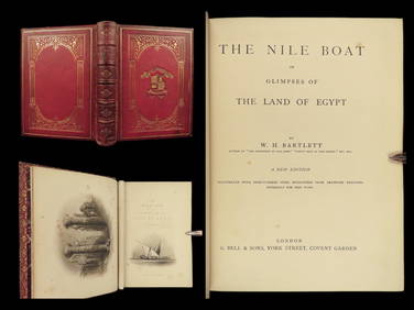
1880 Niles Boat Egypt Voyages Sphinx Pyramids Valley of Kings Illustrated MAPSSchilb Antiquarian Rare Books4.8(421)See Sold PriceMar 31, 2024
1887 Appletons' General Guide to the United State and Canada Part IIRail & Road Auctions4.6(165)See Sold PriceMar 08, 2024
Rand McNally & Co's New Ideal State and County Survey and Atlas 1911North American Artifact Auctions4.6(182)See Sold PriceApr 20, 2024
A "Fly TWA to Walt Disney's Magic Kingdom" Brochure.Van Eaton Galleries4.6(99)See Sold PriceMar 02, 2024
BACON'S ILLUSTRATED MAP OF YORKSHIRE 1876 BY EDWARD WELLER F.R.G.SHutchinson Scott Auctioneers4.4(39)See Sold PriceFeb 28, 2024
1738 BIBLE in DUTCH ILLUSTRATED w/ MAPS MASSIVE FOLIO in DUTCH antique BIBLIAJasper524.5(9.8k)See Sold PriceFeb 27, 2024
1744 ROMAN HISTORY ARMORIAL VELLUM BINDING ILLUSTRATED w/ MAP antique by FLORUSJasper524.5(9.8k)See Sold PriceFeb 27, 2024
1749-1771 HISTORY OF ROMAN EMPERORS 12 VOLUMES antique ILLUSTRATED w/ MAPSJasper524.5(9.8k)See Sold PriceFeb 27, 2024
1675 ELZEVIER JULIUS CAESAR antique ILLUSTRATED w/ MAPS ROMAN HISTORYJasper524.5(9.8k)See Sold PriceFeb 27, 2024
1711 GREEK BIBLE ILLUSTRATED w/ MAPS VELLUM BOUND antique NEW TESTAMENTJasper524.5(9.8k)See Sold PriceFeb 27, 2024
1738 BIBLE in DUTCH ILLUSTRATED w/ MAPS antique MASSIVE FOLIO BIBLIAJasper524.5(9.8k)See Sold PriceFeb 27, 2024
LESSING ROSENWALD COLLECTION of ANTIQUE BOOKS CATALOG illustratedJasper524.5(9.8k)See Sold PriceFeb 27, 2024
1709 GREEK BIBLE ILLUSTRATED w/ MAPS antique VELLUM BOUND Septuagint editionJasper524.5(9.8k)See Sold PriceFeb 27, 2024
INDIA WITHIN THE GANGES SUSAN GOLE ILLUSTRATED MAPS EARLY CARTOGRAPHYJasper524.5(9.8k)See Sold PriceFeb 27, 2024
1730 BIBLE in DUTCH ILLUSTRATED w/ MAPS antique MASSIVE FOLIO BIBLIAJasper524.5(9.8k)See Sold PriceFeb 27, 2024
1792 OLD INDIA HISTORY ANTIQUE ILLUSTRATED WITH MAPS OF THE EIGHTEENTH CENTURY IN FRENCHNY Elizabeth 4.3(84)See Sold PriceMar 03, 2024
1829 GERMAN-LANGUAGE ANTIQUE AMERICAN BIBLE ILLUSTRATED WITH MAPS OF PHILADELPHIANY Elizabeth 4.3(84)See Sold PriceMar 03, 2024
Helen Ledgwrlz - Illustrated map of the Cape Peninsula, South AfricaProverde Auctions4.3(3)See Sold PriceFeb 28, 2024
Colorful Illustrated Map - 1938 Southern California TourismProverde Auctions4.3(3)See Sold PriceFeb 28, 2024
Poster "Les jardins de Paris", illustrated map and plan of Paris with its parcs, gardens, monuments,Proverde Auctions4.3(3)See Sold PriceFeb 28, 2024