Sold1831 Baldwin & Craddock Atlas of Maps Ancient & Modern1831 Baldwin & Craddock Atlas of Maps Ancient & Modern – LondonSee Sold Price
Sold(Atlas Maps, World), Baldwin and Cradock, A Series(Atlas Maps, World), Baldwin and Cradock, A Series of Maps, Modern and Ancient, under the Superintendence of The Society for the Diffusion of Useful Knowledge, 1830-37, comprising twenty-four maps, isSee Sold Price
SoldJohn Frost, "History of Ancient and Modern Greece"John Frost, "History of Ancient and Modern Greece: Illustrated with Maps and Copperplate Engravings" (Boston, Lincoln and Edmands 1831); contemporary calf; First Edition, illustrated with 4 engravingsSee Sold Price
SoldBOOKS: (3) Vols Fine Leather Decorative BindingBOOKS: (3) Vols Fine Leather Decorative Binding, Three volumes: 1) Horatio Smith, Esq. Festivals, Games, and Amusements, Ancient and Modern.Henry Colburn and Richard Bentley, London. 1831. Hardcover.See Sold Price
SoldANCIENT EGYPT & Nile Valley. Ancient place names.Reserve Reduced! TITLE/CONTENT OF MAP: 'ANCIENT EGYPT' DATE PRINTED: This map was originally published by Baldwin & Cradock in 1831; this date is printed on the map. This edition of the map was printeSee Sold Price
Baldwin & Cradock / SDUK: Map of Ancient Egypt, 1831Ancient Egypt The fascinating and highly detaiiled ancient Egypt map from the SDUK atlas, with many geographical and historical notes, Cartographer: Baldwin & Cradock, Society for the Diffusion of UseSee Sold Price
Baldwin & Cradock/SDUK: Ancient EgyptMap Title: Ancient EgyptCartographer: Baldwin & Cradock, Society for the Diffusion of Useful Knowledge Place/Date: London / 1831/1852 Size: 11 7/8" x 14 1/8" Condition: b&w; overall age toning, some lSee Sold Price
Sold1828 ATLAS MAPS Ancient & Modern Geography Asia Africa1828 ATLAS MAPS Ancient & Modern Geography Asia Africa Turkey Greece Delamarche Felix Delamarche was a well-known and important French cartographer from the 18th-century. His best and most widely usedSee Sold Price
Atlas of Ancient and Modern HistoryTitle/Content of Map: Atlas of Ancient and Modern History; Date: 1845 Cartographer: [MITCHELL, SAMUEL AUGUSTUS] J.W. TYSON, A.B Publisher: S. AUGUSTUS MITCHELL Size: 13.5"H x 10.5"W presenting, in a cSee Sold Price
1807 Langlois World Atlas of Modern and Ancient Maps1807 Langlois World Atlas of Modern and Ancient Maps -- Nouvel Atlas Portatif Et Classique De Geographie Ancienne Et Moderne…. H. Langlois and Maps Based on J. D'anaville, 1807 Paris, 9.5 X 7.5 In.See Sold Price
Attica & Aegina, with ancient & modern names. Greece.TITLE/CONTENT OF MAP: 'Attica [with ancient and modern names]' DATE PRINTED: 1817 IMAGE SIZE: Approx 48.5 x 35.0cm, 19.25 x 13.75 inches (Large) TYPE: Antique early 19th century atlas map with originaSee Sold Price
"Attica" & Aegina, with ancient & modern names. Greece.TITLE/CONTENT OF MAP: 'Attica [with ancient and modern names]' DATE: 1817 IMAGE SIZE: Approx 48.5 x 35.0cm, 19.25 x 13.75 inches (Large) TYPE: Antique early 19th century atlas map with original hand cSee Sold Price
SoldRees (A.) The Cyclopaedia...Rees (A.) The Cyclopaedia...,plate vol. VI only: Ancient and Modern Atlas, engraved maps, recent half calf, 1820; and 3 others, 8vo & 4to; sold not subject to return.(4)See Sold Price
History of Ancient and Modern Wines-1824-Rare 1st Ed.Title: History of Ancient and Modern Wines-1824-Rare 1st Ed. Provenance: by Henderson, Al. About this Item: Baldwin, Craddock, and Joy, London, 1824. Hardcover. Condition: Very Good+. First Edition; FSee Sold Price
SoldC.1812 Cummings Ancient & Modern Geography BookMASSACHUSETTS, CIRCA 1812 The sixth edition of "An Introduction to Ancient and Modern Geography , On The Plan Of Goldsmith and Guy; Comprising Rules For Projecting Maps. With an Atlas" by J.A. CummingSee Sold Price
School Atlas to Cummings' Ancient & Modern Geography. Eighth EditionPublication Date: c1820 Title: School Atlas to Cummings' Ancient & Modern Geography. Eighth Edition Primary Authors: CUMMINGS, JACOB A Publisher: CUMMINGS AND HILLIARD Missouri in 1821 (not yet shownSee Sold Price
SoldBaldwin & Craddock: Map of Pompeii, 1832By: Baldwin & Craddock Date: 1832 (Published) London Dimensions: 12.5 x 15.5 inches (31.8 cm x 39.4) This elegant map of Pompeii was published in 1832 by the Society for the Diffusion of Useful KnowleSee Sold Price
SoldHAND COLORED ATLAS MAP BOOK 1821 M. CAREY & SONSAntique Atlas with hand coloring. Published by M. Carey & Sons, Philadelphia. Titled, "Ancient and Modern History of the Principal Royal Family. Leather corners and spine with some bends, some toningSee Sold Price
Large Map of Ancient & Modern Palestine - 19th CenturyFolding map of Palestine, Ancient and Modern. Made by A. Legendre based on maps of the Palestine Exploration Fund. Published by L. Thuillier. France, apparently circa the late 19th century. Mounted onSee Sold Price
Delaporte: Antique Map of Ancient & Modern Egypt, 1878Map: Ancient and Modern Egypt by Delaporte Date Printed: 1787 Cartographer: Joseph Delaporte Material/Medium: Paper Size: 7 3/4" x 9 3/4" Copperplate engraved. Geographiques Pour L'Intelligence Du VoySee Sold Price
1886 Adams Chronological Chart of Civilizations -- A Chronological Chart of Ancient, Modern andTitle: 1886 Adams Chronological Chart of Civilizations -- A Chronological Chart of Ancient, Modern and Biblical History Synchronized by Hon. Sebastian C. Adams with Maps of the World's Great Empires CSee Sold Price
L'Egitto Antico e Moderno. Ancient & modern Egypt.Reserve Reduced! TITLE/CONTENT OF MAP: 'L'Egitto Antico e Moderno' Ancient and modern Egypt DATE PRINTED: Published in 1785. Engraved in 1784 (this date is printed on the map). IMAGE SIZE: Approx 43.5See Sold Price
L'Egitto Antico e Moderno. Ancient & modern Egypt. ZATTA 1785 old mapTITLE/CONTENT OF MAP: 'L'Egitto Antico e Moderno' Ancient and modern Egypt DATE PRINTED: Published in 1785. Engraved in 1784 (this date is printed on the map). IMAGE SIZE: Approx 43.5 x 33.0cm, 17.25See Sold Price
SoldGeorge IV's Mapseller Extraordinary! BeautifullyGeorge IV of England King George IV's Mapseller Extraordinary! Beautifully Hand-colored Ancient & Modern World Atlas Two early nineteenth-century world atlases prepared by Charles Smith (flourished 18See Sold Price
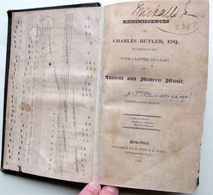
Charles Butler Ancient & Modern Music 1824 1st Edition Scarce MusicLuis Porretta Fine Arts4.3(10)See Sold PriceMar 02, 2024
[OCCULT]. BLAVATSKY, H.P. (1831 – 91). Isis Unveiled: A Mas...Potter & Potter Auctions4.6(545)See Sold PriceFeb 24, 2024
Medicine.- Kennedy (James) The History of the Contagious Cholera, first edition, 1831 & others (11)Forum Auctions4.3(53)See Sold PriceFeb 29, 2024
WEST AFRICA. British Cameroons & Togoland mandates. Gold Coast Nigeria 1947 mapJasper524.5(9.9k)See Sold PriceFeb 28, 2024
CAP VERT. French/Portuguese Guinea Gambia Senegal Sierra Leone 1947 old mapJasper524.5(9.9k)See Sold PriceFeb 28, 2024
Algeria Morocco & Tunis. North Africa. Tunisia. Maghreb. BARTHOLOMEW 1898 mapJasper524.5(9.9k)See Sold PriceFeb 28, 2024
North-west Africa. Morocco &c. Sahara desert. Unresolved borders. TIMES 1922 mapJasper524.5(9.9k)See Sold PriceFeb 28, 2024
Carte d'Afrique. Africa Soudan Zanzibar. LAPIE 1831 old antique map plan chartJasper524.5(9.9k)See Sold PriceFeb 28, 2024
Colonial & French West Africa. Gold Coast Dahomey Upper Volta. TIMES 1922 mapJasper524.5(9.9k)See Sold PriceFeb 28, 2024
North & West Africa. Dahomey. Gold Coast. Military Territory. THE TIMES 1922 mapJasper524.5(9.9k)See Sold PriceFeb 28, 2024
Colonial Africa North-West. British French. Nigeria Sahara. THE TIMES 1895 mapJasper524.5(9.9k)See Sold PriceFeb 28, 2024
Colonial Africa North-East. Hejaz Kenya Abyssinia Sudan. THE TIMES 1895 mapJasper524.5(9.9k)See Sold PriceFeb 28, 2024
Colonial West Africa. Nigeria Cameroon Congo. British German. TIMES 1900 mapJasper524.5(9.9k)See Sold PriceFeb 28, 2024
Colonial Africa North-East. Hejaz Kenya Abyssinia Colonial. THE TIMES 1900 mapJasper524.5(9.9k)See Sold PriceFeb 28, 2024
Afrique Ancienne. Ancient North Africa. MALTE-BRUN c1871 old antique map chartJasper524.5(9.9k)See Sold PriceFeb 28, 2024
Colonial West Africa. Nigeria Cameroon Congo. British German. TIMES 1895 mapJasper524.5(9.9k)See Sold PriceFeb 28, 2024
Colonial Africa North-West. British French. Nigeria Sahara. THE TIMES 1900 mapJasper524.5(9.9k)See Sold PriceFeb 28, 2024
Jan Goeree (1670-1731) - Set of 2 Italian Engravings of Roman ScenesProverde Auctions4.3(3)See Sold PriceFeb 28, 2024
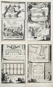
Jan Goeree (1670-1731) - Set av 4 Architecture Engravings - Church of Saint Pudentiana - AProverde Auctions4.3(3)See Sold PriceFeb 28, 2024
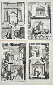
Jan Goeree (1670-1731) - Set av 4 Architecture Engravings - A Reconstruction of the Arch of DomitianProverde Auctions4.3(3)See Sold PriceFeb 28, 2024


![[OCCULT]. BLAVATSKY, H.P. (1831 – 91). Isis Unveiled: A Mas... (1 of 3)](https://p1.liveauctioneers.com/928/317913/170625569_1_x.jpg?height=282&quality=70&version=1706650066)