ATLAS of ANTIENT GEOGRAPHY by SAMUEL BUTLER 1843John McInnis Auctioneers,LLC4.5(505)See Sold PriceFeb 24, 2024
18TH C. ANTIQUE MAP: FRENCH & INDIAN WAR, FRAMEDThomaston Place Auction Galleries4.4(393)See Sold PriceFeb 24, 2024
Rand McNally Railroad Map Cabinet w/ 21 Railroad MapsRail & Road Auctions4.6(165)See Sold PriceMar 08, 2024
Keith Haring - Ink on New York Map, Best Buddies, Inscribed, Signed, and DatedSapphire Auction Gallery4(67)See Sold PriceMar 02, 2024
LATE 17TH C. FRENCH MAP OF THE NEW WORLD BY ALEXIS-HUBERT JAILLOT (1632-1712)Thomaston Place Auction Galleries4.4(393)See Sold PriceFeb 24, 2024
Central Railroad of New Jersey Map of Sandy Hook Route-ca. 1903JM Hobby Supply and Railroad Artifact Auctions4.4(127)See Sold PriceFeb 24, 2024
Lot of Six Mixed Atlas Box Cars-HO Scale-New in BoxJM Hobby Supply and Railroad Artifact Auctions4.4(127)See Sold PriceFeb 25, 2024
Rand McNally/Santa Fe Railroad Map of Iowa-1912JM Hobby Supply and Railroad Artifact Auctions4.4(127)See Sold PriceFeb 24, 2024
NICOLAES VISSCHER (NETHERLANDS, 1618-1709) MAP OF THE NEW WORLDThomaston Place Auction Galleries4.4(393)See Sold PriceFeb 24, 2024
17TH C. WORLD MAP BY NICOLAES VISSCHER (NETHERLANDS, 1618-1709)Thomaston Place Auction Galleries4.4(393)See Sold PriceFeb 24, 2024
Lot of Six Mixed Atlas Cabooses-HO Scale-New in BoxJM Hobby Supply and Railroad Artifact Auctions4.4(127)See Sold PriceFeb 25, 2024
Sold1825 Carte Geographique, Statistique et Historique LeBy: Jean Alexandre BuchonDate: 1825 (Published) ParisDimensions: 18.5 x 25 inches (47 cm x 64 cm)This antique map is a rare example by Buchon depicting the state of Ohio by itself, rather than togetheSee Sold Price
Sold1825 Carte Geographique, Statistique et HistoriqueBy: Jean Alexandre BuchonDate: 1825 (Published) ParisDimensions: 18.5 x 25 inches (47 cm x 64 cm)This antique map is a rare example by Buchon depicting the state of North Carolina by itself, rather thSee Sold Price
Sold1825 Carte Geographique, Statistique et Historique DuBy: Jean Alexandre BuchonDate: 1825 (Published) ParisDimensions: 18.5 x 25 inches (47 cm x 64 cm)This antique map is a rare example by Buchon depicting the state of Tennessee by itself, rather than toSee Sold Price
Sold1825 Carte Geographique, Statistique et Historique DeBy: Jean Alexandre BuchonDate: 1825 (Published) ParisDimensions: 18.5 x 25 inches (47 cm x 64 cm)This antique map is a rare example by Buchon depicting the state of Pennsylvania by itself, rather thanSee Sold Price
Sold1825 Carte Geographique, Statistique et Historique DuBy: Jean Alexandre BuchonDate: 1825 (Published) ParisDimensions: 18.5 x 25 inches (47 cm x 64 cm)This antique map is a rare example by Buchon depicting the state of Rhde Island by itself, rather thanSee Sold Price
Sold1825 Carte Geographique, Statistique et Historique DuBy: Jean Alexandre BuchonDate: 1825 (Published) ParisDimensions: 18 x 24 inches (46 cm x 61 cm)This handsome antique map by Buchon depicts Brazil and what was known of it to Westerners in 1825. The coSee Sold Price
Sold1825 Carte Geographique, Statistique et Historique DuBy: Jean Alexandre BuchonDate: 1825 (published) Paris.Dimensions: 17 x 24 inches (43.18 x 61 cm).This is an authentic antique map of Washington D.C., by Jean Alexandre Buchon. The map is from the FrenSee Sold Price
Sold1825 Carte Geographique, Statistique et Historique DuBy: Jean Alexandre BuchonDate: 1825 (Published) ParisDimensions: 18.5 x 25 inches (47 cm x 64 cm)This antique map is a rare example by Buchon depicting the state of Alabama by itself, rather than togeSee Sold Price
1825 Carte Geographique, Statistique et Historique DuBy: Jean Alexandre BuchonDate: 1825 (Published) ParisDimensions: 18.5 x 25 inches (47 cm x 64 cm)This antique map is a rare example by Buchon depicting the state of Vermont by itself, rather than togeSee Sold Price
Sold1825 Carte Geographique, Statistique et Historique DuBy: Jean Alexandre BuchonDate: 1825 (Published) ParisDimensions: 18.5 x 25 inches (47 cm x 64 cm)This antique map is a rare example by Buchon depicting the state of Maryland by itself, rather than togSee Sold Price
Sold1825 Carte Geographique, Statistique et Historique DeBy: Jean Alexandre BuchonDate: 1825 (published) ParisDimensions: 18.25 x 24 inches (46.35 x 60.95 cm)This is an authentic antique map of Florida with portions of the Bahamas and Cuba, by Jean AlexandrSee Sold Price
Sold1825 Carte Geographique, Statistique et Historique DuBy: Jean Alexandre BuchonDate: 1825 (Published) ParisDimensions: 18.5 x 25 inches (47 cm x 64 cm)This antique map is a rare example by Buchon depicting the state of Kentucky by itself, rather than togSee Sold Price
Sold1825 Carte Geographique, Statistique et Historique DeBy: Jean Alexandre BuchonDate: 1825 (Published) ParisDimensions: 18.5 x 25 inches (47 cm x 64 cm)This antique map is a rare example by Buchon depicting the state of South Carolina by itself, rather thSee Sold Price
1825 Carte Geographique, Statistique et Historique DeThis antique map is a rare example by Buchon depicting the state of South Carolina in and of itself, rather than together with adjoining states. Buchon based his work on Carey & Lea's famous 1822-3, "See Sold Price
1825 Carte Geographique, Statistique et HistoriqueBy: Jean Alexandre BuchonDate: 1825 (Published) ParisDimensions: 18.5 x 25 inches (47 cm x 64 cm)This antique map is a rare example by Buchon depicting the state of Illinois by itself, rather than togSee Sold Price
Sold1825 Carte Geographique, Statistique et Historique DuBy: Jean Alexandre BuchonDate: 1825 (Published) ParisDimensions: 18 x 24 inches (46 cm x 61 cm)This antique map is a rare example by Buchon depicting the state of Delaware in and of itself, rather thaSee Sold Price
1825 Carte Geographique, Statistique Et Historique De1825 Carte Geographique, Statistique Et Historique De L’Amerique SeptentrionaleSee Sold Price
1825 Carte Geographique, Statistique et Historique DuThis antique map is a rare example by Buchon depicting the state of Kentucky in and of itself, rather than together with adjoining states. Buchon based his work on Carey & Lea's famous 1822-3, "A compSee Sold Price
1825 Carte Geographique, Statistique Et Historique De1825 Carte Geographique, Statistique Et Historique De L’Amerique SeptentrionaleSee Sold Price
1825 Carte Geographique, Statistique et Historique DuThis antique map is a rare example by Buchon depicting the state of Tennessee in and of itself, rather than together with adjoining states. Buchon based his work on Carey & Lea's famous 1822-3, "A comSee Sold Price
1825 Carte Geographique, Statistique et HistoriqueThis antique map is a rare example by Buchon depicting the state of Alabama in and of itself, rather than together with adjoining states. Buchon based his work on Carey & Lea's famous 1822-3, "A complSee Sold Price
Sold1825 Carte Geographique, Statistique et Historique DuBy: Jean Alexandre BuchonDate: 1825 (Published) ParisDimensions: 17 x 24 inches (43.18 cm x 60.96 cm)This is an authentic, antique map which was created by Jean Alexandre Buchon in 1825 and publishedSee Sold Price
Sold1825 Carte Geographique, Statistique et Historique DuBy: Jean Alexandre BuchonDate: 1825 (Published) ParisDimensions: 18.5 x 25 inches (47 cm x 64 cm)This antique map is a rare example by Buchon depicting the state of New York by itself, rather than togSee Sold Price
Sold1825 Carte Geographique, Statistique et Historique DeBy: Jean Alexandre BuchonDate: 1825 (Published) ParisDimensions: 18.5 x 25 inches (47 cm x 64 cm)This antique map is a rare example by Buchon depicting the state of New Hampshire by itself, rather thaSee Sold Price
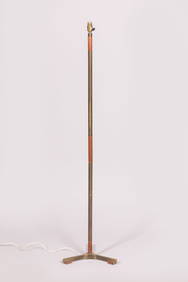
Jo HAMMERBORG (attribué à) : Lampadaire tripode en laiton et métal doré, les pieds et le fûtValoir Pousse-Cornet4.3(4)See Sold PriceFeb 24, 2024
Marc Chagall La feerie et le royaume (The Fairy and the Kingdom) 6th of 10 worksMynt Auctions4.6(697)See Sold PriceFeb 23, 2024
LOUIS XIV (1643-1715, roi de France 1651-1715) – 1702IEGOR Auctions4.2(135)See Sold PriceFeb 28, 2024
Map of St. Kitts and Nevis Depot de la Marine, Paris, 1758Global Auctions Company4.3(36)See Sold PriceMar 03, 2024
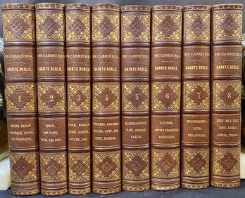
SAINTE BIBLE CONTENANT L’ANCIEN ET LE NOUVEAU TESTAMENT, PAR LE R.P. DE CARRIERES, 8 VOLUMES, 1862The Rug Life4.3(13)See Sold PriceMar 07, 2024
After Urrabietta, Late 19th century, Lithographs, Two lithographs with examples of RussianClaydon Auctioneers Ltd4.3(125)See Sold PriceFeb 26, 2024
1758 MAP PARTIE DE LA MER GLACIALE contenants La Nouvelle Zemble RUSSIA antiqueJasper524.5(9.9k)See Sold PriceFeb 27, 2024
1764 Bellin Map of Antigua -- Carte de l'Isle d'Antigue Situee par la Latitude 17 Degres et par laJasper524.5(9.9k)See Sold PriceFeb 27, 2024
1764 Bellin Chart of Three South Haitian Bays -- Carte des Bayes du Mesle des Flamands et deJasper524.5(9.9k)See Sold PriceFeb 27, 2024
Carte du Golfe de Guinée'. Gulf of Guinea. Nigeria & Cameroon. BELLIN 1747 mapJasper524.5(9.9k)See Sold PriceFeb 28, 2024
Carte de la Guinée, contenant…'. Guinea & Cape Verde islands. BONNE 1771 mapJasper524.5(9.9k)See Sold PriceFeb 28, 2024
Carte du Golfe de Guinée. Gulf of Guinea Nigeria Cameroon BELLIN/SCHLEY 1748 mapJasper524.5(9.9k)See Sold PriceFeb 28, 2024