ATLAS of ANTIENT GEOGRAPHY by SAMUEL BUTLER 1843John McInnis Auctioneers,LLC4.6(504)See Sold PriceFeb 24, 2024
18TH C. ANTIQUE MAP: FRENCH & INDIAN WAR, FRAMEDThomaston Place Auction Galleries4.4(389)See Sold PriceFeb 24, 2024
Rand McNally Railroad Map Cabinet w/ 21 Railroad MapsRail & Road Auctions4.6(165)See Sold PriceMar 08, 2024
Keith Haring - Ink on New York Map, Best Buddies, Inscribed, Signed, and DatedSapphire Auction Gallery4.1(67)See Sold PriceMar 02, 2024
LATE 17TH C. FRENCH MAP OF THE NEW WORLD BY ALEXIS-HUBERT JAILLOT (1632-1712)Thomaston Place Auction Galleries4.4(389)See Sold PriceFeb 24, 2024
Central Railroad of New Jersey Map of Sandy Hook Route-ca. 1903JM Hobby Supply and Railroad Artifact Auctions4.4(126)See Sold PriceFeb 24, 2024
Lot of Six Mixed Atlas Box Cars-HO Scale-New in BoxJM Hobby Supply and Railroad Artifact Auctions4.4(126)See Sold PriceFeb 25, 2024
Rand McNally/Santa Fe Railroad Map of Iowa-1912JM Hobby Supply and Railroad Artifact Auctions4.4(126)See Sold PriceFeb 24, 2024
NICOLAES VISSCHER (NETHERLANDS, 1618-1709) MAP OF THE NEW WORLDThomaston Place Auction Galleries4.4(389)See Sold PriceFeb 24, 2024
17TH C. WORLD MAP BY NICOLAES VISSCHER (NETHERLANDS, 1618-1709)Thomaston Place Auction Galleries4.4(389)See Sold PriceFeb 24, 2024
Lot of Six Mixed Atlas Cabooses-HO Scale-New in BoxJM Hobby Supply and Railroad Artifact Auctions4.4(126)See Sold PriceFeb 25, 2024
1814 Carey Map Of New Jersey1814 Carey Map Of New Jersey -- The State Of New Jersey Compiled From The Most Authentic Information, M Carey / S Lewis, 1814, Philadelphia, 17 x 11.8 in. A quite handsome New Jersey topographical mapSee Sold Price
SoldCarey: Antique Map of New Jersey, 1814Map: 1814 Carey Map of New Jersey -- The State of New Jersey Compiled from the most Authentic Information Date Printed: 1814, Philadelphia Cartographer: M Carey / S Lewis Size: 17 x 11.8 in. ConditionSee Sold Price
Carey: Map of New Jersey, 1814Map: 1814 Carey Map of New Jersey -- The State of New Jersey Compiled from the most Authentic Information Cartographer: M Carey / S Lewis Year / Place: 1814, Philadelphia Map Dimensions: 17 x 11.8 in.See Sold Price
Carey: Antique Map of New Jersey, 1814Map: 1814 Carey Map of New Jersey -- The State of New Jersey Compiled from the most Authentic Information Cartographer: M Carey / S Lewis Year / Place: 1814, Philadelphia Map Dimensions: 17 x 11.8 in.See Sold Price
1814 Carey Antique Map of New JerseyTitle/Content of Map: 1814 Map of New Jersey -- The State of New Jersey, Compiled from the Most Authentic Information Date Printed: 1814, Philadelphia Cartographer: M Carey Size: 18.5 x 13 in. A ratheSee Sold Price
1814 Carey Antique Map of New JerseyTitle/Content of Map: 1814 Map of New Jersey -- The State of New Jersey, Compiled from the Most Authentic Information Date Printed: 1814, Philadelphia Cartographer: M Carey Size: 18.5 x 13 in. A ratheSee Sold Price
Carey: Map of New Jersey, 1814Map: 1814 Map of New Jersey -- The State of New Jersey, Compiled from the Most Authentic Information Cartographer: M Carey Year/Place: 1814, Philadelphia Dimensions: 18.5 x 13 in. A rather attractiveSee Sold Price
Carey: Antique Map of New Jersey, 1814Title/Content of Map: 1814 Map of New Jersey -- The State of New Jersey, Compiled from the Most Authentic Information Date Printed: 1814, Philadelphia Cartographer: M Carey Size: 18.5 x 13 in. A ratheSee Sold Price
SoldFramed map of the state of New Jersey compiled from theFramed map of the state of New Jersey compiled from the most authentic information, compiled by Samuel Lewis. From Carey's General Atlas, 1814. The first atlas made in the United States to employ stanSee Sold Price
Sold1814 Map of New Jersey -- The State of New Jersey,Title/Content of Map: 1814 Map of New Jersey -- The State of New Jersey, Compiled from the Most Authentic Information Date: 1814, Philadelphia Cartographer: M Carey Size: 18.5 x 13 in. A rather attracSee Sold Price
Extremely scarce 1814 Mathew Carey map of New YorkHighly desirable and collectible War of 1812-era map of New York by Samuel Lewis. From a very scarce 1816 edition of Carey’s General Atlas (same map as the 1814 atlas). Map is colored by countieSee Sold Price
Map of New York, by Matthew Carey, 1814, Museum FramingBeautiful map of New York from Carey' General Atlas, published by Matthew Carey in Philadelphia, 1814. Map features counties and shows towns, roads, rivers, lakes, mountains, etc. Museum FramingSee Sold Price
Sold5 Framed Antique Maps of New JerseyLot includes: F. Lucas Jr, The State of New Jersey Compiled by the most Authentic information (Carey's American Edition of Guthries Geography Improved), New Jersey by A Finley, A Plan of the northernSee Sold Price
Sold5 Framed Antique Maps of New JerseyLot includes: F. Lucas Jr, The State of New Jersey Compiled by the most Authentic information (Carey's American Edition of Guthries Geography Improved), New Jersey by A Finley, A Plan of the northernSee Sold Price
SoldJohn Carey. North America map(English, 1754-1835). "Part of North America comprehending Ohio, New England, New York, New Jersey, Pennsylvania, Maryland, Virginia, Carolinas & Georgia" (sic) hand colored map, circa 1782, 9 1/2 x 1See Sold Price
Buchon: Encyclopedic Map of 1820s New JerseyReserve Reduced! The New Jersey sheet from the Atlas Geographique, Statistique, Historique, et Cronologique des Deux Ameriques, the French version of Carey & Lea's American Atlas, published in Paris bSee Sold Price
Map of the State of New Jersey, 1814Map: The State of New Jersey, Compiled from the Most Authentic Information Cartographer: M Carey Date: 1814 Origin: Philadelphia Size: 18.5 x 13 inches A rather attractive topographical map of New JerSee Sold Price
Sold5 American Maps c. 1795: Carey, LewisFive (5) 18th century Maps by Samuel Lewis: Maine, Massachusetts, Pennsylvania, New York and New Jersey, from The General Atlas for CareyÕs Edition of GuthrieÕs Geography Improved. Note: The GeneralSee Sold Price
Sold1795 map of the State of New Jersey1795 map "The State of New Jersey" from Mathew Carey's American Atlas, compiled by Samuel Lewis, engraved by W Baker, two sheet, original outline hand coloring, some staining, 21 1/2" x 17"See Sold Price
Ext. scarce 1814 map of British Possessions, M. CareyEssentially the second edition of this map, the first being from Carey’s 1795 atlas. The map was redrawn with new information for the 1814 Carey General Atlas. This example comes from his 1816 GSee Sold Price
New JerseyTitle/Content of Map: New Jersey Date: 1814 Cartographer: CAREY, MATHEW/A. DOOLITTLE Size: 7.75X5.75 From the 4th edition of Carey's American Pocket Atlas. With text. Browned. Please note that this loSee Sold Price
SoldMap of The State of New Jersey. compiled by SamuelMap of The State of New Jersey. compiled by Samuel Lewis. "Engraved for Carey's American Edition of Guthrie's Geography improved" appx. 1" tear along edge of center fold. browning. ss: 18"h x 12"wSee Sold Price
Ophthalmology Print, 1890Beautiful map of New York from Carey' General Atlas, published by Matthew Carey in Philadelphia, 1814. Map features counties and shows towns, roads, rivers, lakes, mountains, etc. Museum FramingSee Sold Price
SoldNew South Wales Australia 1814Heading: (Map) Author: Carey, Mathew Title: A New and Accurate Map of New South Wales with Norfolk and Lord Howe's Islands, Port Jackson &c. from Actual Surveys Place Published: Philadelphia PublisherSee Sold Price
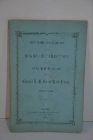
Central Railroad of New Jersey 13th Annual Report-January 1, 1860JM Hobby Supply and Railroad Artifact Auctions4.4(126)See Sold PriceFeb 24, 2024
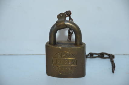
New Jersey Central RR Maintenance of Way LockJM Hobby Supply and Railroad Artifact Auctions4.4(126)See Sold PriceFeb 24, 2024
Central Railroad of New Jersey Map of Sandy Hook Route-ca. 1903JM Hobby Supply and Railroad Artifact Auctions4.4(126)See Sold PriceFeb 24, 2024
Group of Ten Railroad Photographs, Maps, and Prints - New Jersey, Long Island, and New YorkRail & Road Auctions4.6(165)See Sold PriceMar 07, 2024
A Fine Violin Made by Joseph A. Walter Violin Montclair New Jersey 1949P.K. Gallery4.5(35)See Sold PriceFeb 25, 2024
BRANCHVILLE, NEW JERSEY TRAIN STATION O/BHartzell's Auction Gallery, Inc.4.7(1.2k)See Sold PriceMar 03, 2024
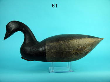
TWO NEW JERSEY DECOYS Early 20th Century Lengths 14" and 16".Eldred's4.7(418)See Sold PriceMar 07, 2024
Clarke & Neele 1815 Map. Europe - Recent Political ChangesAlbion Auctions4.6(341)See Sold PriceMar 01, 2024
New Jersey Bell Telephone Company Public Telephone Porcelain SignMatthew Bullock Auctioneers4.7(1.8k)See Sold PriceMar 02, 2024
BLACK-BREASTED PLOVER, NEW JERSEYFrank and Frank Sporting Collectibles LLC4.7(166)See Sold PriceMar 10, 2024
EARLY SHOREBIRD, NEW JERSEYFrank and Frank Sporting Collectibles LLC4.7(166)See Sold PriceMar 10, 2024