Sold17th century map of Italy,[Stato Della Chiesa, Con la Toscana. Herschaffen der Kom: Kirchen and Groshertzogthumb Florentz", by Matthaus Merian, Frankfurt, 1695, after Blaeu's map of the same region, detailed map with ornate tiSee Sold Price
SoldJansson Terra di Bari et Basilicata Mid 17th C.[Jansson (Jan)] Terra di Bari et Basilicata, circa mid 17th century. Map of Italy. Map titled "Terra di Bari et Basilicata". Information on the region on verso. Measures 23.25" x 19.5" sheet size. UnfSee Sold Price
SoldJansson Terra di Bari et Basilicata Mid 17th C.[Jansson (Jan)] Terra di Bari et Basilicata, circa mid 17th century. Map of Italy. Map titled "Terra di Bari et Basilicata". Information on the region on verso. Measures 23.25" x 19.5" sheet size. UnfSee Sold Price
Blaeu: Antique Map of Italy & Islands, 1635Title: "Nova Italiae Delineatio", Beautiful mid-17th century hand-colored map of Italy and surrounding islands Map maker: Willem Janszoon Blaeu Place and Year: Amsterdam, c. 1635 Dimensions: 51.0 x 59See Sold Price
SoldPlanisfero del Mondo Nuovo, Descritto…Vincenzo Coronelli (1650 – 1718). Venice, 1691, 20 x 28 inches. Italy’s Greatest 17th Century Map Maker. A very fine map of the Western Hemisphere including the discoveries made by Abel Tasman inSee Sold Price
A rare Dutch map of Flanders by Petrus Kaerius,A rare Dutch map of Flanders by Petrus Kaerius, untitled, with inset reading ‘Habes hic Novam & Accuratissimam Descriptionem Tractus (…)’, 17th century, together with a map of South-East Italy bSee Sold Price
SoldEurope.- Mixed group of 17th and 18th century mapsEurope.- Mixed group of 17th and 18th century maps,regions in France and Italy and the counties of Hereford, Hampshire and Berkshire, engraved maps, two with hand-colouring, v.s., average 180See Sold Price
SoldJan Janssonius Mid 17th Century Map of Amsterdam21" x 15 1/2" in a thin wood frame, Jan Janssonius (1588-1664) Dutch cartographer, he produced his first maps 1616 of France and Italy. This hand colored map of Amsterdam is now framed, it was foldedSee Sold Price
SoldFramed 17th C. Map of Italy by Henricus Hondius.FRAMED 17TH CENTURY MAP, Neopolitan Regnum, published by Henricus Hondius of Amsterdam. Map of southern Italy. Three inch separation bottom centter, lighter band top to bottom center. Frame H: 22 1/8"See Sold Price
SoldWillem Blaeu: Map of Napoli, ItalyMid 17th Century Map on Chain lined paper. Hand colored Map reads: Regno Di Napoli, and bears hand colored family crests around the border. This map is framed under glass and has not been inspected ouSee Sold Price
SoldLate 17th Century Map of GreeceCopper plate engraving map of Greece titled "Graeciae Antiquae Tabula Geographica" by Nicolas Sanson (1600-1667) and engraved in Padua, Italy in 1694 by F.Bertin and produced under the auspices of theSee Sold Price
Sold1685 H/C Map of London by Vincenzo Maria CoronelliRare 17th Century Map of London, England - Vincenzo Maria Coronelli in Venice, Italy circa 1685 - Beautiful Original Hand-Colored Engraved Map of London, England | Very Scarce Map Created in 1685 duriSee Sold Price
SoldMONTEGRAPPA Sterling Silver GEA Ltd FPHeading: Author: Montegrappa Title: Gea Sterling Silver Limited Edition Fountain Pen Place Published: Italy Publisher: Date Published: 2001 Description: Inspired by a 17tSee Sold Price
de Wit: Antique Dutch Map of Italy, 1680Title: Novissima et Accuratissima totius Italiae Corsicae et Sardiniae Descriptio. Lovely 17th century Dutch map of Italy Map maker: Frederick de Wit Place and Year: Amsterdam, c. 1680 Dimensions: 56.See Sold Price
SoldGrp: 13 Maps of Italy and from Munster's CosmograGroup of 17th-19th century maps. This lot includes four pages from Sebastian Munster's "Cosmographia" including a map of Elba, a map of Italian mainland cities, a map of Sicily, and a map of Africa. TSee Sold Price
Soldmap, ancient Italy, Jan JanssonFramed map of ancient Italy, ''Italia Antiqua Philippo Cluvero Borusso Designatore,'' 17th century, by Jan Jansson (Dutch, 1588-1644), from ''Atlas'' by G. Mercator, published by Jodocus Hondius, haviSee Sold Price
SoldMercator Map of Northern ItalyMercator Map of Northern Italy "Veronae Vicentiae Et Patavii Ditiones," by Gerardus Mercator (1562 - 1594), a posthumous 17th century edition, highly detailed hand-colored engraving showing the regionSee Sold Price
Sold17TH C. DUTCH MAP OF UMBRIA, ITALYMARCA D’ANCONA olim PICENUM, Parte des Umbria map, 16.5 by 20.75 in. (sight), matted, framed under glass on reverse: ‘Joannes Jansson, Dutch, 17th century Marca D’ANCONA olim Picenum, circa 1650See Sold Price
Sold1759 Geography 18 Maps ATLAS Africa Italy Asia America1759 Geography 18 Maps ATLAS Africa Italy Asia America California Island Buffier Known primarily for his contributions to philosophy, Claude Buffier, a 17th-century French Jesuit historian, publishedSee Sold Price
Sold(2) antique hand-colored maps: Italy: Verona, Veni(2) antique hand-colored maps: Italy: Verona, Venice, 17th and 18th century, incl. Sanson, larger: 21.5" x 23.5", unframedSee Sold Price
Sold17th/18th map, Horowitz estateEarly black and white map, 17th/18th century. From the Milton Horowitz estate. Showing the coast of Italy. Map: 20"x 14.5" in a frame: 26.5"x 21".See Sold Price
SoldEarly Hand-Colored Map of VeniceItaly, ca. 16th-17th century. Fine hand-colored engraved map of "Venetia" with boats in harbor and compass rose. Handsomely framed. MEASUREMENTS Sight wide: 5 7/8 / 15 cm. Sight height: 4 1/2 / 11.5 cSee Sold Price
SoldMap, "Abruzzo Citra et Ultra", 17th CenturyMap, "Abruzzo Citra et Ultra",detailed map of the feudal state of Abruzzo, a region in Italy, East of Rome , margins are as is, some soiling, 20.5" by 24"See Sold Price
SoldAn ancient map of the Lazio regiondating: late 17th Century provenance: Italy, A colored print depicting the map of the Lazio region; at the top, on the right side, a painting of gods and trophies, marked 'Il Lazio con le sue più CSee Sold Price
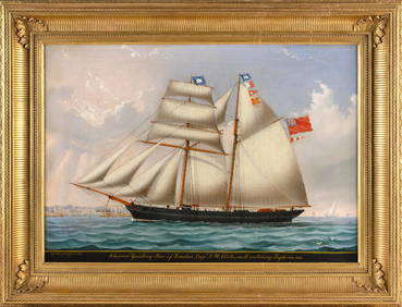
LUIGI P. RENAULT (Italy, 1845-c.1910), "Schooner 'Guiding Light' of London, Captn. J.H. Wetherall,Eldred's4.7(409)See Sold PriceFeb 28, 2024
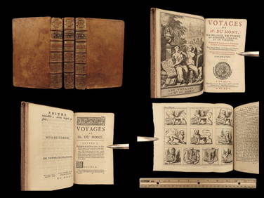
1699 Jean Dumont VOYAGES in France Italy Germany ROME Malta Turkey Ottoman 3vSchilb Antiquarian Rare Books4.8(421)See Sold PriceMar 31, 2024
17th Century Hand Colored Engraved Map of GermanyGlobal Auctions Company4.3(36)See Sold PriceMar 03, 2024
Willem Blaeu, Etc. 17th C. Antiquarian Maps, 2Auctions at Showplace4.5(726)See Sold PriceMar 17, 2024
Saint Cecilia on copper, Italy, 17th centuryTemplum Fine Art Auctions4.3(8)See Sold PriceFeb 28, 2024
The dream of Saint Joseph in copper oval Italy or Portugal 17th centuryTemplum Fine Art Auctions4.3(8)See Sold PriceFeb 28, 2024
Large Italian Baroque Bishop of the 17th century, Italy, RomeTemplum Fine Art Auctions4.3(8)See Sold PriceFeb 28, 2024
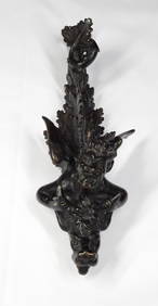
Rare and very beautiful Bronze Door Knocker from ITALY, 16/17th CenturyBasel Auction House4.4(43)See Sold PriceFeb 24, 2024
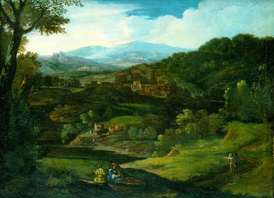
ATTRIBUTED TO PHILIPP PETER ROOS/ROSA DA TIVOLI (C.1655/57-1706) "PASTORAL LANDSCAPE".Amelia Jeffers, Auctioneers & Appraisers4.6(101)See Sold PriceMar 07, 2024
WEST AFRICA Niger/Gambia rivers tribes towns. 'Pays des Negres'. MALLET 1683 mapJasper524.5(9.8k)See Sold PriceFeb 28, 2024
WEST AFRICA. Guinea. Nigeria Ghana Benin Togo Sierra Leone. MALLET 1683 mapJasper524.5(9.8k)See Sold PriceFeb 28, 2024
WEST CENTRAL AFRICA. Congo Angola Gabon Cameroon Sao Tome. MALLET 1683 old mapJasper524.5(9.8k)See Sold PriceFeb 28, 2024
NORTH AFRICA. 'Biledulgerid', a former North African country. MALLET 1683 mapJasper524.5(9.8k)See Sold PriceFeb 28, 2024
WEST AFRICA/MAGHREB Tribes Garamantes Getgulie 'Ancienne Libye'. MALLET 1683 mapJasper524.5(9.8k)See Sold PriceFeb 28, 2024
NORTH AFRICA. Barbary. Morocco Tunisia Libya Egypt. 'Barbarie'. MALLET 1683 mapJasper524.5(9.8k)See Sold PriceFeb 28, 2024
NORTH AFRICA. Morocco Tunisia Libya. 'Mauritanie'. Malta Melita. MALLET 1683 mapJasper524.5(9.8k)See Sold PriceFeb 28, 2024
NUBIA. 'Nubie'. Nile Valley. Sudan Ethiopia Egypt. MALLET 1683 old antique mapJasper524.5(9.8k)See Sold PriceFeb 28, 2024
SUB-SAHARAN AFRICA. 'Ancienne Ethiopie'. Ancient Ethiopia. MALLET 1683 old mapJasper524.5(9.8k)See Sold PriceFeb 28, 2024
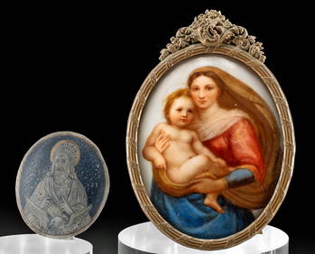
17th C. Niello Plaque + 19th C. Porcelain PaintingArtemis Fine Arts4.8(1.4k)See Sold PriceFeb 26, 2024
ANTIQUE 1686 OPERA OMNIA BY JOHN LIGHTFOOT TELLIMA BOUND FOLIO WITH ISRAEL MAPNY Elizabeth 4.3(84)See Sold PriceMar 03, 2024
CURTIUS RUFUS QUINTUS, SIXTEENTH-CENTURY ELZEVIER HISTORIARUM LIBRI W/ MAP 16.33NY Elizabeth 4.3(84)See Sold PriceMar 03, 2024