Sold17TH C. MAP, ASIAE NOVA DESCRIPTIOc. 1600, Abraham Ortelius 14.5 by 19 in. (image), matted, framed under glass Prov.: Daphne Farago collectionSee Sold Price
SoldOrtelius map, Asiae Nova Descriptio, c.1598[Asia]. Abraham Ortelius. Asiae Nova Descriptio. Double-page engraved map from Ortelius' ''Theatrum Orbis Terrarum,'' c.1598. 14 5/8 x 19 in. Dutch text on one side of verso with folio 2 lower margin.See Sold Price
Sold17th c Map of China- F. De WitChina.- De Wit (Frederick) Magn‘ Tartari‘, Magni Mogolis Imperii Japon‘ et Chin‘, nova descriptio, China and Tartary with Japan, ornamental cartouche, engraved map with hand-coSee Sold Price
ANTIQUE 17TH C MAP CASTILIA W. BLAEUAntique map of Castilia by W. Blaeu. Title: Utriusquae Castiliae Nova Descriptio. By: Willem Jansz. (also written Guilielmus Janssonius) -- Willem Janszoon Blaeu. Date of the first edition/map first pSee Sold Price
SoldHondius/Mercator map, Asiae, 1606-1623[Asia]. Jodocus Hondius, after Mercator. Asiae Nova Descriptio Auctore Jodoco Hondio. Double-page engraved map, c.1606 or later. 14 3/4 x 19 5/8 in. Early hand coloring, French heading on each side ofSee Sold Price
SoldOrtelius Engraved Map of AsiaAsiae Nova Descriptio. Abraham Ortelius (1527-1598). Engraved Map with hand color in full. Antwerp c. 1575. 16 1/2 x 20 1/2 inches sheet, 28 x 32 1/4 inches framedSee Sold Price
SoldCarribean/Arctic: 11 maps. Late 16th - late 19th[Miscellany]. 11 engraved maps, mostly in less than good condition, c.1600 to late 1800s. Includes: ++ Ortelius. Asiae Nova Descriptio. Uncolored, some loss. ++ Partie De La Mer Glaciale...Nova ZemblaSee Sold Price
SoldFünf Karten zu fränkischen Gebieten — 17. und 18.Five maps of Franconian areas — 17th and 18th C. ''Totius Franconiae Nova Descriptio'', cartographer Gerhard Mercator; copper engraving published by Joan Janssonius, Amsterdam around 1638; EnglSee Sold Price
SoldPaderborn, 5 historical mPaderborn, 5 historical maps of the 17th century, ''Paderbornensis Episcopatus descriptio nova'', diocese of Paderborn with two cartouches and miles, at Blaeu c. 1630. 3 x copperplate map ''DioecesisSee Sold Price
SoldOrtelius Antique Map: Asiae Nova DescriptioTitle/Content of Map: Asiae Nova Descriptio Date Printed: 1588 Cartographer: Abraham Ortelius Material/Medium: No color, strong impression. Spanish text on verso. From the first modern atlas- the TheaSee Sold Price
Soldmap, Asiae Nova Descriptio, MercatorUnframed handcolored engraved map, ''Asiae Nova Descriptio,'' by Gerhard Mercator (Flemish, 1512-1594), later copy of the 1595 map, plate: 14.56''h x 18.94''w, overall: 18.375''h x 23.125''w. Note: PaSee Sold Price
SoldA RENAISSANCE MAP, "Asiæ Nova Descriptio," ABRAHAMA RENAISSANCE MAP, "Asiæ Nova Descriptio," ABRAHAM ORTELIUS, ANTWERP, 1570-1612, hand colored engraving on paper, a fragment from an edition of Theatrum Orbis Terrarum, considered the "first modeSee Sold Price
SoldEngraved map Jodicus Hondius AsiaeFramed handcolored double-page engraved map, Asiae Nova Descriptio, by Jodicus Hondius the Elder (1563-1611), inscribed ''344'' and ''343'' verso upper left and right respectively, inscribed ''NouvellSee Sold Price
Asiae Nova Descriptio Auctore Jodoco HondioTitle/Content of Map: Asiae Nova Descriptio Auctore Jodoco Hondio Date Printed: 1613 Cartographer: Jodocus Hondius Material/Medium: paperSize: 53cm x 43cm Provenance: auction many years ago Reserve: $See Sold Price
Sold[MAPS] [ORTELIUS, ABRAHAM] Asiae Nova Descriptio.[MAPS] [ORTELIUS, ABRAHAM] Asiae Nova Descriptio. [Antwerp: 1570?]. * America Sive Orbis. Nova Descriptio. [Antwerp: 1570?]. Engraved maps colored by hand. Each 23 1/4 x 28 1/4 inches. Uniformly frameSee Sold Price
1606 Hondius Map of AsiaTitle: 1606 c. Hondius Map of Asia -- Asiae Nova Descriptio Cartographer: J Hondius Origin/Date: 1606 c., Amsterdam Size: 14.8 inches X 19.7 inches This is an excellent map of Asia. It is believed toSee Sold Price
SoldHondius Map of Asia, 1606Map: 1606 c. Hondius Map of Asia -- Asiae Nova Descriptio Cartographer: J Hondius Year / Place: 1606 c., Amsterdam Map Dimension: 14.8 X 19.7 in. This is an excellent map of Asia. It is believed to beSee Sold Price
SoldAsia.- Ortelius (Abraham) Asiae Nova Descriptio,Asia.- Ortelius (Abraham) Asiae Nova Descriptio, map of Asia showing from the Arabian Gulf, across India, South East Asia, China, and Japan, with part of Australia in the lower right quadrant, decoratSee Sold Price
Sold17th c. Map of Canaan by Juan Baptista Villalpando17th c. Map of Jerusalem Entitled DESCRIPTIO PARADISI, TERREA CANAAN, REGIONUMQUE A PATRIARCHIS, PRIMUM HABITATARUM [Description of Paradise, Earthly Canaan, Regions First Inhabited by of the PatriarcSee Sold Price
Asia.- Ortelius (Abraham) Asiae Nova Descriptio,Asia.- Ortelius (Abraham) Asiae Nova Descriptio, map of Asia showing from the Arabian Gulf, across India, South East Asia, China, and Japan, with part of Australia in the lower right quadrant, decoratSee Sold Price
SoldAsia.- Ortelius (Abraham) Asiae Nova Descriptio,Asia.- Ortelius (Abraham) Asiae Nova Descriptio, map of Asia showing from the Arabian Gulf, across India, South East Asia, China, and Japan, with part of Australia in the lower right quadrant, decoratSee Sold Price
SoldMap: nova descriptio Africae, c. 1638Map: nova descriptio Africae, c. 1638, Merian the Elder [Mathaus Merian] (Swiss, 1593-1650), hand-colored engraving on paper, 12.75"h x 14.75"w (sheet), 17"h x 19"w (frame)See Sold Price
Ortelius Map of Asia*** START PRICE IS THE RESERVE *** [Asia] ORTELIUS, Abraham (1527-1598). Asiae Nova Descriptio. Engraved map with original hand color in full. Antwerp, 1570 or later. 21 ¼Ã‚” x 17 &frac1See Sold Price
SoldOrtelius Map of AsiaORTELIUS, Abraham (1527-1598). Asiae Nova Descriptio. Engraved map with original hand color in full. Antwerp, after 1575 (Spanish edition). 18 3/4" x 22 3/4" sheet, 30" x 34" framed. Rare Spanish EditSee Sold Price
17TH C. ENGLISH CIVIL WAR HISTORY PAINTINGThomaston Place Auction Galleries4.4(386)See Sold PriceFeb 24, 2024
LARGE LATE 17TH C. DUTCH CHART OF CANADA, GREAT LAKES, NEW FRANCE, LABRADOR, HUDSON BAY, BY PIERREThomaston Place Auction Galleries4.4(386)See Sold PriceFeb 24, 2024
17TH C. WORLD MAP BY NICOLAES VISSCHER (NETHERLANDS, 1618-1709)Thomaston Place Auction Galleries4.4(386)See Sold PriceFeb 24, 2024
LATE 17TH C. FRENCH MAP OF THE NEW WORLD BY ALEXIS-HUBERT JAILLOT (1632-1712)Thomaston Place Auction Galleries4.4(386)See Sold PriceFeb 24, 2024
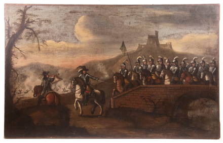
17TH C. ANTIQUE MAP SIEGE OF LA ROCHELLE, FRANCE, FRAMEDThomaston Place Auction Galleries4.4(386)See Sold PriceFeb 24, 2024
17TH C. MAP OF THE BERKSHIRES BY JOHN SPEED, FRAMEDThomaston Place Auction Galleries4.4(386)See Sold PriceFeb 24, 2024
17TH C. ENGLISH LINEAR MAP BY OGILBY, FRAMEDThomaston Place Auction Galleries4.4(386)See Sold PriceFeb 24, 2024
Antique 17th C English Geometric Oak Chest of DrawersKavanagh Auctions4.7(292)See Sold PriceFeb 24, 2024
17th Century Hand Colored Engraved Map of GermanyGlobal Auctions Company4.3(36)See Sold PriceMar 03, 2024
Willem Blaeu, Etc. 17th C. Antiquarian Maps, 2Auctions at Showplace4.5(726)See Sold PriceMar 17, 2024
De Jode, Rare, pub. 1593 - Map of Italy (Italiae Totius Orbis olim Domatricis Nova ExactissTrillium Antique Prints & Rare Books4.5(30)See Sold PriceFeb 24, 2024
Map: A 17thC engraved and hand coloured map after Frederik de Wit (1630-1706) titled Nova Persiae,Claydon Auctioneers Ltd4.3(125)See Sold PriceFeb 26, 2024
3 Vintage The World Lithographs, By JanssonThe Benefit Shop Foundation Inc.4.3(2.9k)See Sold PriceMar 13, 2024
1675: ANTIQUE ILLUSTRATED JULIUS CAESAR MAPS OF ROMAN HISTORYNY Elizabeth 4.3(84)See Sold PriceMar 03, 2024
Galliae Regionis Nova Descriptio Hand Colored Map of France on Laid Paper, Ca. 16th Century, H 10" WDuMouchelles4.6(825)See Sold PriceMar 15, 2024


![[MAPS] [ORTELIUS, ABRAHAM] Asiae Nova Descriptio. (1 of 1)](https://p1.liveauctioneers.com/292/8142/1390884_1_x.jpg?height=282&quality=70&version=1130939458)