Sold17th C. Christopher Saxton and William Hole MapDecorative strapwork title cartouche "Eboracensis Comitatus pars Septentrionalis vulgo North Riding"; includes compass rose and sailing ships; hand colored; London, c. 1637; framed and under glass inSee Sold Price
17th C. Christopher Saxton and William Hole MapDecorative strapwork title cartouche "Eboracensis Comitatus pars Septentrionalis vulgo North Riding"; includes compass rose and sailing ships; hand colored; London, c. 1637; framed and under glass inSee Sold Price
17th C. Hole after Saxton 1610 Map Eboracensis17th C. Hand colored copper engraving by William Hole after Christopher Saxton, Eboracensis North Riding Map, reduced map after 1585 original. Eboracensis Comitatus pars Septentrionalis Vulgo North RiSee Sold Price
17th C. Hole after Saxton 1610 Map Eboracensis17th C. Hand colored copper engraving by William Hole after Christopher Saxton, Eboracensis North Riding Map, reduced map after 1585 original. Eboracensis Comitatus pars Septentrionalis Vulgo North RiSee Sold Price
Sold17th C Kip after Saxton, Map of Wiltoniae17th C. William Kip after Christopher Saxton, Map of Wiltoniae Wiltoniae Comitatus herbida Planiciae nobiis vulgo willshire pars olim Belgarum [Wiltshire] Hand colored copper engraving. Reduced versioSee Sold Price
17th C. Kip after Saxton, Map of Bedford17th C. William Kip after Christopher Saxton, Map of Bedford 'BEDFORD Comitatus' olim pars Cathifuclnorum (Bedfordshire) Hand colored copper engraving, reduced version of original by Saxton from the 1See Sold Price
17th C Kip after Saxton, Map of Dunelmensis17th C William Kip after Christopher Saxton, Map of Dunelmensis, Durham. Dunelmensis Episcopatus (qui comi tatus est Palatinus) olim Brigantum [Durham] Hand colored copper engraving. Reduced version oSee Sold Price
17th C. Kip after Saxton, Map of Cambridge17th C. William Kip after Christopher Saxton, Map of Cambridge, CAMBRIDGE COMITATUS QUEM OLIM ICENI INSEDERUNT Hand colored copper engraving, marked plate 21 in lower left. Reduced version of 1585 oriSee Sold Price
Sold17th C Kip after Saxton, Map of Cumbria17th C William Kip after Christopher Saxton, Map of Cumbria 'CUMBRIA SIVE CUMBERLANDIA QUAE OLIM PARS BRIGANTUM' Hand colored copper engraving. Reduced version of original 1585. Approximately 13 x 11.See Sold Price
17th C Kip after Saxton, Map of Lincolniae17th C William Kip after Christopher Saxton, Map of Lincolniae 'LINCOLNIAE COMITATUS UBI OLIM INSEDERUNT CORITANI' (LINCOLNSHIRE) Hand colored copper engraving of reduced map after Saxtons original 15See Sold Price
17th C Kip after Saxton, Map of Wiltoniae17th C. William Kip after Christopher Saxton, Map of Wiltoniae Wiltoniae Comitatus herbida Planiciae nobiis vulgo willshire pars olim Belgarum [Wiltshire] Hand colored copper engraving. Reduced versioSee Sold Price
17th C Kip after Saxton, Map of Lincolniae17th C William Kip after Christopher Saxton, Map of Lincolniae 'LINCOLNIAE COMITATUS UBI OLIM INSEDERUNT CORITANI' (LINCOLNSHIRE) Hand colored copper engraving of reduced map after Saxtons original 15See Sold Price
17th C Kip after Saxton, Map of Cumbria17th C William Kip after Christopher Saxton, Map of Cumbria 'CUMBRIA SIVE CUMBERLANDIA QUAE OLIM PARS BRIGANTUM' Hand colored copper engraving. Reduced version of original 1585. Approximately 13 x 11.See Sold Price
17th C. Kip after Saxton, Map of Cambridge17th C. William Kip after Christopher Saxton, Map of Cambridge, CAMBRIDGE COMITATUS QUEM OLIM ICENI INSEDERUNT Hand colored copper engraving, marked plate 21 in lower left. Reduced version of 1585 oriSee Sold Price
17th C Kip after Saxton, Map of Dunelmensis17th C William Kip after Christopher Saxton, Map of Dunelmensis, Durham. Dunelmensis Episcopatus (qui comi tatus est Palatinus) olim Brigantum [Durham] Hand colored copper engraving. Reduced version oSee Sold Price
17th C. Kip after Saxton, Map of Bedford17th C. William Kip after Christopher Saxton, Map of Bedford 'BEDFORD Comitatus' olim pars Cathifuclnorum (Bedfordshire) Hand colored copper engraving, reduced version of original by Saxton from the 1See Sold Price
Sold18th century map, Saxton, YorkshireFramed handcolored engraved map, Eboracensis Comitatus pars Orientalis, vulgo East Riding [Yorkshire], by William Hole after Christopher Saxton (British 17th century), published London, 1637, sheet: 7See Sold Price
Sold18th century map, Saxton, YorkshireFramed handcolored engraved map, Eboracensis Comitatus pars Orientalis, vulgo East Riding [Yorkshire], by William Hole after Christopher Saxton (British 17th century), published London, 1637, sheet: 7See Sold Price
SoldSaxton (C) and W. Hole. LancastriæSaxton (Christopher) and William Hole. Lancastriæ comitatus palatinus olim pars Brigantum,Lancashire with decorative title cartouche and large compass rose, engraved map with hand-colouring, 2See Sold Price
SoldSaxton (C) & W. Hole. CaernarvonSaxton (Christopher) and William Hole. Caernavo Comitatus pars olim Ordovicum,Caernarvon, with strapwork title cartouche, compass rose, Neptune and mermaid embrace in the sea, engraved map witSee Sold Price
SoldSaxton (C) & W. Hole. Glocestriæ ComitatusSaxton (Christopher) and William Hole. Glocestriæ Comitatus olim sedes Dobunorum,Gloucestershire with large strapwork title cartouche, compass rose, engraved map with hand-colouring, 290 x 320See Sold Price
SoldSaxton (C) & W. Hole. Herefordiæ ComitatusSaxton (Christopher) and William Hole. Frugiferi ac Amæni Herefordiæ Comitatus,Herefordshire, ornamental title cartouche, royal coat-of-arms, engraved map with full hand-colouring, 285 x 310mmSee Sold Price
SoldWest Riding of Yorkshire, 17th century map engraved byWest Riding of Yorkshire, 17th century map engraved by William Hole, hand coloured, from the Christopher Saxton survey of 1577, 27cm x 33cmSee Sold Price
SoldSaxton and Hole. Comitatus BercheriaeSaxton and Hole. Comitatus Bercheriae Berkshire with ornamental title cartouche, engraved map with hand-colouring, 235 x 325mm., [c.1600] Saxton (Christopher) and William Kip. NorthamtoniaeSee Sold Price
PROTECTED BY THE WILLIAM J. BURNS DETECTIVE AGENCY PORCELAIN SIGN.Dan Morphy Auctions4.2(1.3k)See Sold PriceFeb 25, 2024
LARGE LATE 17TH C. DUTCH CHART OF CANADA, GREAT LAKES, NEW FRANCE, LABRADOR, HUDSON BAY, BY PIERREThomaston Place Auction Galleries4.4(393)See Sold PriceFeb 24, 2024
17TH C. WORLD MAP BY NICOLAES VISSCHER (NETHERLANDS, 1618-1709)Thomaston Place Auction Galleries4.4(393)See Sold PriceFeb 24, 2024
LATE 17TH C. FRENCH MAP OF THE NEW WORLD BY ALEXIS-HUBERT JAILLOT (1632-1712)Thomaston Place Auction Galleries4.4(393)See Sold PriceFeb 24, 2024
17TH C. ANTIQUE MAP SIEGE OF LA ROCHELLE, FRANCE, FRAMEDThomaston Place Auction Galleries4.4(393)See Sold PriceFeb 24, 2024
17TH C. MAP OF THE BERKSHIRES BY JOHN SPEED, FRAMEDThomaston Place Auction Galleries4.4(393)See Sold PriceFeb 24, 2024
17TH C. ENGLISH LINEAR MAP BY OGILBY, FRAMEDThomaston Place Auction Galleries4.4(393)See Sold PriceFeb 24, 2024
Willem Blaeu, Etc. 17th C. Antiquarian Maps, 2Auctions at Showplace4.6(740)See Sold PriceMar 17, 2024
Catherwood - General View of Uxmal, Taken from the Archway of Las Monjas, Looking SouthTrillium Antique Prints & Rare Books4.5(32)See Sold PriceFeb 24, 2024
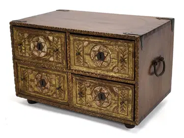
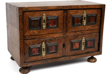
ANTIQUE INDO PORTUGUESE CARVED & GILT TABLE CHEST.William Smith Auctions4.6(147)See Sold PriceMar 06, 2024
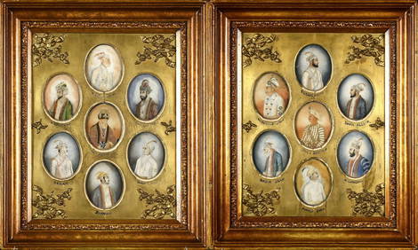
ANTIQUE INDO PORTUGUESE INLAID WALNUT TABLE TOP CHEST.William Smith Auctions4.6(147)See Sold PriceMar 06, 2024
14 ANTIQUE MINIATURE HAND PAINTED MUGHAL PORTRAITS.William Smith Auctions4.6(147)See Sold PriceMar 06, 2024
LATE 16TH/EARLY 17TH C. ITALIAN MAJOLICA CHARGER.William Smith Auctions4.6(147)See Sold PriceMar 06, 2024
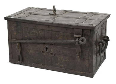
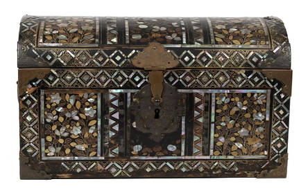
16TH C. JAPANESE MOMOYAMA INLAID LACQUERED CASKET.William Smith Auctions4.6(147)See Sold PriceMar 06, 2024