Sold17th C. British Maps, Ogilby and John Speed2 17th C. British Maps: Ogilby's "London to Portsmouth" and John Speed's Scotland. (2 pcs.) {TC} (GALL6004/2) Measurements: The Ogilby 15 1/2 x 19 1/2, framed 18 x 21; the Speed 14 x 19, unframed PleaSee Sold Price
Sold17th C. Hand-Colored Map of DorsetshyreA circa 1662 hand-colored British map of "Dorsetshyre" by John Speed (1551-1629) and engraved by Jodocus Hondius. Has an inset map of Dorchester upper left. Framed under glass. Mat opening: 15-1/2in xSee Sold Price
Sold17th C. John Speed, Huntington & Ely MapJohn Speed (British, 1552-1629), "Huntington, both Shire and Shire Town with the ancient citie Ely Described," hand colored, double engraved-page map originally created by noted cartographer, John SpeSee Sold Price
SoldJohn Speed 17th C Map Europe And The Chief CitiesJohn Speed (English, c.1551–1629). A hand colored 17th century map of Europe titled EUROP, AND THE CHIEFE CITIES, featuring description on verso. Measures 16 in. x 21 in. (sight), 20 1/2 in. x 25 1/See Sold Price
Sold17thC. JOHN SPEED MAP, OXFORDSHIRE, ENGRAVINGTitle: Map:Oxfordshire Described with ye Citie and the Armes of the Colledges of ye Famous University, Pub: John Speed, Date: Circa 1650, Medium: HC Engraving, Paper size: 15 1/2 x 21 1/4, Inscribed:See Sold Price
SoldJOHN OGILBY 17THC. MAP OF "THE ROAD FROM LONDON- TOTO YARMOUTH" (13 3/4" X 18" PLATE SIZE)See Sold Price
Sold17THC MAP/NORTHAMPTONSHIRE,HANDCOLORED,JOHN SPEED17THC MAP OF NORTHAMPTONSHIRE, HAND COLORED, JOHN SPEED, 21" X 25 1/2", SOME LOSSES AT EDGES, VERTICAL CREASE DOWN CENTER, UNFRAMED.See Sold Price
SoldJohn Speed Hand-Colored Map 17thC DevonshireJohn Speed hand-colored map, 1611-1646, "Devonshire with Excester Described and the armes of such nobles as have borne the titles of them", 16" x 21". Good condition.See Sold Price
SoldSix Antique English Maps and PlansSix Antique English Maps and Plans , incl. four John Ogilby road maps, 17th c. (13 3/4 in. x 17 in.); and two plates of London showing Christopher Wren and John Evelyn's designs for the rebuilding ofSee Sold Price
SoldJohn Speed 17th C Colored Map, Somerset ShireJohn Speed 17th C Colored Engraved Map, Somerset Shire, Englandwith coats of arms.Sudbury & Humble EditionDated: 1610, lower right.Dimensions: 20 1/4" x 15 1/4"Condition: Printed on hand made paper. VSee Sold Price
SoldJohn Speed (1552-1629) British after John NordenJohn Speed (1552-1629) British after John Norden (c.1546/48-c.1626) British. "Sussex", Map, 15.25" x 20.25".See Sold Price
Sold1610 John Speede Engraved Antique Map Of Surrey17th C John Speede Map Of Surrey. Surrey Described And Divided Into Hundreds' By John Speed Dated 1610. Includes View Of Richmont And Nonsuch Castles. London And The Thames Are Visible In The Upper PaSee Sold Price
SoldEARLY MAPS OF ENGLAND, IRELAND, & SCOTLANDEARLY MAPS OF ENGLAND, IRELAND, & SCOTLAND 17TH-18TH C. Comprising thirteen maps of various countries, including a 1675 John Ogilby map, entitled "The Road from London to Kingslyn," image size 17 incSee Sold Price
SoldJohn Speed (British, 1552-1629) Engraved Map ofJohn Speed (British, 1552-1629) Engraved Map of Scotland with Colors British, 17th century. An engraved map of Scotland with hand-coloring, full title: The Kingdome of Scotlantd in cartouche at upperSee Sold Price
SoldJohn Speed (British, 1552-1629) Engraved Map of SussexJohn Speed (British, 1552-1629) Engraved Map of Sussex with Colors British, 17th century. An engraved and hand-colored map of Sussex, full title: Sussex Described and divided into Rapes with the situaSee Sold Price
SoldJohn Ogilby etchingJohn Ogilby (Scottish 1600-1676)- ''The Road from Bristoll to Worcester'' road map- etching in color, 17th c., handling creases, soiling and scattered foxing. 12 1/8 x 17 1/4''See Sold Price
Sold2 Antique Maps, c. 1600, Florence & YorkshireTwo Antique Handcolored Maps, c. 1600, Florence by Don Stephano, late 16th c. & Yorkshire by John Speed, early 17th c. {ACGQ7041/2} (TC ) Dimensions: Florence 13.5 x 18.5, framed 20x25; the YorkshireSee Sold Price
SoldEngraved maps John Speed Johann Homann(Lot of 4) Unframed 17th-18th century engraved maps: ''Wales'' by John Speed (British 1542-1629), published in London, sold by Richard Chiswell and Thomas Basset, sheet: 16''H x 20 5/8''W. Condition:See Sold Price
(2) 17TH C. JOHN OGILBY ENGRAVINGSJohn Ogilby (1600-1676), English geographer and publisher Fluvius Grandis, Portuguese fort in the Amazon Delta, colonizers and slaves; the other,See Sold Price
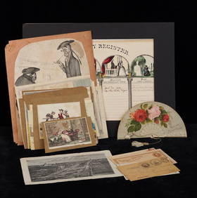
Sold[Ogilby (John)] Road from London to Barwick[Ogilby (John)] Road from London to Barwickengraved strip road map from Newcastle to Berwick, decorative cartouche, with hand-colouring, 325 x 445mm., [c.1670], and a map of the British IslesSee Sold Price
SoldJOHN OGILBY (BRITISH 1600-1676), COLORED ENGRAVINGJOHN OGILBY (BRITISH 1600-1676), COLORED ENGRAVING, MAP ROAD FROM DARTMOUTH TO MINHEAD, C.1697. SIGHT 13 1/2 X 18"; FRAMED AND GLAZED-21 X 25 1/2"See Sold Price
JOHN OGILBY (BRITISH 1600-1676), COLORED ENGRAVINGJOHN OGILBY (BRITISH 1600-1676), COLORED ENGRAVING, MAP ROAD FROM DARTMOUTH TO MINHEAD, C.1697. SIGHT 13 1/2 X 18"; FRAMED AND GLAZED-21 X 25 1/2"See Sold Price
SoldSpeed (John) England, Wales, Scotland and IrelandSpeed (John) England, Wales, Scotland and Ireland Described,pictorial title and 63 maps, including 2 folding of the British Isles and Yorkshire, engraved maps, each c.90 x 125mm., but the foldSee Sold Price
SoldThree 17th century reduced size county maps,Three 17th century reduced size county maps, Sussex by Van der Keere; Hertfordshire by Speed both hand coloured; and - Norfolk, (uncoloured) each 9 x 12.5cm; with John Ogilby The Road from London to SSee Sold Price
HONEST JOHN OLIVER by James Morton 1st Edition Inscribed by Author ScarceLuis Porretta Fine Arts4.3(10)See Sold PriceMar 02, 2024
LARGE LATE 17TH C. DUTCH CHART OF CANADA, GREAT LAKES, NEW FRANCE, LABRADOR, HUDSON BAY, BY PIERREThomaston Place Auction Galleries4.4(393)See Sold PriceFeb 24, 2024
17TH C. WORLD MAP BY NICOLAES VISSCHER (NETHERLANDS, 1618-1709)Thomaston Place Auction Galleries4.4(393)See Sold PriceFeb 24, 2024
LATE 17TH C. FRENCH MAP OF THE NEW WORLD BY ALEXIS-HUBERT JAILLOT (1632-1712)Thomaston Place Auction Galleries4.4(393)See Sold PriceFeb 24, 2024
17TH C. ANTIQUE MAP SIEGE OF LA ROCHELLE, FRANCE, FRAMEDThomaston Place Auction Galleries4.4(393)See Sold PriceFeb 24, 2024
17TH C. MAP OF THE BERKSHIRES BY JOHN SPEED, FRAMEDThomaston Place Auction Galleries4.4(393)See Sold PriceFeb 24, 2024
17TH C. ENGLISH LINEAR MAP BY OGILBY, FRAMEDThomaston Place Auction Galleries4.4(393)See Sold PriceFeb 24, 2024
GROUPING OF (19th c) BRITISH SATIRICAL PRINTS etcJohn McInnis Auctioneers,LLC4.5(505)See Sold PriceFeb 24, 2024
General Books - Nicolson - The Counties of Britain - A Tudor Atlas by John SpeedTimeLine Auctions Ltd.4.6(183)See Sold PriceMar 08, 2024
Willem Blaeu, Etc. 17th C. Antiquarian Maps, 2Auctions at Showplace4.6(740)See Sold PriceMar 17, 2024
Map: A 17thC engraved map of the British Isles titled A Generall Mapp of the Isles of GreatClaydon Auctioneers Ltd4.3(125)See Sold PriceFeb 26, 2024
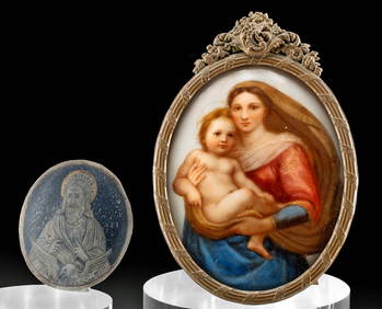
17th C. Niello Plaque + 19th C. Porcelain PaintingArtemis Fine Arts4.8(1.4k)See Sold PriceFeb 26, 2024
Antonio Rossetti 1800s Engraving "The Genius of Electricity" FRAMEDKCM Galleries4.7(164)See Sold PriceFeb 25, 2024


![[Ogilby (John)] Road from London to Barwick (1 of 1)](https://p1.liveauctioneers.com/410/8611/1592488_1_x.jpg?height=282&quality=70)