Sold1795 Joseph T. Scott's Map of Southwest Territoryfrom the United States Gazetteer. site size: H6 1/4" W7 3/8"See Sold Price
SoldScott's US Gazetteer S.W. & N.W. Territory MapsDESCRIPTION: Southwest and Northwest Territory maps from Joseph Scott's The United States Gazetteer circa 1795. Includes: 1) N.W. Territory including Louisiana, Otogamies, Chippewa, Mascoutens, & CanaSee Sold Price
Sold3 Early Southern and TN Maps, inc. Mero District plusFour (4) items total, 3 unframed maps and 1 book excerpt. 1st item: Joseph Scott: THE SOUTHWEST TERRITORY, Scott's Gazetteer, Phila. 1795, showing the Mero district, Nashville, Knoxville, ClarksvilleSee Sold Price
Sold1795 Joseph T. Scott's Map of Northwest Territoryfrom the United States Gazetteer. sight size: H6 1/4" W7 3/8"See Sold Price
SoldTWO 18TH C. VT MAPS, J. SCOTT & J. WHITELAW.James Whitelaw 1794 engraved map of VT in an antique frame 21” x 17” overall, Joseph Scott 1795 State of Vermont in an antique frame 17” x 15” overall.See Sold Price
Atlas of the United States 1795-1800Publication Date: c1960 Title: Atlas of the United States 1795-1800 Primary Authors: SCOTT, JOSEPH Publisher: BLOCH AND COMPANY 1795 - 1800. Featuring maps produced by Joseph Scott. 4to, unpaged. facsSee Sold Price
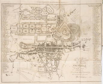
Sold[Maps & Atlases] Scott, Joseph, The United States[Maps & Atlases] Scott, Joseph The United States Gazetteer: Containing an Authentic description of the Several States... Philadelphia: F. and R. Bailey, 1795. First edition. 12mo. vi, (288) pp. IllustSee Sold Price
SoldFive Unframed 18th and 19th Century Mapsincluding Kentucky by Joseph T. Scott, 1795, 6-1/2 x 8-1/4 in.; County Map of Virginia and North Carolina by S. Augustus Mitchell, 1860, hand-colored, 12-1/2 x 15-1/4 in.; Battle-Field inSee Sold Price
SoldEarly Map of Tennessee, Daniel Smith, 1795A MAP OF THE TENNASSEE [sic] GOVERNMENT FORMERLY PART OF NORTH CAROLINA TAKEN CHIEFLY FROM SURVEYS BY GENL. D. SMITH & OTHERS, drawn by Daniel Smith, engraved by Joseph T. Scott, for "General Atlas FoSee Sold Price
SoldMap of the Tennessee Government, 1795 Smith"A Map of The Tennassee [sic] Government formerly Part of North Carolina taken Chiefly from Surveys By Genl. D. Smith & others" drawn by Daniel Smith, engraved by Joseph T. Scott, published by MatthewSee Sold Price
SoldTennessee Map Circa 1795"Map of the Tennassee government, formerly part of North Carolina, taken chiefly from surveys by Gen. D. Smith and others." Engraving by Joseph T. Scott for Careys American Edition of Guthrie's GeograSee Sold Price
Sold* SCOTT, Joseph. The United States Gazetteer.* SCOTT, Joseph. The United States Gazetteer. Philadelphia: F. and R. Bailey, 1795. 12mo (168 x 101 mm). Engraved title-page, 19 engraved folding maps. (Map of United States with a few short splits toSee Sold Price
SoldANTIQUARIAN PAPEREngraved map of Massachusetts designed by Samuel Lewis and engraved by Joseph T. Scott and published in Philadelphia, circa 1795, unframed and unmounted, 14 1/2'' x 18 1/2'', sheet size with margins 1See Sold Price
Sold1793 Joseph T. Scott's map of Kentuckyfrom the United States Gazetteer. sight size: H6 1/4" W7 3/8"See Sold Price
SoldJoseph Scott 1795 "The United States Gazeteer"book printed by F & R Bailey Philadelphia, 1795, leather bound.See Sold Price
SoldHOWELL, Reading (after) - Joseph T. SCOTT. A MapHOWELL, Reading (after) - Joseph T. SCOTT. A Map of the State of Pennsylvania from Mr. Howell's large Map. Philadelphia: [Matthew Carey?], c. 1794. Map engraved by Joseph T. Scott (310 x 510See Sold Price
Sold5V US Reference HISTORY OF MAPS OF NORTH AMERICA USA5V US Reference HISTORY OF MAPS OF NORTH AMERICA USA Cartography Books-On-Books 19th Century Alabama Dr John Mitchell Atlas Joseph Scott Southeast Early Maps Annotated Checklist Printed Manuscript LocSee Sold Price
1795 Pazzini Carli Map of Southwest England -- LeTitle: 1795 Pazzini Carli Map of Southwest England -- Le Provincie Che Sono al Sud Ouest Dell' Inghilterra Cartographer: Pazzini Carli [family] Year / Place: 1795, Siena Map Dimension (in.): 9.1 X 12.See Sold Price
1795 Pazzini Carli Map of Southwest England -- LeTitle: 1795 Pazzini Carli Map of Southwest England -- Le Provincie Che Sono al Sud Ouest Dell' Inghilterra Cartographer: Pazzini Carli [family] Year / Place: 1795, Siena Map Dimension (in.): 9.1 X 12.See Sold Price
1795 Pazzini Carli Map of Southwest England -- LeTitle/Content of Map: 1795 Pazzini Carli Map of Southwest England -- Le Provincie Che Sono al Sud Ouest Dell' Inghilterra Cartographer: Pazzini Carli [family] Year/Place: 1795, Siena Size: 9.1 X 12.1See Sold Price
1795 Pazzini Carli Map of Southwest England -- LeTitle: 1795 Pazzini Carli Map of Southwest England -- Le Provincie Che Sono al Sud Ouest Dell' Inghilterra Cartographer: Pazzini Carli [family] Year / Place: 1795, Siena Map Dimension (in.): 9.1 X 12.See Sold Price
SoldJOSEPH T. SCOTT (AMERICAN, 18TH/19TH C.) MAP OFJOSEPH T. SCOTT (AMERICAN, 18TH/19TH C.) MAP OF VIRGINIA, on laid paper, titled "VIRGINIA" in upper left corner, above scale; printed for "The New and Universal Gazetteer". Late 18th century. 7 1/2" xSee Sold Price
Sold"Kentucky" by Joseph T. Scott, 1795"Kentucky" by Joseph T. Scott, 1795. From United States Gazeteer, First state, 6 x 7¼ inches, Philadelphia. Very good; overall toning and off-setting; folds as issued. Wheat & Brun: 643See Sold Price
SoldMap of Switzerland. "Joseph T.Scott, Sculpt." appxMap of Switzerland. "Joseph T.Scott, Sculpt." appx. 2" tear along right side, not affecting map. browning and stained. ss: 8"h x 11"wSee Sold Price
Collection of Allied Military Silk Printed Maps, WWII Era and LaterMaterial Culture4.6(778)See Sold PriceFeb 29, 2024
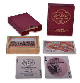
Fred Harvey Railroad Early Souvenir Playing Cards of the Great Southwest - Indians and Train SmokeRail & Road Auctions4.6(165)See Sold PriceMar 08, 2024
Fred Harvey Railroad Souvenir Playing Cards - Indians and Train Smoke and Indians of the SouthwestRail & Road Auctions4.6(165)See Sold PriceMar 08, 2024
[MAPS]. DUFOUR, Auguste-Henri (1795-1865). Bound Volume of ...Potter & Potter Auctions4.6(545)See Sold PriceMar 07, 2024
[MAP]. NICHOLLS, Sutton (1668-1729). An Epitome of Sr. Will...Potter & Potter Auctions4.6(545)See Sold PriceMar 07, 2024
Violin, late 18th century, Joseph Klotz, circa 1795, Mittenwald, GermanyTemplum Fine Art Auctions4.3(8)See Sold PriceFeb 28, 2024
Scotland.- Sir Walter Scott's Edinburgh.- The Post-Office annual directory, from Whitsunday 1808, toForum Auctions4.3(53)See Sold PriceFeb 29, 2024
Franz Johann Joseph von Reilly - The southern part of the Bishopric of Liège or the country ofProverde Auctions4.3(3)See Sold PriceFeb 28, 2024
The Kingdom of Dalmatia Territories Map, 1700Antiques Online Auctions4.6(415)See Sold PriceMar 14, 2024
Herman Moll A New Map of Ye North Parts of AmericaWillow Auction House4.5(289)See Sold PriceMar 14, 2024


![[Maps & Atlases] Scott, Joseph, The United States (1 of 3)](https://p1.liveauctioneers.com/65/192593/97105501_1_x.jpg?height=282&quality=70&version=1611610147)


![[MAPS]. DUFOUR, Auguste-Henri (1795-1865). Bound Volume of ... (1 of 2)](https://p1.liveauctioneers.com/928/318880/171361279_1_x.jpg?height=282&quality=70&version=1707501302)
![[MAP]. NICHOLLS, Sutton (1668-1729). An Epitome of Sr. Will... (1 of 1)](https://p1.liveauctioneers.com/928/318880/171361281_1_x.jpg?height=282&quality=70&version=1707501302)