Sold1776 map, Port Royal, South Carolina,"A Plan of Port Royal in South Carolina - Survey'd by Capn John Gascoigne", by John Gascoigne and Francis Swaine, published in [North American Pilot,] Sayer & Bennett, London, 1777, showing Port RoyalSee Sold Price
SoldMap of Port Royal Harbour Carolina by Herman Moll 1730Map: Plan of Port Royal Harbour in Carolina Maker: Herman Moll Date: 1730-32 Size: 8 x 10.5 inches Hilton Head and Port Royal, South Carolina. Moll notes on the map that it is "the best Country in CarSee Sold Price
SoldRevolutionary War mapof Port Royal, South Carolina, [Port Royal Dans la Caroline Meridionale, Leve par Le Cap: [sic] Gascoigne…" by George Louis Le Rouge, after map by Captain Gascoigne, showing Port Royal and surroundiSee Sold Price
SoldPort Royal Harbour, South Carolina 1877 MapFramed, this map measures about 20"Wx20"HSee Sold Price
Sold18th Century British Naval Map of Port Royal, SC18th Century British Naval Map of Port Royal, SCDes Barres, Joseph F. Wallet, PORT ROYAL IN SOUTH CAROLINA TAKEN FROM SURVEYS DEPOSITED AT THE PLANTATION OFFICE, disbound from THE ATLANTIC NEPTUNE (LoSee Sold Price
SoldGascoigne Faden A PLAN OF PORT ROYAL IN SOUTH CAROLINADetails: GASCOIGNE, John & William FADEN (1750-1836). A Plan of Port Royal in South Carolina. Survey'd by Capn. John Gascoigne. London: Jefferys & Faden, [1776]. Copper-engraved sea chart, in excelleSee Sold Price
SoldWilliam Faden and John Gascoigne, A Plan of the PortFADEN, William (1749-1836) – GASCOIGNE, John. A Plan of Port Royal in South Carolina. London: Jefferys & Faden, 1776. Engraved, uncolored. 32 ¾ x 25 ½ inches (unframed). Rare and highly detailed sSee Sold Price
SoldCoast of South Carolina (Great Naval Expedition), 1861Original wood engraving from Frank Leslie's Illustrated Newspaper, November 23, 1861. Map is of Port Royal and naval & military operations of the Great Naval Expedition of Commodor DuPont & General ShSee Sold Price
Map of Port Royal Harbor, SouthCarolina "A. Plan of Port Royal Harbor in Carolina with the proposed forts, depth of water & latitude...", after Herman Moll, Dutch, 1654-1732, 42 original drafts by Herman Moll, published in London bSee Sold Price
Beaufort River, Station Creek, Story and Harbor RiversTitle: Beaufort River, Station Creek, Story and Harbor Rivers Forming Inside Passage Between Port Royal and St. Helena Sounds, South Carolina... Publication Date: c1873 Cartographer: BOUTELLE, C.O./W.See Sold Price
Preliminary Chart of Port Royal Entrance Beaufort BroadTitle: Preliminary Chart of Port Royal Entrance Beaufort Broad and Chechessee Rivers South Carolina... Date: 1862 Cartographer: BOUTELLE, C.O./J.N. MAFFITT Publisher: U.S. COAST SURVEY Size: 32.8HeighSee Sold Price
Sold3 South Carolina MapsProperty from a Private Collection, Hilton Head Island, SC comprising a Preliminary Chart of Port Royal entrance dated 1863, matted and unframed (Size with mat: H. 35 1/4 in. x W. 28 1/4 in.), a map oSee Sold Price
SoldBombardment of Port Royal, South CarolinaView of the Bombardment of Port Royal, South Carolina Artist: C. Parsons Print Type: Engraving Date: 1862 Publisher: Virtue & YorstoSee Sold Price
SoldBombardment of Port Royal, South CarolinaView of the Bombardment of Port Royal, South Carolina Artist: C. Parsons Print Type: Engraving Date: 1862 Publisher: Virtue & YorstonSee Sold Price
SoldBombardment of Port Royal, South CarolinaView of the Bombardment of Port Royal, South Carolina Artist: C. Parsons Print Type: Engraving Date: 1862 Publisher: Virtue & YorstoSee Sold Price
Bombardment of Port Royal, South CarolinaView of the Bombardment of Port Royal, South Carolina Artist: C. Parsons Print Type: Engraving Date: 1862 Publisher: Virtue & Yorston OriSee Sold Price
SoldCivil War Etching of Port Royal South CarolinaCivil War Etching of Port Royal, South Carolina. This nice piece depicts the bombardment of Forts Walker & Beauregard Nov. 7th 1861. This etching is by George F. Perine. It has a visual measurement ofSee Sold Price
Bombardment of Port Royal, South CarolinaView of the Bombardment of Port Royal, South Carolina Artist: C. Parsons Print Type: Engraving Date: 1862 Publisher: Virtue & YorstoSee Sold Price
Bombardment of Port Royal, South CarolinaView of the Bombardment of Port Royal, South Carolina Artist: C. Parsons Print Type: Engraving Date: 1862 Publisher: Virtue & YorstoSee Sold Price
SoldRPC's Port Royal, South Carolina (6) (102766)RPC's of General View of Station; General View of Camp. No. 2 Marine Barracks; Hospital No. 3. "In the Trenches". Date: cearly 1900's City/County: State: South CarolinaSee Sold Price
Bombardment of Port Royal, South CarolinaView of the Bombardment of Port Royal, South Carolina Artist: C. Parsons Print Type: Engraving Date: 1862 Publisher: Virtue & YorstoSee Sold Price
Sold1884 PICKING COTTON FRANK LESLIEFrank Leslie Engraving, Picking, Ginning, Packing, & Shipping of Captured Confederate Cotton Crop. Sea Islands, Port Royal, South Carolina. Not a Reproduction. Original Wood Engraving from the 1884 EdSee Sold Price
SoldHand Colored Engraving of South Carolina Interest19th century. picking cotton, shipping cotton captured by the Federal Army on the Sea Islands at Port Royal, South Carolina. framed. H23 1/4" W29 1/2" Private Upcountry, South Carolina Collection.See Sold Price
Sold1884 PICKING COTTON FRANK LESLIEFrank Leslie Engraving, Picking, Ginning, Packing, & Shipping of Captured Confederate Cotton Crop. Sea Islands, Port Royal, South Carolina. Not a Reproduction. Original Wood Engraving from the 1884 EdSee Sold Price
Handmade Civil War Style South Carolina Ribbon CockadeConnoisseur Auctions4(333)See Sold PriceFeb 24, 2024
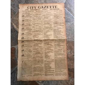
RARE 200 yr old Newspaper, City Gazette, Charleston SCConnoisseur Auctions4(333)See Sold PriceMar 02, 2024
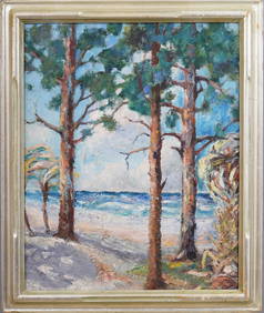
Nicely Framed Antique American Impressionist South Carolina Palm Tree Beach Seascape Oil PaintingCurated Gallery Auctions4.6(120)See Sold PriceFeb 25, 2024
Portfolio of 15 County Maps by Robert Morden (English 1650-1703)Nadeau's Auction Gallery4.7(401)See Sold PriceFeb 24, 2024
Carey, pub. 1796 - Map of The State of South CarolinaTrillium Antique Prints & Rare Books4.5(30)See Sold PriceFeb 24, 2024
Carey, pub. 1796 - Map of the Tennassee State formerly part of North Carolina (Tennessee)Trillium Antique Prints & Rare Books4.5(30)See Sold PriceFeb 24, 2024
West Indies. South Coast of Jamaica from Port Royal to Pedro Bluff.Jasper524.5(9.8k)See Sold PriceFeb 27, 2024
1764 Bellin Chart of Three South Haitian Bays -- Carte des Bayes du Mesle des Flamands et deJasper524.5(9.8k)See Sold PriceFeb 27, 2024
Jacques Nicolas Bellin - View of the entrance to Zihuatanejo Bay - View of the entrance to the portProverde Auctions4.3(3)See Sold PriceFeb 28, 2024


![[Tintype] Clear Portrait (1 of 1)](https://p1.liveauctioneers.com/7226/317626/170485463_1_x.jpg?height=282&quality=70&version=1706368022)