ATLAS of ANTIENT GEOGRAPHY by SAMUEL BUTLER 1843John McInnis Auctioneers,LLC4.5(505)See Sold PriceFeb 24, 2024
18TH C. ANTIQUE MAP: FRENCH & INDIAN WAR, FRAMEDThomaston Place Auction Galleries4.4(393)See Sold PriceFeb 24, 2024
Rand McNally Railroad Map Cabinet w/ 21 Railroad MapsRail & Road Auctions4.6(165)See Sold PriceMar 08, 2024
Keith Haring - Ink on New York Map, Best Buddies, Inscribed, Signed, and DatedSapphire Auction Gallery4(67)See Sold PriceMar 02, 2024
LATE 17TH C. FRENCH MAP OF THE NEW WORLD BY ALEXIS-HUBERT JAILLOT (1632-1712)Thomaston Place Auction Galleries4.4(393)See Sold PriceFeb 24, 2024
Central Railroad of New Jersey Map of Sandy Hook Route-ca. 1903JM Hobby Supply and Railroad Artifact Auctions4.4(127)See Sold PriceFeb 24, 2024
Lot of Six Mixed Atlas Box Cars-HO Scale-New in BoxJM Hobby Supply and Railroad Artifact Auctions4.4(127)See Sold PriceFeb 25, 2024
Rand McNally/Santa Fe Railroad Map of Iowa-1912JM Hobby Supply and Railroad Artifact Auctions4.4(127)See Sold PriceFeb 24, 2024
NICOLAES VISSCHER (NETHERLANDS, 1618-1709) MAP OF THE NEW WORLDThomaston Place Auction Galleries4.4(393)See Sold PriceFeb 24, 2024
17TH C. WORLD MAP BY NICOLAES VISSCHER (NETHERLANDS, 1618-1709)Thomaston Place Auction Galleries4.4(393)See Sold PriceFeb 24, 2024
Lot of Six Mixed Atlas Cabooses-HO Scale-New in BoxJM Hobby Supply and Railroad Artifact Auctions4.4(127)See Sold PriceFeb 25, 2024
1730 Wetstein Map Of Ancient Europe and Middle East --Title: 1730 Wetstein Map Of Ancient Europe and Middle East -- De Oude Wereldt Tot Beter Verstandt der Oude Geschiendenissen in Het Licht Gegeven en Nagezien Door Isaak Vernburg Cartographer: R & D WetSee Sold Price
Orbis Veteribus Notus. World as known to the Ancients.TITLE/CONTENT OF MAP: 'Orbis Veteribus Notus' The world as known to the Ancients. Europe, North Africa, the Middle East, South Asia and Indochina Date: Published in 1785. Engraved in 1785 (this date iSee Sold Price
Orbis Veteribus Notus. World as known to the Ancients.TITLE/CONTENT OF MAP: 'Orbis Veteribus Notus' The world as known to the Ancients. Europe, North Africa, the Middle East, South Asia and Indochina Date: Published in 1785. Engraved in 1785 (this date iSee Sold Price
Orbis Veteribus Notus. World as known to the Ancients.TITLE/CONTENT OF MAP: 'Orbis Veteribus Notus' The world as known to the Ancients. Europe, North Africa, the Middle East, South Asia and Indochina DATE PRINTED: Published in 1785. Engraved in 1785 (thiSee Sold Price
SoldHoly Land.- Middle East.- Ortelius (Abraham) GeographiaHoly Land.- Middle East.- Ortelius (Abraham) Geographia Sacra, map of the ancient Biblical world including southern Europe, northern Africa and the Middle East, with inset map of the world in the loweSee Sold Price
SoldMiddle East.- Ortelius (Abraham) Geographia Sacra, mapMiddle East.- Ortelius (Abraham) Geographia Sacra, map of the ancient Biblical world including southern Europe, northern Africa and the Middle East, with inset map of the world in the lower centre, aSee Sold Price
SoldAncient Middle East. Holy land. Jordan, Syria, Lebanon,Title/Content of Map: Ancient Middle East. Holy land. Jordan, Syria, Lebanon, Iraq Cyprus. Date: 1598/99 Cartographer: By Ruscelli Size: 11x9” Provenance: Venice Reserve: $200.00 Shipping: Domestic:See Sold Price
1730 Wetstein Map of Europe During Charlemaigne's RuleTitle/Content of Map: 1730 Wetstein Map of Europe During Charlemaigne's Rule -- Het Ryk van Carel den Groten Cartographer: R & D Wetstein Year/Place: 1730 c., Amsterdam Size: 14.1 X 20 in. This is a fSee Sold Price
1730 Wetstein Map of Europe During Charlemaigne's RuleTitle: 1730 Wetstein Map of Europe During Charlemaigne's Rule -- Het Ryk van Carel den Groten Cartographer: R & D Wetstein Year/Place: 1730 c., Amsterdam Dimensions: 14.1 X 20 in. Description: This isSee Sold Price
Soldgoup of maps of Europe & Middle EastWorld.- A mixed goup of maps of Europe and the Middle East, including France, Germany, Switzerland, Denmark and the Nederlands, Turkey, Syria, by or for J. Wylde, Thomas Kitchin, N. Vischer, NSee Sold Price
SoldAntique Map: Kingdom of PersiaRegnum Persicum Imperium Turcicum in Asia by Ottens (1730). Map of the Middle East with the Kingdom of the Persian, Empire in the Turkish province of Asia, Russia to the Caspian Sea. Copper engraving,See Sold Price
SoldJansson (Jan) - Europam, sive Celticum veterem,map of Europe, the Middle East and North Africa in the time of the Celts, after Abraham Ortelius, engraved map with hand-colouring, 350 x 470mm., central vertical fold, without text verso, some pale bSee Sold Price
Maps by Cellarius of the ancient Middle EastHeading: Author: Cellarius, Christoph Title: Four maps of the ancient Middle East Place Published: No place Publisher: Date Published: Early 1700's Description: Copper-engrSee Sold Price
SoldA small, mixed group of mapsBritish Isles.- A small, mixed group of maps, of Europe, the Middle East, India, Russia, Brazil and the world, engravings, from 180 x 110 to 200 x 510mm., various conditions, mostly 19th centuSee Sold Price
SoldLot Of 9 Vintage Maps ( World Maps, US Army 1939 )Map Of Artic ocean including Siberia and Alaska, Artic ocean including Greenland, Finland etc., A map of Europe,Asia,Africa, Middle east, A map of Argentina,Peru,Brazil substantially ripped, Pacific ASee Sold Price
SoldAn assortment of 9 printed maps on silk and cotton,An assortment of 9 printed maps on silk and cotton, including maps of Europe, some of the Middle East, including one of Constantinople, and a Nippon Times map of Japan printed on silk, various sizes,See Sold Price
Antique Map Print - Map of Mediterranean - Parts of Europe, Africa, Middle EastTitle: Antique Map Print - Map of Mediterranean - Parts of Europe, Africa, Middle East Date: 1725 Material: Paper Dimensions: 20” x 15” inches / 50 cm x 39 cm Descritpion: Fantastic antiquSee Sold Price
British & American Diplomatic Representation Europe Middle East Maghreb 1952 mapTITLE/CONTENT OF MAP: 'British and American Representation in Europe, The Middle East and North Africa' DATE PRINTED: 1952 IMAGE SIZE: Approx 49.5 x 72.0cm, 19.5 x 28.25 inches (Large) TYPE: Antique cSee Sold Price
SoldKorean War Era Escape & Evasion Map of E. Europe hhis is a Korean War era escape and evasion map of Eastern Europe, North Africa, and Middle East. Maps such as this are made from silk. They were carried by bomber flight crews. These maps were sewn inSee Sold Price
Sold1940's Bordens's World War 2 Map and Others1940's Borden's Ice Cream dated events war map, showing lithography of Europe, Africa, the Middle East and parts of South America; copyrights begin at 1942, has photographs of Genrals Eisenhower and MSee Sold Price
WONDERFUL HAND DRAWN WORLD MAP11 1/2" x 9" hand drawn pen and ink map of Western Europe, North Africa and the Middle East. Wonderfully detailed and beautifully accomplished, this is a hand-drawn map displaying superb artwork. ExtrSee Sold Price
SoldS.D.U.K. AtlasSociety For The Diffusion Of Useful Knowledge (The) Atlas,2 vol, 3 world maps and c.80 others of Britain, Europe, the Middle East, and Asia in vol I, and 48 continental, national and regionalSee Sold Price
SoldCarey & Lea: Map of Syria, Mesopotamia, Assyria, 1832Syria, Mesopotamia, Assyria, &c. Pub. 1832 by Carey & Lea. 7 x 9. Antique hand colored map of Syria, Mesopotamia, Assyria, and other surrounding areas in the Ancient Middle East (mainly comprising modSee Sold Price
ROUTES TO INDIA Europe Middle East & Asia. Suez CanalTITLE/CONTENT OF MAP: 'Routes to India; Inset maps of Gibraltar; Maltese Islands; Suez Canal' This map is folding hence the centrefold line may show on the image below DATE PRINTED: 1912 IMAGE SIZE: ASee Sold Price
Sumerian Terracotta 'Bulla Envelope' with Impressed DecorationTimeLine Auctions Ltd.4.6(183)See Sold PriceMar 05, 2024
Western Asiatic Turquoise Blue Glass Bead Necklace StringTimeLine Auctions Ltd.4.6(183)See Sold PriceMar 07, 2024
Western Asiatic Turquoise Blue Glass Bead Necklace StringTimeLine Auctions Ltd.4.6(183)See Sold PriceMar 07, 2024
Raphael Jacquemin. Hand colored historical fashion plates. Medieval and early modern periods fromTremont Auctions4.5(297)See Sold PriceFeb 25, 2024
Jean Etienne LIOTARD (1702-1789) Att. to - "Portrait of a woman" Oil on panel.GOLDFIELD AUCTION4.3(32)See Sold PriceMar 02, 2024
Antique Red Silk Robe, Possibly Roma People, Eastern Europe or Middle EastMaterial Culture4.6(778)See Sold PriceFeb 29, 2024
[MAPS]. DUFOUR, Auguste-Henri (1795-1865). Bound Volume of ...Potter & Potter Auctions4.6(545)See Sold PriceMar 07, 2024
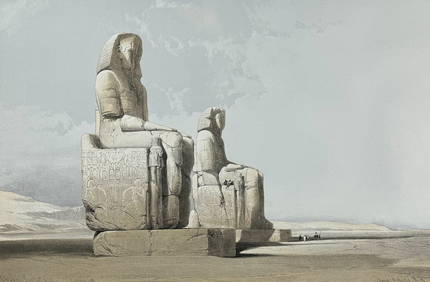
David Roberts - Obelisk of LuxorTrillium Antique Prints & Rare Books4.5(32)See Sold PriceFeb 24, 2024
David Roberts - Approach of the Simoom, Desert of GizehTrillium Antique Prints & Rare Books4.5(32)See Sold PriceFeb 24, 2024
De Jode, Rare, pub. 1593 - Map of the Middle East, Eastern Asia (Primae Partis Asiae accurataTrillium Antique Prints & Rare Books4.5(32)See Sold PriceFeb 24, 2024
Maison Jansen Pair of Bronze & Mirror Sconces H: 24" W: 16" FranceCarstens Galleries4.5(132)See Sold PriceMar 01, 2024
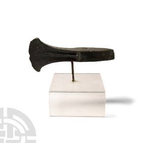
ANCIENT 800 BC HOLY LAND MIDDLE EAST TERRACOTTA PIECESAntique Arena Inc.4.5(878)See Sold PriceJun 15, 2024


![[MAPS]. DUFOUR, Auguste-Henri (1795-1865). Bound Volume of ... (1 of 2)](https://p1.liveauctioneers.com/928/318880/171361279_1_x.jpg?height=282&quality=70&version=1707501302)