1705 REGIONAL NORTH AMERICA HAND-COLORED MAP FEAT
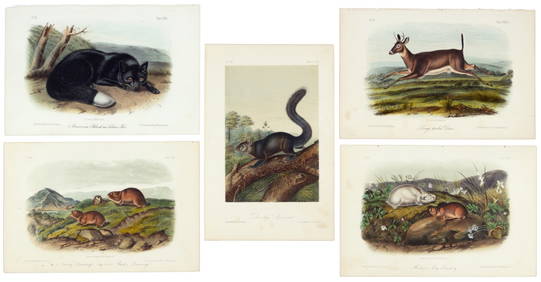
Map: An 18thC engraved and hand coloured map of North America and South America, titled DeFeb 26, 2024De l'Isle's influential map of Americas 1722Mar 07, 2024Americas with Californa an island 1705Mar 07, 2024Weigel map of Americas Calif. an islandMar 07, 2024First 50 plates from Audubon's Quad Quarto (all in Vol. I)Mar 07, 2024Audubon, 47 hand-colored lithos from Quad QuartoMar 07, 2024Nearly complete set of plates from Vol. III Quad QuartoMar 07, 2024Mercator's map of China 1606Mar 07, 2024Large map of the Americas 1794Mar 07, 2024Colored lithograph of Sac & Fox chief KeokukMar 07, 2024Colored lithograph of Chippeway chief 1836Mar 07, 2024Color litho of chief of Yankton SiouxMar 07, 2024War dance of Sauks & Foxes from McKenny & HallMar 07, 202415 Maps of North America 1st half of 19th centuryMar 07, 2024Janvier map of North AmericaMar 07, 2024Lapie map of N. America with independent TexasMar 07, 2024Italian edition of Sanson's map of North America, 1677Mar 07, 2024Sanson/Jaillot map of North America 1719Mar 07, 2024Tanner's North America independent TexasMar 07, 2024North America in 1814Mar 07, 2024Large wall map of U.S. & Central AmericaMar 07, 2024Wall map of North America 1856Mar 07, 2024H.J. Warre litho of Prairie Fire 1848Mar 07, 2024MAP, North Pole, BowenMar 12, 2024 


![[NORTH AMERICA/CANADA]. 6 hand-colored lithog (1 of 1)](https://p1.liveauctioneers.com/179/10971/2682757_1_x.jpg?height=282&quality=70&version=1162265652)