ATLAS of ANTIENT GEOGRAPHY by SAMUEL BUTLER 1843John McInnis Auctioneers,LLC4.5(505)See Sold PriceFeb 24, 2024
18TH C. ANTIQUE MAP: FRENCH & INDIAN WAR, FRAMEDThomaston Place Auction Galleries4.4(393)See Sold PriceFeb 24, 2024
Rand McNally Railroad Map Cabinet w/ 21 Railroad MapsRail & Road Auctions4.6(165)See Sold PriceMar 08, 2024
Keith Haring - Ink on New York Map, Best Buddies, Inscribed, Signed, and DatedSapphire Auction Gallery4(67)See Sold PriceMar 02, 2024
LATE 17TH C. FRENCH MAP OF THE NEW WORLD BY ALEXIS-HUBERT JAILLOT (1632-1712)Thomaston Place Auction Galleries4.4(393)See Sold PriceFeb 24, 2024
Central Railroad of New Jersey Map of Sandy Hook Route-ca. 1903JM Hobby Supply and Railroad Artifact Auctions4.4(127)See Sold PriceFeb 24, 2024
Lot of Six Mixed Atlas Box Cars-HO Scale-New in BoxJM Hobby Supply and Railroad Artifact Auctions4.4(127)See Sold PriceFeb 25, 2024
Rand McNally/Santa Fe Railroad Map of Iowa-1912JM Hobby Supply and Railroad Artifact Auctions4.4(127)See Sold PriceFeb 24, 2024
NICOLAES VISSCHER (NETHERLANDS, 1618-1709) MAP OF THE NEW WORLDThomaston Place Auction Galleries4.4(393)See Sold PriceFeb 24, 2024
17TH C. WORLD MAP BY NICOLAES VISSCHER (NETHERLANDS, 1618-1709)Thomaston Place Auction Galleries4.4(393)See Sold PriceFeb 24, 2024
Lot of Six Mixed Atlas Cabooses-HO Scale-New in BoxJM Hobby Supply and Railroad Artifact Auctions4.4(127)See Sold PriceFeb 25, 2024
Sold1700 c. Sanson Map of the Arabian Peninsula and the RedTitle/Content of Map: 1700 c. Sanson Map of the Arabian Peninsula and the Red Sea -- Arabia Petrea, Deserta et Felix Per N. Sanson Date: c. 1700 Cartographer: Based on N. Sanson Size: 7.5 X 9.5 in. ThSee Sold Price
Sold1652 Sanson Map of the Arabian Peninsula and the RedTitle: 1652 Sanson Map of the Arabian Peninsula and the Red Sea -- L'Arabie Petree, Deserte, et Heureuse Cartographer: N Sanson Year / Place: 1652, Paris Map Dimension (in.): 7.5 X 9.5 in. This is a rSee Sold Price
1652 Sanson Map of the Arabian Peninsula and the RedTitle/Content of Map: 1652 Sanson Map of the Arabian Peninsula and the Red Sea -- L'Arabie Petree, Deserte, et Heureuse Date: 1652, Paris Cartographer: N Sanson Size: 7.5 X 9.5 in. This is a rather beSee Sold Price
1652 Sanson Map of the Arabian Peninsula and the RedTitle/Content of Map: 1652 Sanson Map of the Arabian Peninsula and the Red Sea -- L'Arabie Petree, Deserte, et Heureuse Date: 1652, Paris Cartographer: N Sanson Size: 7.5 X 9.5 in. This is a rather beSee Sold Price
1652 Sanson Map of the Arabian Peninsula and the RedTitle: 1652 Sanson Map of the Arabian Peninsula and the Red Sea -- L'Arabie Petree, Deserte, et Heureuse Year/Place: 1652, Paris Cartographer: N Sanson Size: 7.5 X 9.5 in. Additional Information: ThisSee Sold Price
1652 Sanson Map of the Arabian Peninsula and the RedTitle/Content of Map: 1652 Sanson Map of the Arabian Peninsula and the Red Sea -- L'Arabie Petree, Deserte, et Heureuse Date: 1652, ParisCartographer: N Sanson Size: 7.5 X 9.5 in. This is a rather beaSee Sold Price
1652 Sanson Map of the Arabian Peninsula and the RedTitle/Content of Map: 1652 Sanson Map of the Arabian Peninsula and the Red Sea -- L'Arabie Petree, Deserte, et Heureuse Cartographer: N Sanson Year/Place: 1652, Paris Size: 7.5 X 9.5 in. This is a ratSee Sold Price
SoldArabian Peninsula.- Thomson (John) Arabia, Egypt,Arabian Peninsula.- Thomson (John) Arabia, Egypt, Abyssinia, Red Sea &c., map showing the Arabian Peninsula, the Horn of Africa, the Red Sea and the Persian Gulf, engraving with early outline hand-colSee Sold Price
Sold1770 Bonne Map of the Arabian Peninsula and Red Sea --Title/Content of Map: 1770 Bonne Map of the Arabian Peninsula and Red Sea -- Carte de l'Arabie du Golfe Persique, et de la Mer Rouge avec l'Egypte, la Nubie et l'Abissinie Date: 1170 c., Paris CartogrSee Sold Price
Sold1660 Jansson Map of the Arabian Peninsula and Red SeaTitle: 1660 Jansson Map of the Arabian Peninsula and Red Sea -- Arabiae Felicis, Petrae ae et Desertae Nova et Accurata Delineatio Cartographer: J Jansson Year / Place: 1660 c., Amsterdam Map DimensioSee Sold Price
1660 Jansson Map of the Arabian Peninsula and Red SeaTitle/Content of Map: 1660 Jansson Map of the Arabian Peninsula and Red Sea -- Arabiae Felicis, Petrae ae et Desertae Nova et Accurata Delineatio Date: 1660 c., Amsterdam Cartographer: J Jansson Size:See Sold Price
1660 Jansson Map of the Arabian Peninsula and Red SeaTitle/Content of Map: 1660 Jansson Map of the Arabian Peninsula and Red Sea -- Arabiae Felicis, Petrae ae et Desertae Nova et Accurata Delineatio Date: 1660 c., Amsterdam Cartographer: J Jansson Size:See Sold Price
1660 Jansson Map of the Arabian Peninsula and Red SeaTitle/Content of Map: 1660 Jansson Map of the Arabian Peninsula and Red Sea -- Arabiae Felicis, Petrae ae et Desertae Nova et Accurata Delineatio Cartographer: J Jansson Year/Place: 1660 c., AmsterdamSee Sold Price
1660 Jansson Map of the Arabian Peninsula and Red SeaTitle: 1660 Jansson Map of the Arabian Peninsula and Red Sea -- Arabiae Felicis, Petrae ae et Desertae Nova et Accurata Delineatio Date: 1660 c., Amsterdam Cartographer: J Jansson Size: 17.3 X 20.2 inSee Sold Price
1660 Jansson Map of the Arabian Peninsula and Red SeaTitle: 1660 Jansson Map of the Arabian Peninsula and Red Sea -- Arabiae Felicis, Petrae ae et Desertae Nova et Accurata Delineatio Cartographer: J Jansson Year/Place: 1660 c., Amsterdam Map DimensionsSee Sold Price
SoldNova Persiae Armeniae Natoliae et ArabiaeFrederick de Wit (c. 1630-1706). Engraved Map with hand color in full. Amsterdam: F. De Wit, [c. 1710]. (20 ¾ x 24 ¾ inches sheet. The detail in the Arabian peninsula is based on Sanson’s map of 1See Sold Price
1843 SDUK Map of Arabian Peninsula, Red Sea, Egypt --Title: 1843 SDUK Map of Arabian Peninsula, Red Sea, Egypt -- Arabia with Egypt, Nubia and Abyssinia Date: 1843, London Cartographer: SDUK Size: 13.1 X 15.9 in. Additional Information: This a highly deSee Sold Price
1843 SDUK Map of Arabian Peninsula, Red Sea, Egypt --Title/Content of Map: 1843 SDUK Map of Arabian Peninsula, Red Sea, Egypt -- Arabia with Egypt, Nubia and Abyssinia Date: 1843, London Cartographer: SDUK Size: 13.1 X 15.9 in. This a highly detailed maSee Sold Price
1843 SDUK Map of Arabian Peninsula, Red Sea, Egypt --Title/Content of Map: 1843 SDUK Map of Arabian Peninsula, Red Sea, Egypt -- Arabia with Egypt, Nubia and Abyssinia Date: 1843, London Cartographer: SDUK Size: 13.1 X 15.9 in. This a highly detailed maSee Sold Price
1843 SDUK Map of Arabian Peninsula, Red Sea, Egypt --Title/Content of Map: 1843 SDUK Map of Arabian Peninsula, Red Sea, Egypt -- Arabia with Egypt, Nubia and Abyssinia Cartographer: SDUK Year/Place: 1843, London Size: 13.1 X 15.9 in. This a highly detaiSee Sold Price
CHARLES KINGSLEY ILLUSTRATIONS BY H.C.SELOUS OF HEREWARD THE WAKE (ART UNION OF LONDON)Luis Porretta Fine Arts4.3(10)See Sold PriceMar 02, 2024
LARGE LATE 17TH C. DUTCH CHART OF CANADA, GREAT LAKES, NEW FRANCE, LABRADOR, HUDSON BAY, BY PIERREThomaston Place Auction Galleries4.4(393)See Sold PriceFeb 24, 2024
17TH C. WORLD MAP BY NICOLAES VISSCHER (NETHERLANDS, 1618-1709)Thomaston Place Auction Galleries4.4(393)See Sold PriceFeb 24, 2024
LATE 17TH C. FRENCH MAP OF THE NEW WORLD BY ALEXIS-HUBERT JAILLOT (1632-1712)Thomaston Place Auction Galleries4.4(393)See Sold PriceFeb 24, 2024
EARLY 18TH C. MAP OF ITALY, FRAMEDThomaston Place Auction Galleries4.4(393)See Sold PriceFeb 24, 2024
18TH C. ANTIQUE MAP: FRENCH & INDIAN WAR, FRAMEDThomaston Place Auction Galleries4.4(393)See Sold PriceFeb 24, 2024
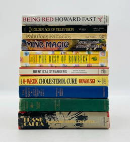
10 Books Including: Being Red, Mind Magic, Frank Capra, The Arabian Nights +Cain Modern Auctions4.4(45)See Sold PriceFeb 28, 2024
Johann Homann Hand-Colored Map Engraving, c. 1730Auctions at Showplace4.6(740)See Sold PriceMar 17, 2024
Willem Blaeu, Etc. 17th C. Antiquarian Maps, 2Auctions at Showplace4.6(740)See Sold PriceMar 17, 2024
Jules Verne, Le Testament d'un Excentrique, Aux HarponsLion and Unicorn4.8(1.9k)See Sold PriceMar 03, 2024
1683 Sanson Map of the Caribbean -- Les Isles Antilles, &c Entre Lesquelles sont les Lucayes, et lesJasper524.5(9.9k)See Sold PriceFeb 27, 2024
Tour of the Dutch East Indies, with exceptional platesPBA Galleries4.7(385)See Sold PriceMar 07, 2024
Jules Verne, L'Etoile du Sud, Au Steamer Red MacaronLion and Unicorn4.8(1.9k)See Sold PriceMar 10, 2024