16TH C. MAPS 3: ASIA, 14" X 19", EUROPE,"16TH C. MAPS 3: ASIA, 14"" X 19"", EUROPE, 13"" X 18"" & AFRICA, 15"" X 19"", THREE:All hand colored, marked in pencil in lower right margin, ""Ortelius Anvers 1579"", appear to be unsigned and are uSee Sold Price
SoldHondius [Family]. Nova Europae Descriptio. c.1630.[Europe] Hondius, Jodocus and Family. “Nova Europae Descriptio Auctore Iodoco Hondio.” Amsterdam, c. 1630. Engraved map. 19 3/4” x 14 3/4”. Framed: 30 5/8” x 26 1/8&rdquoSee Sold Price
SoldHondius/Mercator map, Asiae, 1606-1623[Asia]. Jodocus Hondius, after Mercator. Asiae Nova Descriptio Auctore Jodoco Hondio. Double-page engraved map, c.1606 or later. 14 3/4 x 19 5/8 in. Early hand coloring, French heading on each side ofSee Sold Price
Sold16THC. MAP OF MEXICO (HISPANIAE NOVAE SIVAE) BY A.BY A. ORTELIUS (13 3/4" X 19 3/4" PLATE SIZE)See Sold Price
AMERICAN MAPS, 3, 17-19TH C. VIRGINIA/FLORIDA"AMERICAN MAPS, 3, 17-19TH C., VIRGINIA/FLORIDA, 13"" X 19"", 2 MAPS OF AMERICA, 16"" X 21"" & 14"" X 19"":Virginia & Florida is hand colored, 13 1/4"" x 19 1/8"", text on verso, appears to be unsigneSee Sold Price
SoldHondius Map of Asia, 1606Map: 1606 c. Hondius Map of Asia -- Asiae Nova Descriptio Cartographer: J Hondius Year / Place: 1606 c., Amsterdam Map Dimension: 14.8 X 19.7 in. This is an excellent map of Asia. It is believed to beSee Sold Price
Sold16th C. Dutch School, Portrait of Man, O/B16th century Dutch School, portrait of a man, oil on board, 19" h x 14 3/4" w (view), 23 1/2" h x 19 1/2" w (frame). Provenance: From a New York collection.See Sold Price
Sold16thC "Abraham Ortelius" Map of Ancient Belgium and16thC "Abraham Ortelius" Map of Ancient Belgium and English Coast, Engraved two part map with hand color, 1624 paragon edition, 15 5/8" x 19 3/4" sight, matted and framed under glass (double sided) toSee Sold Price
1606 Hondius Map of AsiaTitle: 1606 c. Hondius Map of Asia -- Asiae Nova Descriptio Cartographer: J Hondius Origin/Date: 1606 c., Amsterdam Size: 14.8 inches X 19.7 inches This is an excellent map of Asia. It is believed toSee Sold Price
Sold3 17th century Maps of various parts of Europe.[Europe] 3 Engraved Maps. (1) Blaeu, Willem & Mortier, Pierre. “Calabre Ultra.” Amsterdam, c.1710. Engraved map. 19 3/8” x 15”. (2) [After Mercator] “Morea olim PeloponneSee Sold Price
SoldMap, "Georgius Hoefnagle"A hand-colored map, "TBVRTBM vulgo TVOLI; Idola Tibur, Georgius Hoefnagle, Feb 1578". Framed and matted under glass: 14" x 19". Italian, 16th C. Fair condition, fold in center and tears. From the EstaSee Sold Price
Map, "Georgius Hoefnagle"A hand-colored map, "TBVRTBM vulgo TVOLI; Idola Tibur, Georgius Hoefnagle, Feb 1578". Framed and matted under glass: 14" x 19". Italian, 16th C. Fair condition, fold in center and tears. From the EstaSee Sold Price
Sold16th C. O/P, Portrait of a Man16th Century Oil on Cradled Panel, Portrait of an Aristocratic Man. Date marked A. 1589 top left corner. Sotheby's label attached en verso. Measures 19-1/2' x 14", frame measures 24-3/4" x 19-1/4". CoSee Sold Price
SoldHand-Colored Map, "Occidvis Partibvs"A hand-colored map, "Gades AB Occidvis Insvlae Partibvs; Captus Inc anno 1564". "Georg Houfnaglius", engraver. Framed and matted under glass: 14.5" x 19". Italian, 16th C. Good overall condition, lossSee Sold Price
SoldAbraham Ortelius Scotiae tabula, map of Scotland, 15thAbraham Ortelius Scotiae tabula, map of Scotland, 15th - 16th C., hand-colored engraving, plate size 14" x 18 3/4". Provenance: Estate of Mark W. Izard MD, Cider Brook Road, Avon, CT.See Sold Price
Sold1590 Ortelius Map of Scotland -- BritannicarumTitle/Content of Map: 1590 Ortelius Map of Scotland -- Britannicarum Insularum Vetus Descriptio Date: 1590 c. Antwerp Cartographer: A Ortelius Size: 14.1 X 19.3 in. This outstanding map of Scotland isSee Sold Price
SoldGoldsmith 1842 Group of 3 Maps. Europe, Asia, AfricaSteel Engraved Maps Published 1842, London for "Goldsmith's Grammar of Geography" by W. S. Kenny and the Rev. Goldsmith. Folds as issued. Paper Size: 7.5 x 6 inch (19 x 15cm) One with minor toning. TiSee Sold Price
1640 Blaeu Map of Dutch Groningen -- Groninga DominiumTitle: 1640 Blaeu Map of Dutch Groningen -- Groninga Dominium Cartographer: Blaeu [family] Year / Place: 1640 c., Amsterdam Map Dimension (in.): 14.8 X 19.3 in. This is a lovely double-page map of theSee Sold Price
Sold1640 Blaeu Map of Dutch Groningen -- Groninga DominiumTitle: 1640 Blaeu Map of Dutch Groningen -- Groninga Dominium Cartographer: Blaeu [family] Year/Place: 1640 c., Amsterdam Dimensions: 14.8 X 19.3 in. Description: This is a lovely double-page map of tSee Sold Price
Trio of 16th C. European Engraved MapsEurope, ca. 16th century CE. A trio of copperplate engraved maps of European places, with some text, all on leaves/pages taken from books. Size of each page: 7.65" W x 11.6" H (19.4 cm x 29.5 cm); sizSee Sold Price
SoldSchoolgirl Map of Europe, S. TaggardSchoolgirl map of Europe, hand drawn with watercolor accents, signed and dated Sarah Ann Taggard 1826. Molded giltwood period frame. 12-1/2" x 14-3/8" sight, 17" x 19" framed. Provenance: Estate of SaSee Sold Price
SoldTwo Colored Engravings of Maps and CitiesOne depicting three Spanish cities, 18th/19th C., the other a colored lithograph of Meridies Map, of Anjou. Sight size: 13-1/2"h x 18-3/4"w and 14-1/2"h x 19-1/2"wSee Sold Price
Sold3 Framed maps: Maryland, Sandwich Isles & London.[Various] (1) “Chart of the Sandwich Isles.” London, extracting from Anderson’s edition of Cook’s Third Voyage. c.1785. 13 7/8" x 8 3/4". Framed: 19 1/2" x 14 1/2". (2) â€See Sold Price
SoldMagni Mogolis Imperium... [ca. 1720].[Asia/India’s Himalayan Regions]. Magni Mogolis Imperium de Novo Correctum et Divisum... Amst: I. Covens & C. Moritier. [Ca. 1720.] Later issue of the map by de Wit. 16 ¼” x 19 7/8”. Hinging biSee Sold Price
LATE 16TH C. MAP OF SCOTLAND BY MERCATOR, FRAMEDThomaston Place Auction Galleries4.4(389)See Sold PriceFeb 24, 2024
Silver Roman Coin and Limited Edition Framed PrintTimeLine Auctions Ltd.4.6(182)See Sold PriceMar 06, 2024
Minton's Art Pottery Studio Henry S. Marks Framed TileLion and Unicorn4.8(1.9k)See Sold PriceFeb 25, 2024
Minton's Art Pottery Studio Henry S. Marks Framed TileLion and Unicorn4.8(1.9k)See Sold PriceFeb 25, 2024
19th C. French Rouge Marble Figural Bronze Clock setAuction Plus, Inc.4.3(5)See Sold PriceMar 01, 2024
Two (2) Antique 18th C. Copper Engraved Framed Maps - America & EuropeMagnusson Art Group4.5(50)See Sold PriceMar 14, 2024
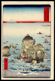
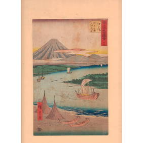
Utagawa HIROSHIGE I (1797-1858): Fuji seen from Futami Bay in Ise ProvinceJasper524.5(9.8k)See Sold PriceFeb 28, 2024
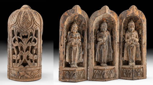
19th C. Chinese Folding Wood Travel Altar, 3 GuanyinArtemis Fine Arts4.8(1.4k)See Sold PriceFeb 26, 2024
ANTIQUE 19TH C DUTCH CITYSCAPE WATERCOLOR PAINTINGAntique Arena Inc.4.5(866)See Sold PriceMar 09, 2024
(4) Chinese Scrolls, Mountain LandscapeWilliam Bunch Auctions & Appraisals4.6(878)See Sold PriceFeb 27, 2024
Asian Watercolor and Ink Painting on Paper, Cherry BlossomsLion and Unicorn4.8(1.9k)See Sold PriceMar 14, 2024
Hiroshige (Japanese, 1797-1858) Woodblock Print, EjiriLion and Unicorn4.8(1.9k)See Sold PriceMar 14, 2024
Orientalist Oil Painting, Portrait of a Woman with TurbanLion and Unicorn4.8(1.9k)See Sold PriceMar 14, 2024


![Hondius [Family]. Nova Europae Descriptio. c.1630. (1 of 6)](https://p1.liveauctioneers.com/179/159352/80417886_1_x.jpg?height=282&quality=70&version=1578687793)


![Magni Mogolis Imperium... [ca. 1720]. (1 of 5)](https://p1.liveauctioneers.com/179/49347/23134529_1_x.jpg?height=282&quality=70&version=1388425910)