ATLAS of ANTIENT GEOGRAPHY by SAMUEL BUTLER 1843John McInnis Auctioneers,LLC4.6(504)See Sold PriceFeb 24, 2024
18TH C. ANTIQUE MAP: FRENCH & INDIAN WAR, FRAMEDThomaston Place Auction Galleries4.4(389)See Sold PriceFeb 24, 2024
Rand McNally Railroad Map Cabinet w/ 21 Railroad MapsRail & Road Auctions4.6(165)See Sold PriceMar 08, 2024
Keith Haring - Ink on New York Map, Best Buddies, Inscribed, Signed, and DatedSapphire Auction Gallery4.1(67)See Sold PriceMar 02, 2024
LATE 17TH C. FRENCH MAP OF THE NEW WORLD BY ALEXIS-HUBERT JAILLOT (1632-1712)Thomaston Place Auction Galleries4.4(389)See Sold PriceFeb 24, 2024
Central Railroad of New Jersey Map of Sandy Hook Route-ca. 1903JM Hobby Supply and Railroad Artifact Auctions4.4(126)See Sold PriceFeb 24, 2024
Lot of Six Mixed Atlas Box Cars-HO Scale-New in BoxJM Hobby Supply and Railroad Artifact Auctions4.4(126)See Sold PriceFeb 25, 2024
Rand McNally/Santa Fe Railroad Map of Iowa-1912JM Hobby Supply and Railroad Artifact Auctions4.4(126)See Sold PriceFeb 24, 2024
NICOLAES VISSCHER (NETHERLANDS, 1618-1709) MAP OF THE NEW WORLDThomaston Place Auction Galleries4.4(389)See Sold PriceFeb 24, 2024
17TH C. WORLD MAP BY NICOLAES VISSCHER (NETHERLANDS, 1618-1709)Thomaston Place Auction Galleries4.4(389)See Sold PriceFeb 24, 2024
Lot of Six Mixed Atlas Cabooses-HO Scale-New in BoxJM Hobby Supply and Railroad Artifact Auctions4.4(126)See Sold PriceFeb 25, 2024
1607 Engraved Map by J. Norden and W. Kip "Cantivm Quod1607 Engraved Map by John Norden (1548-1625) and William Kip Entitled "Cantivm Quod Nunc Kent" | A Map of the County of Kent | 11.5" H x 15" W | Latin text to reverse | Published in Camden's BritanniaSee Sold Price
1607 Engraved Map "Cantivm Quod Nunc Kent" Norden/Kip1607 Engraved Map by John Norden (1548-1625) and William Kip Entitled "Cantivm Quod Nunc Kent" | A Map of the County of Kent | 11.5" H x 15" W | Latin text to reverse | Published in Camden's BritanniaSee Sold Price
1607 Engraved Map by John Norden and William Kip1607 Engraved Map by John Norden (1548-1625) and William Kip (1588 - 1635) Entitled "Cantivm Quod Nunc Kent" | A Map of the County of Kent | 11.5" H x 15" W | Latin text to reverse | Published in CamdSee Sold Price
1607 Engraved Map by John Norden and William Kip1607 Engraved Map by John Norden (1548-1625) and William Kip (1588 - 1635) Entitled "Cantivm Quod Nunc Kent" | A Map of the County of Kent | 11.5" H x 15" W | Latin text to reverse | Published in CamdSee Sold Price
1607 Engraved Map by John Norden and William Kip1607 Engraved Map by John Norden (1548-1625) and William Kip (1588 - 1635) Entitled "Cantivm Quod Nunc Kent" | A Map of the County of Kent | 11.5" H x 15" W | Latin text to reverse | Published in CamdSee Sold Price
1607 Engraved Map by John Norden and William Kip1607 Engraved Map by John Norden (1548-1625) and William Kip (1588 - 1635) Entitled "Cantivm Quod Nunc Kent" | A Map of the County of Kent | Double-sided, Latin text to reverse | Published in Camden'sSee Sold Price
1607 Engraved Map by John Norden and William Kip1607 Engraved Map by John Norden (1548-1625) and William Kip (1588 - 1635) Entitled "Cantivm Quod Nunc Kent" | Encased both sides in glass showing map and verso text of Camden's Britannia | Latin textSee Sold Price
SoldNorden (J) and W. Kip. Hertfordiæ ComitatusNorden (John) and William Kip. Hertfordiæ Comitatus,Hertfordshire with strapwork title cartouche, engraved map, 285 x 350mm., central vertical fold, split, with small surface abrasion, one orSee Sold Price
Norden (John) and William Kip. Cantium quod nunc KNorden (John) and William Kip. Cantium quod nunc Kent,strapwork title and key cartouches above, large compass rose lower right, engraved map with original hand-colouring, 285 x 385mm., centralSee Sold Price
SoldA C17th hand coloured engraved map of Surrey by JohnA C17th hand coloured engraved map of Surrey by John Norden, 'Surrey olim sedes Regnorum', showing Surrey and surrounding counties, engraved by W. Kip, plate no. 9, 15" x 11"See Sold Price
SoldWillem Kip, Dutch act 1588-1635- ''SuffolciaeWillem Kip, Dutch act 1588-1635- ''Suffolciae Comitatus'' after Christopher Saxon, c.1607-1637; hand-coloured engraved map, 27.5x37.9cm: J C Walker, British 19th century- ''Suffolk''; hand-coloured enSee Sold Price
1710 HISTORY by LIVY 10 volumes Historiarum quod extat antique VELLUM BINDINGLivius, T. Historiarum quod extat. Ed. J. Clericus. Amsterdam/ Utrecht, H. Wetstenius/ W. van de Water; 1710 10 volumes., 10 engr. frontispieces by i.a. J. GOEREE, 14 folding engraved maps, original bSee Sold Price
SoldWilliam Kip & John Norden map of Kent, CANTIUM QuodWilliam Kip & John Norden map of Kent, CANTIUM Quod nunc Kent, coloured engraving, circa 1637, H.28cm W.38cmSee Sold Price
SoldWILLIAM KIP AFTER JOHN NORDEN HAND COLORED MAPWILLIAM KIP AFTER JOHN NORDEN, HAND COLORED MAP, H 11", W 14 7/8", "CANTIUM QUOD NUNC KENT":Parts of Essex and Parts of Middlesex, London. Hand colored. Retailed by H. S. Ward, 2 Parkside, Sussex. FraSee Sold Price
SoldWILLIAM KIP AFTER JOHN NORDEN HAND COLORED MAPWILLIAM KIP AFTER JOHN NORDEN, HAND COLORED MAP, H 11", W 14 7/8", "CANTIUM QUOD NUNC KENT":Parts of Essex and Parts of Middlesex, London. Hand colored. Retailed by H. S. Ward, 2 Parkside, Sussex. FraSee Sold Price
SoldSaxton (Christopher) and William Kip. - Bedfordengraved county map with hand-colouring, 280 x 335mm., trimmed on the platemark and laid on support, a small hole near central vertical fold, retouched, 1607 or later § Cary (J.) A Map of Surry froSee Sold Price
Blaeu (J & W) Guinea[Blaeu (J & W)] Guinea, engraved map of the coast of Guinea, the interior with elephants, lions, and monkeys, numerous ships, decorative cartouche, with full original hand-colouring, 425 x 535See Sold Price
Sold Ellicott, plat map of the District of Columbia and theArtist: Variation of Ellicott's first map, engraved by W. J. Stone. Title: Map Of The City Of Washington In The District Of Columbia: Established as the Permanent Seat of the Government of the UnitedSee Sold Price
SoldTwo Early Framed Engraved MapsA lot of two early hand-colored engraved maps to include a W. J. Bleau map of Amsterdam, ca. 1634-1635, "Sabaudia Ducatus Savoye", together with a John Speed map of Britain, ca. 1611-1614, "DevonshireSee Sold Price
SoldBlaeu (J & W) Turcicum ImperiumBlaeu (J & W) Turcicum Imperium, engraved map of Asia, showing part of Europe, Turkey, Egypt, and Arabia, with decorative cartouche, and hand-colouring, 415 x 520mm., Dutch text on verso, someSee Sold Price
Sold[Blaeu (J & W)] Comitatus NorthantonensisNorthamptonshire.- [Blaeu (J & W)] Comitatus Northantonensis, engraved map of Northamptonshire, pictorial cartouche, coats-of-arms, with hand-colouring, 415 x 495mm., French text on verso, teaSee Sold Price
SoldMilton, W. C1825 Hand Col Map. Spain & PortugalHand Colored Copper Engraved Map Published C1825 by J. McGowan, London. Engraved W. Milton. Paper Size: 10.5 x 8 inch (27 x 21cm) Good ConditionSee Sold Price
Sold[Blaeu (J & W)] Fifae Pars Orientalis[Blaeu (J & W)] Fifae Pars Orientalis, engraved map of Fife and the Firth of Forth, with decorative cartouche, and hand-colouring, 420 x 530mm., French text on verso, window mounted, [AmsterdaSee Sold Price
[Blaeu (J & W)] Candia olim Creta[Blaeu (J & W)] Candia olim Creta, engraved map of Crete, ornamental cartouche and ships, with hand-colouring, 385 x 530mm., Dutch text on verso, small rust mark, [Amsterdam], [c.1650]See Sold Price
HOUDINI (Erik Weisz, 1874 – 1926). Engraved Houdini Letterh...Potter & Potter Auctions4.6(544)See Sold PriceFeb 24, 2024
Vintage County Map Of NY State Plate EngravingThe Benefit Shop Foundation Inc.4.3(2.9k)See Sold PriceFeb 28, 2024
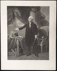
George Washington. 5 prints. 19th century. To include: 1) Large engraved portrait after StuartTremont Auctions4.6(294)See Sold PriceFeb 25, 2024
Large 19th century American prints. To include: Engraved portrait of Ulysses S. Grant by W.E.Tremont Auctions4.6(294)See Sold PriceFeb 25, 2024
1855 Map of New York & Erie Railroad and 1917 Trespassing On Railway Property Is A MisdemeanorRail & Road Auctions4.6(165)See Sold PriceMar 07, 2024
Pair of Early Railroad Maps - 1874 Delaware, Lackawanna & Western and 1876 Pennsylvania RailroadRail & Road Auctions4.6(165)See Sold PriceMar 07, 2024
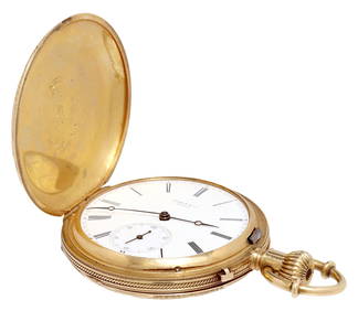
ESTATE SWISS TISSOT & CO. LADY'S 18KT GOLD HUNTER CASE POCKET WATCHAustin Auction Gallery4.7(1.2k)See Sold PriceFeb 25, 2024
1738 BIBLE in DUTCH ILLUSTRATED w/ MAPS MASSIVE FOLIO in DUTCH antique BIBLIAJasper524.5(9.8k)See Sold PriceFeb 27, 2024
1675 ELZEVIER JULIUS CAESAR antique ILLUSTRATED w/ MAPS ROMAN HISTORYJasper524.5(9.8k)See Sold PriceFeb 27, 2024
Birmingham.- Commercial map.- Smith (J. Pigott) To the Right Honourable William Earl of Dartmouth...Forum Auctions4.3(53)See Sold PriceFeb 29, 2024
Kent & Sussex.- Moss (W.G.) The History and Antiquities of the Town and Port of Hastings, 1824; andForum Auctions4.3(53)See Sold PriceFeb 29, 2024
First 50 plates from Audubon's Quad Quarto (all in Vol. I)PBA Galleries4.7(383)See Sold PriceMar 07, 2024
Large Bird Print by Bowen & Co. & OystercatcherKeystone Auction LLC4.6(927)See Sold PriceMar 01, 2024
Antique Map - Views on the coast of Asia. J. Webber del. Engraved after J. Webber and W. Bligh.Proverde Auctions4.3(3)See Sold PriceFeb 28, 2024


![[Blaeu (J & W)] Comitatus Northantonensis (1 of 1)](https://p1.liveauctioneers.com/410/3027/1300484_1_x.jpg?height=282&quality=70)

![[Blaeu (J & W)] Fifae Pars Orientalis (1 of 1)](https://p1.liveauctioneers.com/410/3027/1300492_1_x.jpg?height=282&quality=70)
![[Blaeu (J & W)] Candia olim Creta (1 of 1)](https://p1.liveauctioneers.com/410/3027/1300237_1_x.jpg?height=282&quality=70)