ATLAS of ANTIENT GEOGRAPHY by SAMUEL BUTLER 1843John McInnis Auctioneers,LLC4.6(502)See Sold PriceFeb 24, 2024
18TH C. ANTIQUE MAP: FRENCH & INDIAN WAR, FRAMEDThomaston Place Auction Galleries4.4(386)See Sold PriceFeb 24, 2024
Rand McNally Railroad Map Cabinet w/ 21 Railroad MapsRail & Road Auctions4.6(165)See Sold PriceMar 08, 2024
Keith Haring - Ink on New York Map, Best Buddies, Inscribed, Signed, and DatedSapphire Auction Gallery4(67)See Sold PriceMar 02, 2024
LATE 17TH C. FRENCH MAP OF THE NEW WORLD BY ALEXIS-HUBERT JAILLOT (1632-1712)Thomaston Place Auction Galleries4.4(386)See Sold PriceFeb 24, 2024
Central Railroad of New Jersey Map of Sandy Hook Route-ca. 1903JM Hobby Supply and Railroad Artifact Auctions4.4(126)See Sold PriceFeb 24, 2024
Lot of Six Mixed Atlas Box Cars-HO Scale-New in BoxJM Hobby Supply and Railroad Artifact Auctions4.4(126)See Sold PriceFeb 25, 2024
Rand McNally/Santa Fe Railroad Map of Iowa-1912JM Hobby Supply and Railroad Artifact Auctions4.4(126)See Sold PriceFeb 24, 2024
NICOLAES VISSCHER (NETHERLANDS, 1618-1709) MAP OF THE NEW WORLDThomaston Place Auction Galleries4.4(386)See Sold PriceFeb 24, 2024
17TH C. WORLD MAP BY NICOLAES VISSCHER (NETHERLANDS, 1618-1709)Thomaston Place Auction Galleries4.4(386)See Sold PriceFeb 24, 2024
Lot of Six Mixed Atlas Cabooses-HO Scale-New in BoxJM Hobby Supply and Railroad Artifact Auctions4.4(126)See Sold PriceFeb 25, 2024
1541 Ptolemaic map of Central AsiaTitle: [Title on Verso] Tabula Septima Asiae Complectitur Margianam, Bactrianam, Sogdianam, Sacas, & Scythiam, Intra Imaum Montem Map maker: Laurent Fries, Claudii Ptolemaei Alexandrini Geographicae��See Sold Price
Fries: Antique Ptolemaic Map of Central Asia, 1541Title: [Title on Verso] Tabula Septima Asiae Complectitur Margianam, Bactrianam, Sogdianam, Sacas, & Scythiam, Intra Imaum Montem. 1541 Ptolemaic map of Central Asia Map maker: Laurent Fries, ClaudiiSee Sold Price
SoldPtolemaic map of central Asia 1541Heading: Author: Ptolemy, Claudius / Lorenz Fries Title: Tabula Septima Asiae Complectitur Margianam, Bactriniam, Sogdianam, Sacas, & Scythiam intra Imaum montem - title from reverse Place Published:See Sold Price
Asia.- Pakistan, Afghanistan & Western India.- MercatorAsia.- Pakistan, Afghanistan & Western India.- Mercator (Gerard) Asiae IX Tab:, Ptolemaic map of Central Asia, centered on the Indus River, decorative title cartouche in the lower right, engraving onSee Sold Price
SoldAsia.- Caspian Sea.- Fries (Lorenz) Tabula VII Asiae,Asia.- Caspian Sea.- Fries (Lorenz) Tabula VII Asiae, Ptolemaic map of Central Asia, woodcut on laid paper with watermark of an encircled anchor with heart [cf. Briquet 585, datable to 1530s and earliSee Sold Price
MAP - Caucasus & Central Asia. MaginiCaucasus & Central Asia. Ptolemy/Magini, Tabula Asiae II, 1621 (published). Black & White. This Ptolemaic map, presented on a trapezoidal projection, presents a slice of the ancient world known as SarSee Sold Price
Fries (Laurent) - Asia Tabula Quinta,ptolemaic map of Persia and Mesopotamia, woodcut map, 305 x 500mm., Latin text verso with title, central vertical fold, minor handling creases, mostly marginal, [Strasbourg], 1522-41.See Sold Price
SoldFries (Laurent) - Tabu. Nova Asiae Mi.ptolemaic map of Asia Minor and Cyprus, title banderole in upper margin, woodcut map with original hand-colouring, 300 x 385mm., Latin text verso within ornate woodcut borders, central vertical fold,See Sold Price
-. Fries (Laurent) - Tabu. Nova Asiae Mi.ptolemaic map of Asia Minor and Cyprus, title banderole in upper margin, woodcut map with original hand-colouring, 300 x 385mm., Latin text verso within ornate woodcut borders, central vertical fold,See Sold Price
SoldPtolemy: Map of Bactria Scythia North India, 1597Map: Tabula Asiae VIII Cartographer: Ptolemy, Magini / Porro, P.Keschedt Place & Date: Cologne / 1597 Size: 6 3/4" x 5 1/4" Condition: b&w; overall age toning The eighth Ptolemaic Asia map from the MaSee Sold Price
SoldSeutter, Hand Colored Map, Central Asia, 18th C.German, circa 1770. "Imperi Magni Mogolis sive Indici Padschach"-circa 1740, hand colored copperplate cartographic engraving by Georg Matthäus Seutter (German, 1678-1757) published in Ausburg. A GermSee Sold Price
Britain 1841 - map - central ASIA - asia-veteribusTitle/Content of Map: Britain 1841 - map - central ASIA - asia-veteribus Nota, cum Insulis. Date Printed: 1841s Material/Medium: Engraving Provenance: E.P.Williams,Eton and at the Eton Warehouse, LondSee Sold Price
MAP, Central Asia, SansonCentral Asia. Nicolas Sanson, Scythia, Serica Regio Bactriana, 1655 (dated). Hand Color. This handsome classical map depicts the region stretching from Ukraine to China. It is finely engraved to showSee Sold Price
MAP - Central Asia. Ptolemy/MercatorCentral Asia. Ptolemy/Mercator, Asiae VII Tab:, 1618 (published). Hand Color. This fine copper engraved map covers Central Asia east of the Caspian Sea and what is now Turkestan, the Steppes, AfghanisSee Sold Price
Antique Original Map - Central Asia - Tibet - India - Pakistan - AfghanistanDiscover the Timeless Beauty of "Indien & Inner-Asien, Nordliches Bl": An Exquisite Cartographic Gem. This exquisite cartographic masterpiece invites you on a journey through the enchanting lands of ISee Sold Price
MAP - Central Asia. BonneCentral Asia. Rigobert Bonne, Carte de la Tartarie Independante qui Comprend le Pays des Calmuks, Celui des Usbeks, et le Turkestan..., 1771 (circa). Hand Color. This beautifully engraved map centersSee Sold Price
MAP, Central Asia, ArrowsmithCentral Asia. John Arrowsmith, Central Asia; Comprising Bokhara, Cabool, Persia, the River Indus, & Countries Eastward of It..., from London Atlas, 1834 (dated). Hand Color. This map of Central Asia iSee Sold Price
MAP - Central Asia. MercatorCentral Asia. Ptolemy/Mercator, Asiae VII Tab:, 1618 (published). Hand Color. This fine copper engraved map covers Central Asia east of the Caspian Sea and what is now Turkestan, the Steppes, AfghanisSee Sold Price
SoldJean-Baptiste Louis Clouet: Central Asia 1787Map: Central Asia De La Tartarie Maker: Jean-Baptiste Louis Clouet From Géographie Moderne Origin: Paris Date: 1787 Medium: Engraving hand-colored at publication Sheet Size: 19.75 x 26.75 inches No RSee Sold Price
Central Asia. Trans-Caspian Aral Sea Khiva BokharaTITLE/CONTENT OF MAP: 'Central Asia' DATE PRINTED: 1896 IMAGE SIZE: Approx 36.0 x 50.0cm, 14 x 19.75 inches (Large); Please note that this is a folding map. TYPE: Large (folio) antique atlas map CONDISee Sold Price
Stanford: Antique Map Of Central Asia, 1896TITLE/CONTENT OF MAP: 'Central Asia' Trans-Caspian Aral Sea Khiva Bokhara Sirdaria DATE PRINTED: 1896 IMAGE SIZE: Approx 36.0 x 50.0cm, 14 x 19.75 inches (Large); Please note that this is a folding maSee Sold Price
Stanford: Antique Map of Central Asia, 1896Title/Content of Map: 'Central Asia' Trans-Caspian Aral Sea Khiva Bokhara Sirdaria Date Printed: 1896 Image Size: Approx 36.0 x 50.0cm, 14 x 19.75 inches (Large); Please note that this is a folding maSee Sold Price
Johnston: Antique Map of Central Asia, 1912Title/Content of Map: 'Central Asia' Aral Sea Turkestan Khiva Bukhara Samarkand. Date Printed: 1912 Image Size: Approx 35.0 x 43.5cm, 13.75 x 17.25 inches (Large); Please note that this is a folding mSee Sold Price
Central Asia. Trans-Caspian Aral Sea Khiva BokharaTITLE/CONTENT OF MAP: 'Central Asia' DATE PRINTED: 1896 IMAGE SIZE: Approx 36.0 x 50.0cm, 14 x 19.75 inches (Large); Please note that this is a folding map. TYPE: Large (folio) antique atlas map CONDISee Sold Price
MAP - PIETER SCHENK / VALK / JANSSEN Hand Colored superb Map Central Italy c1702Luis Porretta Fine Arts4.3(10)See Sold PriceMar 02, 2024
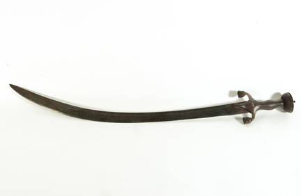
Rare Khanjar sword, 17th century Central Asia, Afghanistan, in steelTemplum Fine Art Auctions4.3(8)See Sold PriceFeb 28, 2024
TURKMEN CENTRAL ASIA SILVER CARNELIAN TRIBAL BELTAntique Arena Inc.4.5(852)See Sold PriceJun 15, 2024
TURKMEN CENTRAL ASIA SILVER CARNELIAN TRIBAL BELTAntique Arena Inc.4.5(852)See Sold PriceJun 15, 2024
TURKMEN CENTRAL ASIA SILVER CARNELIAN TRIBAL HEADDRESSAntique Arena Inc.4.5(852)See Sold PriceJun 15, 2024