Poster "Les jardins de Paris", illustrated map and plan of Paris with its parcs, gardens, monuments,Proverde Auctions4.3(3)See Sold PriceFeb 28, 2024
WEST CENTRAL AFRICA. Congo Angola Gabon Cameroon Sao Tome. MALLET 1683 old mapJasper524.5(9.8k)See Sold PriceFeb 28, 2024
1513 Tabula Moderna IndiaeBy: Martin WaldseemüllerDate: 1513 (Published) StrassburgDimensions: 15.94 x 21.46 inches (40.5 cm x 54.5 cm)An early and rare woodcut map regarded as the first modern printed map of Asia. This exaSee Sold Price
1513 Tabula Moderna IndiaeBy: Martin Waldseemüller Date: 1513 (Published) Strassburg Dimensions: 15.94 x 21.46 inches (40.5 cm x 54.5 cm) This early and rare woodcut map is thought to be the first modern printed map of AsiaSee Sold Price
SoldTabula Moderna IndiaeClaudius Ptolemaeus (after 83-168). Straussburg: Johann Schott, 1513. Woodcut map with original hand color. 17 1/2 x 23 1/4 inches sheet. First modern map of India .Fine woodcut map of modern India, bSee Sold Price
SoldWaldseemuller (Martin) Tabula Moderna Indiae[Waldseemuller (Martin)] Tabula Moderna Indiae,showing the Horn of Africa, part of the Arabian peninsula, South East Asia, including India, Sri Lanka and several islands of the Indian Ocean, SSee Sold Price
SoldWaldseemuller Modern SpainWaldseemuller, Martin (1470-1520). Tabula Moderna et Nova Hispanie. Woodcut. Strasbourg, 1513. 20 1/2" x 24 1/2" sheet, 31 1/2" x 35" framed. The first modern map of Spain, showing the Azores and theSee Sold Price
SoldMartin Waldseemuller Ptolemy Map of North AfricaMartin Waldseemuller (1470-1520)/ Claudius Ptolemy (ca. 100 CE-ca. 170 CE), "Tabula Moderna Prime Partis Aphricae," Strassburg, ca. 1513. This hand colored map of northern Africa is from WaldseemullerSee Sold Price
SoldFirst Edition Waldseemuller Map of FranceTabula Moderna Gallie. Martin Waldseemuller (1473-1520). Woodcut. Strasbourg, 1513. 17 1/2 x 23 inches sheet. First Edition Waldseemuller Map of ”Modern” France from what is considered to be the mSee Sold Price
Waldseemuller's First Modern Map of ItalyTabula Moderna Italie. Martin Waldseemuller (1470-1520). Woodcut. Strasbourg, 1513. 20 1/2 x 24 1/2 inches sheet, 31 1/2 x 35 inches framed. First modern map of Italy from the First Modern Atlas. OneSee Sold Price
SoldWaldseemuller Map of Modern GermanyTabula Moderna Germanie. Martin Waldseemuller (1470-1520). Woodcut engraving with original hand color. Strassburg: Johannes Schott, 1513. 23 3/8 x 17 3/4 inches sheet. One of the first true maps of ��See Sold Price
SoldTabula Indiae Orientallis. Emendata a F. de Wit.Tabula Indiae Orientallis. Emendata a F. de Wit. Toannes Lhuilier Fecit, 1662 - 18" x 42"See Sold Price
SoldIndia.- Münster (Sebastian) Tabula Indiae X, earlyIndia.- Münster (Sebastian) Tabula Indiae X, early Ptolemaic map of India from Münster's 'Geographia Universalis', woodcut with early hand-colouring on laid paper without watermark, sheet 31See Sold Price
SoldTabula Indiae Orientalis byFrederick de Wit Amsterdam, 1662, de Wit's attractive hand-colored map of Southeast Asia, engraved by Joannas Lhulier, this map served as a prototype for Speed's map of the East Indies, cartouche withSee Sold Price
Sold1662 deWit Map of Southeast Asia -- Tabula IndiaeReserve Reduced! Title/Content of Map: 1662 deWit Map of Southeast Asia -- Tabula Indiae Orientalis Date: 1662, Amsterdam Cartographer: F de Witt Size: 18 X 22.2 in. This is a outstanding larger map oSee Sold Price
SoldFrederick De Wit, Dutch 1610-1698- ''Tabula IndiaeFrederick De Wit, Dutch 1610-1698- ''Tabula Indiae Orientalis'', publ. 1662; hand colour engraved map, 46x57cm: Sidney Hall, British 1788-1831- ''China'', publ. by Longman, Rees, Orme, Brown & Green,See Sold Price
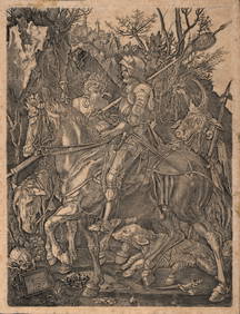
Sold[MAP] Tabula Moderna Prime Partis Aphricae[MAP] Tabula Moderna Prime Partis Aphricae Printed map. Fading. Framed, 19 x 25 3/4 inches. No place, no dateSee Sold Price
SoldIndien-Indonesien-Philippinen: Tabula Indiae Orien- Philippinen. Tabula Indiae orientalis. Kupferstich mit zeitgenöss. kolorierter figürlicher Kartusche und kleiner Windrose sowie mit zeitgenöss. Grenzkolorit. 45,8 x 56,7 cm. Joannes Lhuilier feciSee Sold Price
FRANCOIS VALENTIJN Tabula Indiae Oreintalis et RegnorumFRANCOIS VALENTIJN Tabula Indiae Oreintalis et Regnorum Adjacentium 51 x 67.2 cm (20 x 26.5 in) Scarce chart by Francois Valentijn from his monumental Oud et Nieuw Ost Indien showing the Philippines pSee Sold Price
1525 Ptolemy/Fries Map of North Africa -- II Tabula Moderna AphriceTitle: 1525 Ptolemy/Fries Map of North Africa -- II Tabula Moderna Aphrice Cartographer: Ptolemy/Fries Year / Place: 1525, Strassburg Map Dimension (in.): 12.5 X 17.6 in. This is a lovely and scarce wSee Sold Price
India.- Wit (Frederick de) - Tabula Indiae Orientalisafter de Wit, by J. L'Huilier, engraved map of the East Indies, with hand-colouring, 460 x 570 mm., on laid paper, with watermark of an elephant, central vertical fold, handling creases, spotting andSee Sold Price
1525 Ptolemy/Fries Map of North Africa -- II Tabula Moderna AphriceTitle: 1525 Ptolemy/Fries Map of North Africa -- II Tabula Moderna Aphrice Cartographer: Ptolemy/Fries Year / Place: 1525, Strassburg Map Dimension (in.): 12.5 X 17.6 in. This is a lovely and scarce wSee Sold Price
Soldde Wit: Map of Southeast Asia, 1670Map: Tabula Indiae Orientalis Cartographer: Frederick De Wit Place & Date: Amsterdam / 1670 Size: 22 1/4" x 18 1/4" Condition: light overall age-toning A highly decorative and beautifully colored lateSee Sold Price
SoldDe Wit map of India & Southeast Asia 1662Heading: Author: Wit, Frederick de Title: Tabula Indiæ Orientalis Place Published: Amsterdam Publisher: Date Published: 1662 Description: Copper-engraved map, hand-coloredSee Sold Price
SoldPtolemy Map of the Holy LandPTOLEMAEUS, Claudius (After 83- c.168 AD), translated by ANGELUS, Jacobus, edited by GERMANUS, Nicolaus. Tabula Moderna Terre Sancte. Woodcut engraving with original hand color. Ulm: Lienhart Holle, 1See Sold Price
SoldDe Wit Map of Southeast AsiaDE WIT, Frederick (1630-1706). Tabula Indiae Orientalis... Engraved map with original hand color in outline. Amsterdam, 1662. 21" x 24" sheet. This beautiful map of Southeast Asia was engraved by JoanSee Sold Price
17TH C. WORLD MAP BY NICOLAES VISSCHER (NETHERLANDS, 1618-1709)Thomaston Place Auction Galleries4.4(386)See Sold PriceFeb 24, 2024
NICOLAES VISSCHER (NETHERLANDS, 1618-1709) MAP OF THE NEW WORLDThomaston Place Auction Galleries4.4(386)See Sold PriceFeb 24, 2024
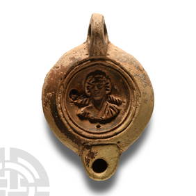
Roman Terracotta Lamp with Fighting GladiatorsTimeLine Auctions Ltd.4.5(183)See Sold PriceMar 05, 2024
Nova Totius Full Color Geographical World MapThe Benefit Shop Foundation Inc.4.3(2.9k)See Sold PriceFeb 28, 2024
Gruppo in terracotta raffigurante brigantiAste di Antiquariato Boetto4.3(47)See Sold PriceMar 06, 2024
Moderna Museet, Yves Klein, Alla Dagar Exhibition PosterCatalog Projects4.5(60)See Sold PriceFeb 28, 2024
1736 LARGE MAP OF SILESIA POLAND OPPAVIENSIS antique 25 by 34 3/4"Jasper524.5(9.8k)See Sold PriceFeb 27, 2024
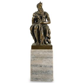
After Michelangelo (Italian, 1513) "Moses" Grand Tour Bronze SculptureAkiba Galleries4.7(1.7k)See Sold PriceFeb 29, 2024
Albrecht Durer (After) - Knight, Death and the Devil, c. the 18th Century.NCAG4.4(32)See Sold PriceMar 10, 2024
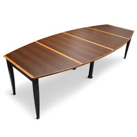
Tabula Magna Dining Table by Oscar Tosquets Blanca for Driade Aleph (1991)Jasper524.5(9.8k)See Sold PriceFeb 27, 2024
EPICTETUS ENCHIRIDIUS'S ANCIENT VELLUM TREATISE ON VEGETARIANISM, PUBLISHED IN 1655NY Elizabeth 4.3(84)See Sold PriceMar 03, 2024
(3) Consecutive 1963 $2 Legal Tender Notes Fr.1513 PMG Superb Gem Uncirculated 67EPQBK Auctions4.7(1.4k)See Sold PriceFeb 24, 2024
GIO PONTI attributed. Game table probable Casa Moderna execution, Milan.Capitoliumart s.r.l.4(82)See Sold PriceMar 08, 2024
SOEMMERING, SAMUEL THOMAS.1755-1830. Tabula baseos encephali. Frankfurt: by the author, 1799.Bonhams4.1(305)See Sold PriceJun 18, 2024


![[MAP] Tabula Moderna Prime Partis Aphricae (1 of 1)](https://p1.liveauctioneers.com/292/8142/1390888_1_x.jpg?height=282&quality=70)