ATLAS of ANTIENT GEOGRAPHY by SAMUEL BUTLER 1843John McInnis Auctioneers,LLC4.5(505)See Sold PriceFeb 24, 2024
18TH C. ANTIQUE MAP: FRENCH & INDIAN WAR, FRAMEDThomaston Place Auction Galleries4.4(393)See Sold PriceFeb 24, 2024
Rand McNally Railroad Map Cabinet w/ 21 Railroad MapsRail & Road Auctions4.6(165)See Sold PriceMar 08, 2024
Keith Haring - Ink on New York Map, Best Buddies, Inscribed, Signed, and DatedSapphire Auction Gallery4(67)See Sold PriceMar 02, 2024
LATE 17TH C. FRENCH MAP OF THE NEW WORLD BY ALEXIS-HUBERT JAILLOT (1632-1712)Thomaston Place Auction Galleries4.4(393)See Sold PriceFeb 24, 2024
Central Railroad of New Jersey Map of Sandy Hook Route-ca. 1903JM Hobby Supply and Railroad Artifact Auctions4.4(127)See Sold PriceFeb 24, 2024
Lot of Six Mixed Atlas Box Cars-HO Scale-New in BoxJM Hobby Supply and Railroad Artifact Auctions4.4(127)See Sold PriceFeb 25, 2024
Rand McNally/Santa Fe Railroad Map of Iowa-1912JM Hobby Supply and Railroad Artifact Auctions4.4(127)See Sold PriceFeb 24, 2024
NICOLAES VISSCHER (NETHERLANDS, 1618-1709) MAP OF THE NEW WORLDThomaston Place Auction Galleries4.4(393)See Sold PriceFeb 24, 2024
17TH C. WORLD MAP BY NICOLAES VISSCHER (NETHERLANDS, 1618-1709)Thomaston Place Auction Galleries4.4(393)See Sold PriceFeb 24, 2024
Lot of Six Mixed Atlas Cabooses-HO Scale-New in BoxJM Hobby Supply and Railroad Artifact Auctions4.4(127)See Sold PriceFeb 25, 2024
11 maps by John Cary, 1801-1808, 1831.[British Counties] 11 Maps by John Cary. 1 fully hand colored, 10 have orig hand colored outline. ++ A New Map Of The County Of Leicester, Divided into Hundreds. Lon: C. Smith, 1808. ++ A Map Of NorthSee Sold Price
Sold11 maps of English counties and shires.[England] 11 maps. Cary, John. (1) “A New Map of Dorsetshire.” 1806. (2) “Northumberland.” (3) “Leicestershire.” 1801. (4) “Shropshire.” 1805. (5) â€See Sold Price
SoldJohn Cary: Lower Saxony Germany 1808Map: A New Map of the Circle of Lower Saxony (Germany) Maker: John Cary From Cary's New Universal Atlas Origin: London Date: 1808 (Map dated 1801) Medium: Engraving hand-colored at publication Sheet SSee Sold Price
SoldCary, John 1801 Map of England & WalesHand Colored Copper Engraved Map Published 1801, London for "The Field of Mars" Folds as issued. Paper Size: 10.5 x 8 inch (27 x 21cm) Some margin toning. A couple of tine margin splits on folds. OtheSee Sold Price
SoldSmith (Charles) Map of CumberlandSmith (Charles) A New Map of the County of Cumberland,engraved map with original outline hand-colouring, 495 x 440mm., central horizontal fold, slightly discoloured, 1808 Cary (John) A Map oSee Sold Price
SoldSmith (C) Map of the County of CumberlandSmith (Charles) A New Map of the County of Cumberland,engraved map with original outline hand-colouring, 495 x 440mm., central horizontal fold, slightly discoloured, 1808 Cary (John) A Map oSee Sold Price
SoldEarly 19th Century Map of PersiaMap titled "A New Map of Persia from the latest Authorities" by John Cary, engraver, 1801. Framed map measures 18" x 20.5" (sight) with frame measuring 25" x 27". Map exhibits vertical fold repair witSee Sold Price
Sold(2) EARLY MAPS FRANCE & DENMARK(lot of 2) Framed maps, comprising: (1) "A New Map of the Kingdom of Denmark Comprehending North and South Jutland, Zeeland, Fyen, Laaland and Part of Holstein" by John Cary, 1801, published by John CSee Sold Price
SoldFRAMED MAP, A NEW MAP OF THE KINGDOM OF DENMARKFramed map, "A New Map of the Kingdom of Denmark Comprehending North and South Jutland, Zeeland, Fyen, Laaland and Part of Holstein" by John Cary, 1801, published by John Cary, Engraver and Map SellerSee Sold Price
SoldJohn Cary, New Map of China. 1801John Cary, New Map of China from the latest authorities. London, 1801. Impression measures 19.75x21.75'' on approx 21x25'' sheet. Inventory '46' attached with adhesive at top center, light soiling thrSee Sold Price
SoldSHROPSHIRE MAP JOHN CARY FRAMED 1793 U.K.Original Shropshire map by John Cary. Dated Jan 1st, 1793. Slight wear to top left of map. Measures 16"x14 1/2" framed. Map measures 11"x9". Comes with original Atlas text page affixed to back of framSee Sold Price
Sold15 maps by John Cary. Handcolored outline.[Cary, John] 15 Maps. Lon: John Cary, cartouches 1799-1806. [Probably from the 1808 edition of “A New Universal Atlas.”] About 18” x 20” at outer edge of border, with variation. Orig hand-coloSee Sold Price
SoldA large coloured new map of Worcestershire 'dividedA large coloured new map of Worcestershire 'divided into hundreds' by John Cary dated 1801. Also a monochromatic map of the county of Derby by C&I Greenwood, published 1830. Two items.See Sold Price
SoldAFTER JOHN CARY, NEW MAP OF SUSSEX, C. 1801After John Cary (British 1754-1835), "A New Map of Sussex, Divided Into Hundreds, Exhibiting Its Roads, Rivers, Parks & C.", circa 1801, colored copper engraving, topographical map depicting the EngliSee Sold Price
Two Maps by John Cary (1754-1835), "A New Map of theTwo Maps by John Cary (1754-1835), "A New Map of the Circe of Lower Saxony," 1801; together with "A New Map of France, Division into Provinces," 1806, H.-1 9 1/2 in., W.- 22 1/2 in. and H.- 21 3/8 in.See Sold Price
Sold(4) EARLY ENGLISH ENGRAVED MAPS BY JOHN CARYHand-colored Engraved Atlas Folio Maps of Europe, including: 'Circle of Bavaria', 1799; 'County of Tyrol and the Republic of Venice; Duchy of Mantua &c &c', 1799; 'Bohemia and Moravia', 1801; 'CircleSee Sold Price
SoldJohn Cary Map, "A New Map of China" 1801, hand coloredJohn Cary Map, "A New Map of China" 1801, hand colored engraving, 21-1/2" x 25-1/2" sheet, discoloration, especially at lower marginSee Sold Price
SoldJohn Cary. a New Map of Scotland. 1801.Hand Colored Map. 21" x 25" with huge margins. Edge wear which can be easily matted out with large margins still present.See Sold Price
Sold1808 CARY JOHN (1754 - 1835) INCISIONE in bianco e nero1808 CARY JOHN (1754 - 1835) INCISIONE in bianco e nero con i confini colorati "Sicily" (cm 23 x 28,5) tratta da New universal atlas. Misure: cm 33,2 x 26See Sold Price
New Map of Scotland from the Latest Authorities, byTitle: New Map of Scotland from the Latest Authorities, by John Cary Publication Date: 1801-08-01 Cartographer: Cary, John Publisher: J. Cary Dimensions: 17.75 X 42 Additional Information: Two sheetsSee Sold Price
JOHN CARY CIRCLE OF SAXONY MAP 1801 18" X 20"JOHN CARY, CIRCLE OF SAXONY, MAP 1801 18" X 20", ENGRAVING:Published in London. John Cary engraver. Fold in center. Framed.See Sold Price
SoldCARY, SCOTLAND MAP, HAND COLOR ENG, C.1801Artist: John Cary, Title: A New Map of Scotland (in four parts), Printmaker: John Cary, Pub: John Cary, Date: C.1801, Medium: Hand-colored engraving, Paper size: 20 1/2 x 24 each, Inscribed: EngraverSee Sold Price
John Cary. 'A New Map of Bedfordshire.. 1801, with handJohn Cary. 'A New Map of Bedfordshire.. 1801, with hand tinted boundaries. 57x51cm.See Sold Price
19th C. European Maps - Austria, Saxony, HollandTHREE ANTIQUE EUROPEAN MAPS including: (1) John Cary (British, 1754-1835). "A New Map of the Circle of Austria, from the Latest Authorities." London, 1801. An attractive 1801 map of Austria by BritishSee Sold Price
17TH C. MAP OF THE BERKSHIRES BY JOHN SPEED, FRAMEDThomaston Place Auction Galleries4.4(393)See Sold PriceFeb 24, 2024
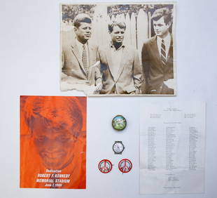
1969 R.F.K. MEMORIAL STADIUM DEDICATION MOMENTOSJohn McInnis Auctioneers,LLC4.5(505)See Sold PriceFeb 25, 2024
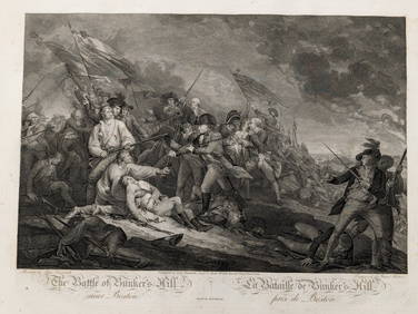
2 engravings of the Battle of Bunker's Hill. Early 19th century. 1) 1808 John Trumball publishedTremont Auctions4.5(297)See Sold PriceFeb 25, 2024
American Revolution prints. 19th century. To include: 1) "The Death of General Montgomery". FrenchTremont Auctions4.5(297)See Sold PriceFeb 25, 2024
John Bluck, act. 1791-1819 Handcolored Etching Aquatint View at Hastings signedGlobal Auctions Company4.3(36)See Sold PriceMar 03, 2024
LARGE FRAMED PAINTED TAPESTRY THE RAISING OF LAZARUS, 64" X 47.5"Austin Auction Gallery4.7(1.2k)See Sold PriceFeb 25, 2024
Map: A 19thC engraved map titled Gloucestershire from the Best Authorities, after John Cary. Approx.Claydon Auctioneers Ltd4.3(125)See Sold PriceFeb 26, 2024
Map: A 19thC engraved and hand coloured map of Buckingham titled A New Map of BuckinghamshireClaydon Auctioneers Ltd4.3(125)See Sold PriceFeb 26, 2024
Map: A 19thC engraved map of West Riding, titled A Map of the North Part of the West Riding ofClaydon Auctioneers Ltd4.3(125)See Sold PriceFeb 26, 2024
Medicine.- Kennedy (James) The History of the Contagious Cholera, first edition, 1831 & others (11)Forum Auctions4.3(53)See Sold PriceFeb 29, 2024
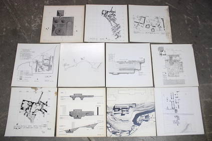
Set of 11 Mid Century Modern Architectural Plans & Site Map RenderingsPUBLIC SALE4.7(226)See Sold PriceMar 02, 2024
Sir John Gilbert A Convocation (Convocation of Clergy) 1878 etchingKCM Galleries4.7(164)See Sold PriceFeb 25, 2024
Cooke, George 1801 Antique Map. Germany divided into CirclesAlbion Auctions4.6(341)See Sold PriceMar 01, 2024
19TH C. SHAKER PENMANSHIP VERSE, JOHN B. GRIFFIN.William Smith Auctions4.6(147)See Sold PriceMar 06, 2024