SoldMAP OF NEW YORK CITY, 1865, HAND COLORED, FRAMED,PUBLISHED BY G.W. & C.B. COLTON, 172 WILLIAM ST, NEW YORK. SHOWS CREASE IN CENTER WITH SOME STAINING AND FOXING. 23 1/2" X 16".See Sold Price
SoldUnited States: 1882 Hand-Colored Map by G.W. & CUnited States: 1882 Hand-Colored Map by G.W. & C. Colton & Co., in Vintage Frame, See Sold Price
Sold1 piece. Hand Colored Engraved Map. Jansson, Jan1 piece. Hand Colored Engraved Map. Jansson, Jan. "Tabula Italia." Amsterdam, 1640. 18 x 21 1/4 inches; 457 x 540 mm. Margins repaired, small vertical tear at upper right edge. Vignette borders.See Sold Price
Sold1 piece. Hand-Colored Engraved Map. Speed, John.1 piece. Hand-Colored Engraved Map. Speed, John. The Kingdom of Scotland." (London): Sudbury & Humble, 1610. 15 x 20 1/8 inches; 390 x 511 mm. Old (orig.?) color. Moderately age toned, margins occasioSee Sold Price
Sold1 piece. Hand-Colored Engraved Map. A Map of Penn1 piece. Hand-Colored Engraved Map. A Map of Pennsylvania Exhibiting not only the Improved Parts of That Province,... Chiefly from the Late Map of W. Scull... La Pensilvanie en Trois Feuilles..." [ParSee Sold Price
Sold1 piece. Hand-Colored Engraved Map. De1 piece. Hand-Colored Engraved Map. Delisle, Guillaume. "L'Amerique Septentrionalis." Amsterdam: Covens and Mortier, [1730]. 18 7/8 x 22 7/8 inches; 480 x 580 mm, full margins. Old outline color, cartSee Sold Price
SoldLARGE ENGRAVING 1855 NEW YORK HARBOR ENGRAVED BY CLARGE ENGRAVING 1855 NEW YORK HARBOR ENGRAVED BY C MOTTRAM 1 Piece. Hand-colored Aquatint and Engraving. Mottram, C. after Hill, John W. "New York." New York: F. & W. Smith, 1855 Overall size: 47 by 6See Sold Price
SoldTHOMSON'S NEW GENERAL ATLAS MAPSTHOMSON'S NEW GENERAL ATLAS MAPS (23), 18'' X 24 1/4'', NOT FRAMED:Engraved and hand colored maps, c. 1827. Maps vary from two images on one page to larger images covering two pages. The map depictionSee Sold Price
Colton's Dollar Series of Sectional Maps, IllinoisMap: Colton’s Hand Colored Dollar Series of Sectional Maps. Illinois by Colton Publisher: G.W. & C.B. Colton, Rufus Blanchard Origin: Chicago Size: Elephant Folio, 32.25 inches high x 22 inches wideSee Sold Price
SoldOld Map of 1873 "Colton's Dakota"Old Map entitled "Colton's Dakota". Purchased by the consignor as "an original hand colored tinted map from circa 1873". Published by G.W. (and) C.B. Colton & Co. No. 172 William St. New York. At bottSee Sold Price
SoldTwo Mid 19th Century United States Framed Maps1. Hand colored map "United States of North America / North Central Sheet", depicting Midwest with Minnesota Territory pre-Dakota, c. 1863, drawn and engraved by T. Ettling, Weekly Dispatch Atlas; matSee Sold Price
Sold17th and 18th C. Maps of Florida and EnglandTwo 17th & 18th century maps. Item 1: Hand-colored and engraved map of West Florida, dated 1772. Titled "A Map of Part of West Florida, from Pensacola to the Mouth of the Iberville River, with a ViewSee Sold Price
SoldNicolas De Fer (1646-1720, French), "Carte De LaNicolas De Fer (1646-1720, French), "Carte De La Louisiane et De La Floride", hand colored engraved map, c. 1760, showing the Indian tribes, framed, H.- 13 1/2 in., W.- 8 7/8 insight 13" x 9".See Sold Price
SoldThree European Hand-Colored MapsThree Antique European Hand-Colored Maps , 18th c., incl.: "The Countie and Citie of Lyncolne Described with the Armes...", 15 in. x 20 in.; "Istria olim Iapidia", 15 in. x 19 1/2 in.; and "PrincipatuSee Sold Price
Sold2 Maps. Oxfordshire and Scotia Regnum.[Great Britain] 2 Maps. Hole, William. "Scotia Regnum." c. 1610. Engraved map. Hand colored. Image: 12 1/4" x 10 1/4". Framed: 19 1/2" x 17 1/2". ++ Speed, John. "Oxfordshire described with ye Citie aSee Sold Price
Sold1866 Map of Ireland - A.J. Johnson New YorkHand colored map of Ireland c.1866; A.J. Johnson; measures about 14 inches by 16 1/2 inchesSee Sold Price
Sold19th c. Hand-colored map19th c. Hand-colored map- ''Nouveau Plan du Port et de la ville D'Acapulco situee dans la Nouvelle Es Pagne sur la Cote de la Mer du Zud'', laid down, some age staining throughout. 16 1/4 x 22''See Sold Price
Sold3 18th C. maps incl. R. Vaugondy and J. BaylyItem 1: Robert de Vaugondy hand colored map "Amerique septen trionale." French, 1750. 6 3/8" H x 6 1/2" W. Item 2: Robert de Vaugondy hand colored map "Mappe Monde" French, 1750. 6 3/8" H x 12 1/8" W.See Sold Price
Sold17th C. Hand-Colored Map of DorsetshyreA circa 1662 hand-colored British map of "Dorsetshyre" by John Speed (1551-1629) and engraved by Jodocus Hondius. Has an inset map of Dorchester upper left. Framed under glass. Mat opening: 15-1/2in xSee Sold Price
Sold17th C. Hand-Colored Map of Tabula MagellanicaA 17th C. hand-colored engraved map of Tabula Magellanica, by William Blaeu. An important early map of South America showing the Strait of Magellan. Framed under glass. Mat opening: 16-1/4in x 21-1/2iSee Sold Price
Sold(4) Mid 19th c. hand colored maps of New YorkGrouping of four circa 1867 hand colored maps from the "Atlas of New York and Vicinity" by Beers, Ellis & Soule, the drawings from surveys by and under the direction of F.W. Beers, includes (1) PlansSee Sold Price
SoldHondius Map of LithuaniaHONDIUS, Henricus (1597-1651). / JANSSONIUS, Johannes (1588-1664). Magni Ducatus Lithuaniae. Engraved map with original hand color.Amsterdam c. 1645.19" x 22 1/2" sheet.Beautiful hand colored map of LSee Sold Price
SoldNicholas Sanson D'Abbeville engraved mapNicholas Sanson D'Abbeville- ''Le Royaume De France divite en Toute fes Provinces et fes Acquifition''- hand-colored engraved map, Paris, 18th c. 19 1/4 x 23''See Sold Price
SoldCity of New Orleans Aerial View Map, 19th c., hanCity of New Orleans Aerial View Map, 19th c., hand colored, framed, H.- 8 1/4 in., W.- 4 3/4 in.See Sold Price
GILBERT & BARKER TEN GALLON VISIBLE GAS PUMP RESTORED IN SHELL GASOLINE.Dan Morphy Auctions4.2(1.3k)See Sold PriceFeb 24, 2024
LARGE LATE 17TH C. DUTCH CHART OF CANADA, GREAT LAKES, NEW FRANCE, LABRADOR, HUDSON BAY, BY PIERREThomaston Place Auction Galleries4.4(393)See Sold PriceFeb 24, 2024
EARLY 18TH C. DUTCH CHART OF PACIFIC OCEAN BY FREDERIK DE WIT (1629-1706) WITH CALIFORNIA AS ANThomaston Place Auction Galleries4.4(393)See Sold PriceFeb 24, 2024
17TH C. ANTIQUE MAP SIEGE OF LA ROCHELLE, FRANCE, FRAMEDThomaston Place Auction Galleries4.4(393)See Sold PriceFeb 24, 2024
EARLY 18TH C. MAP OF ITALY, FRAMEDThomaston Place Auction Galleries4.4(393)See Sold PriceFeb 24, 2024
18TH C. ANTIQUE MAP: FRENCH & INDIAN WAR, FRAMEDThomaston Place Auction Galleries4.4(393)See Sold PriceFeb 24, 2024
17TH C. ENGLISH LINEAR MAP BY OGILBY, FRAMEDThomaston Place Auction Galleries4.4(393)See Sold PriceFeb 24, 2024
Currier & Ives Colored Lithograph On the OwagoGlobal Auctions Company4.3(36)See Sold PriceMar 03, 2024
Honore Daumier France 1808 -1879 Lithograph A Respected CitizenGlobal Auctions Company4.3(36)See Sold PriceMar 03, 2024
An early Dutch hand colored engraving map by Georg Balthasar Probst (1732-1801)Ostantix Auctions4.4(11)See Sold PriceFeb 27, 2024
Andreas Cellarius (1596-1665) Hand Colored 20th C Etching on Paper, Harmonica MacrocosmicaHughes Auctions4.4(166)See Sold PriceFeb 25, 2024
Johann Homann Hand-Colored Map Engraving, c. 1730Auctions at Showplace4.6(740)See Sold PriceMar 17, 2024
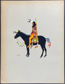
Kiowa Indian Art - Mopope: Kiowa Warrior on HorsebackTrillium Antique Prints & Rare Books4.5(32)See Sold PriceFeb 24, 2024
Kiowa Indian Art - Mopope: Kiowa Warrior and wifeTrillium Antique Prints & Rare Books4.5(32)See Sold PriceFeb 24, 2024