ATLAS of ANTIENT GEOGRAPHY by SAMUEL BUTLER 1843John McInnis Auctioneers,LLC4.5(505)See Sold PriceFeb 24, 2024
18TH C. ANTIQUE MAP: FRENCH & INDIAN WAR, FRAMEDThomaston Place Auction Galleries4.4(393)See Sold PriceFeb 24, 2024
Rand McNally Railroad Map Cabinet w/ 21 Railroad MapsRail & Road Auctions4.6(165)See Sold PriceMar 08, 2024
Keith Haring - Ink on New York Map, Best Buddies, Inscribed, Signed, and DatedSapphire Auction Gallery4(67)See Sold PriceMar 02, 2024
LATE 17TH C. FRENCH MAP OF THE NEW WORLD BY ALEXIS-HUBERT JAILLOT (1632-1712)Thomaston Place Auction Galleries4.4(393)See Sold PriceFeb 24, 2024
Central Railroad of New Jersey Map of Sandy Hook Route-ca. 1903JM Hobby Supply and Railroad Artifact Auctions4.4(127)See Sold PriceFeb 24, 2024
Lot of Six Mixed Atlas Box Cars-HO Scale-New in BoxJM Hobby Supply and Railroad Artifact Auctions4.4(127)See Sold PriceFeb 25, 2024
Rand McNally/Santa Fe Railroad Map of Iowa-1912JM Hobby Supply and Railroad Artifact Auctions4.4(127)See Sold PriceFeb 24, 2024
NICOLAES VISSCHER (NETHERLANDS, 1618-1709) MAP OF THE NEW WORLDThomaston Place Auction Galleries4.4(393)See Sold PriceFeb 24, 2024
17TH C. WORLD MAP BY NICOLAES VISSCHER (NETHERLANDS, 1618-1709)Thomaston Place Auction Galleries4.4(393)See Sold PriceFeb 24, 2024
Lot of Six Mixed Atlas Cabooses-HO Scale-New in BoxJM Hobby Supply and Railroad Artifact Auctions4.4(127)See Sold PriceFeb 25, 2024
"Western hemisphere". North & South America. Polynesia.TITLE/CONTENT OF MAP: 'Western hemisphere' The top image on the right hand side shows the entire map. To view a close up of the map showing the level of printed detail, please click on the bottom imagSee Sold Price
Western hemisphere. North / South America. Polynesia. THOMSON 1817 old mapTITLE/CONTENT OF MAP: 'Western hemisphere' DATE PRINTED: Published in 1817. Engraved in 1815; this date is marked on the map IMAGE SIZE: Approx 54.0 x 53.0cm, 21.25 x 20.75 inches (Large); Please noteSee Sold Price
Western hemisphere. North & South America. Polynesia. THOMSON 1830 old mapTITLE/CONTENT OF MAP: 'Western hemisphere' DATE PRINTED: 1830 IMAGE SIZE: Approx 55.5 x 53.5cm, 21.75 x 21 inches (Large); Please note that this is a folding map. TYPE: Antique early 19th century atlaSee Sold Price
"Western hemisphere". North & South America. Polynesia.TITLE/CONTENT OF MAP: 'Western hemisphere' The top image on the right hand side shows the entire map. To view a close up of the map showing the level of printed detail, please click on the bottom imagSee Sold Price
SoldThomson: Antique Map of the Western Hemisphere, 1817Title/Content of Map: 'Western hemisphere' North & South America. Polynesia. Date Printed: 1817 Image Size: Approx 55.0 x 52.5cm, 21.5 x 20.75 inches (Large); Please note that this is a folding map. TSee Sold Price
Thomson: Antique Map of North & South America, 1817Title/Content of Map: 'Western hemisphere' North & South America. Polynesia Date Printed: 1817 Image Size: Approx 55.0 x 52.5cm, 21.5 x 20.75 inches (Large); Please note that this is a folding map. TySee Sold Price
SoldTwo Mercator / Hondius Maps2 (Gerard) Mercator atlas maps, 1619 French Edition, handcolored copperplate engravings on paper. 1st item: America "L'Amerique" by Joducus Hondius, Western Hemisphere - North and South America. ShowsSee Sold Price
de la Tour: Antique Map of Western Hemisphere, 1771Title/Content of Map: 'Hémisphère Occidental' The Western Hemisphere: North and South America. The rumoured "Mer de l'Ouest" (inland Western Sea) within the western part of North America is marked,See Sold Price
de la Tour: Antique Map of Western Hemisphere, 1771TITLE/CONTENT OF MAP: 'Hémisphère Occidental' The Western Hemisphere: North and South America. The rumoured "Mer de l'Ouest" (inland Western Sea) within the western part of North America is marked,See Sold Price
de la Tour: Antique Map of Western Hemisphere, 1771Hémisphère Occidental' The Western Hemisphere: North and South America. The rumoured "Mer de l'Ouest" (inland Western Sea) within the western part of North America is marked, curiously with the "R[iSee Sold Price
Hémisphère Occidental. Western Hemisphere Americas.TITLE/CONTENT OF MAP: 'Hémisphère Occidental' The Western Hemisphere: North and South America. The rumoured "Mer de l'Ouest" (inland Western Sea) within the western part of North America is markSee Sold Price
Hémisphère Occidental. Western Hemisphere Americas.TITLE/CONTENT OF MAP: 'Hémisphère Occidental' The Western Hemisphere: North and South America. The rumoured "Mer de l'Ouest" (inland Western Sea) within the western part of North America is marked,See Sold Price
Desnos/de la Tour: Map of Western Hemisphere, 1771TITLE/CONTENT OF MAP: 'Hémisphère Occidental' The Western Hemisphere: North and South America. The rumoured "Mer de l'Ouest" (inland Western Sea) within the western part of North America is marked,See Sold Price
EARLY MAPS OF THE AMERICAS (2)Good pair of early nineteenth-century maps depicting the Americas, includes: hand-outlined lithograph map, 11' x 12 1/2', a depiction of the Western Hemisphere, including North and South America, NewSee Sold Price
Large Group of Various Art Books: AmericasLarge group of various art books pertaining to the western hemisphere, including: North, Central, and South AmericaSee Sold Price
SoldLarge Group of Various Art Books: AmericasLarge group of various art books pertaining to the western hemisphere, including: North, Central, and South AmericaSee Sold Price
Aspin: Antique Map of Western Hemisphere, 1832Title: North & South America; for the Elucidation of the Abbe Gaultier's Geographical Games. Aspin western hemisphere with proposed state of Franklinia and unusual boundaries Map maker: Jehoshaphat AsSee Sold Price
SoldMAP OF THE WESTERN HEMISPHERE BY A.L. SMITH 1894Hand colored and engraved map of north and south America. Matted, 14.75 x 10.75 inches. Not examined outside wrapping, appears excellent.See Sold Price
SoldC. 1850 J&C WALKER, MAP OF THE WESTERN HEMISPHEREA circular map of North and South America and their surrounding oceans. At lower left are statistics regarding animals on the globe and vegetables and lower right a table of the highest mountains. CreSee Sold Price
Aspin: Antique Map of North and South America, 1838Title/Content of Map: North and South America; Date Printed: 1838 Cartographer: ASPIN, JEHOSHOPHAT/N. R. HEWITT, sc. Size: 13.5X17 Simple child's map of the Western Hemisphere with a large inset of thSee Sold Price
SoldWestern HemisphereWestern Hemisphere, Henry Teesdale, 1848. A large hemispheral map of North and South America with a detailed treatment of the Pacific Islands. Greenland and the arctic land mass are incomplete. TexasSee Sold Price
SoldTWO MAPS OF THE WESTERN HEMISPHERE. Charte von America and Charte von Nord-America. Prague, 1818.TWO MAPS OF THE WESTERN HEMISPHERE. Charte von America and Charte von Nord-America. Prague, 1818. Two engraved maps with hand coloring, matted and framed, one showing North and South America and one sSee Sold Price
Sold17th Century Schenck Map of theWestern Hemisphere [America Septentrionalis Novissima/America Meridionalis Accuratissima,] by Pieter Schenck, published in Amsterdam, circa 1695, North and South America, California depicted as an islSee Sold Price
17th Century Hondius Map of theWestern Hemisphere [Septentrio America,] by Jodocus Hondius, published in Amsterdam, first published 1606, from [Mercator's Atlas,] showing North and South America with various sailing vessels and seaSee Sold Price
The Rolling Stones Bridges To Babylon Tour Original Promotional PosterShakespeare Auctions4.3(1)See Sold PriceFeb 25, 2024
Carey, pub. 1796 - Map of the Tennassee State formerly part of North Carolina (Tennessee)Trillium Antique Prints & Rare Books4.5(32)See Sold PriceFeb 24, 2024
Map: An 18thC engraved and hand coloured map of North America and South America, titled DeClaydon Auctioneers Ltd4.3(125)See Sold PriceFeb 26, 2024
1822 MAP of NORTH & SOUTH AMERICA GEOGRAPHICAL STATISTICAL HISTORICAL antiqueJasper524.5(9.9k)See Sold PriceFeb 27, 2024
Mexico, Central America and West Indies Physical PoliticalJasper524.5(9.9k)See Sold PriceFeb 27, 2024
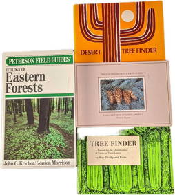
4 Ecology Of Eastern Forest & Tree Finder PaperbacksRapid Estate Liquidators and Auction Gallery4.5(1.1k)See Sold PriceFeb 25, 2024
Large Fossilized Tortoise Shell - Stylemys NebraskensisArtemis Fine Arts4.8(1.4k)See Sold PriceMar 01, 2024
Montana Paleocene Gingko Leaf Fossil in Stone MatrixArtemis Fine Arts4.8(1.4k)See Sold PriceMar 01, 2024