ATLAS of ANTIENT GEOGRAPHY by SAMUEL BUTLER 1843John McInnis Auctioneers,LLC4.5(505)See Sold PriceFeb 24, 2024
18TH C. ANTIQUE MAP: FRENCH & INDIAN WAR, FRAMEDThomaston Place Auction Galleries4.4(393)See Sold PriceFeb 24, 2024
Rand McNally Railroad Map Cabinet w/ 21 Railroad MapsRail & Road Auctions4.6(165)See Sold PriceMar 08, 2024
Keith Haring - Ink on New York Map, Best Buddies, Inscribed, Signed, and DatedSapphire Auction Gallery4(67)See Sold PriceMar 02, 2024
LATE 17TH C. FRENCH MAP OF THE NEW WORLD BY ALEXIS-HUBERT JAILLOT (1632-1712)Thomaston Place Auction Galleries4.4(393)See Sold PriceFeb 24, 2024
Central Railroad of New Jersey Map of Sandy Hook Route-ca. 1903JM Hobby Supply and Railroad Artifact Auctions4.4(127)See Sold PriceFeb 24, 2024
Lot of Six Mixed Atlas Box Cars-HO Scale-New in BoxJM Hobby Supply and Railroad Artifact Auctions4.4(127)See Sold PriceFeb 25, 2024
Rand McNally/Santa Fe Railroad Map of Iowa-1912JM Hobby Supply and Railroad Artifact Auctions4.4(127)See Sold PriceFeb 24, 2024
NICOLAES VISSCHER (NETHERLANDS, 1618-1709) MAP OF THE NEW WORLDThomaston Place Auction Galleries4.4(393)See Sold PriceFeb 24, 2024
17TH C. WORLD MAP BY NICOLAES VISSCHER (NETHERLANDS, 1618-1709)Thomaston Place Auction Galleries4.4(393)See Sold PriceFeb 24, 2024
Lot of Six Mixed Atlas Cabooses-HO Scale-New in BoxJM Hobby Supply and Railroad Artifact Auctions4.4(127)See Sold PriceFeb 25, 2024
... Sketch I Showing the Progress of the Survey in Section No.Ix [Gulf Coast of Texas]Publication Date: 1860 Title: ... Sketch I Showing the Progress of the Survey in Section No.Ix [Gulf Coast of Texas] Cartographer: U.S. COAST SURVEY Publisher: U.S. COAST SURVEY Height: 10 Width: 24.7See Sold Price
Sketch I Showing the Progress of the Survey in SectionTitle: Sketch I Showing the Progress of the Survey in Section No.9 [Texas Gulf Coast] Cartographer: ANONYMOUS Publication Date: 1853 Publisher: U.S. COAST SURVEY Size: 17.5Height - 21.6Width TriangulaSee Sold Price
SoldAN ANTIQUE RECONSTRUCTION ERA SURVEY MAP, "U.S. CoastAN ANTIQUE RECONSTRUCTION ERA SURVEY MAP, "U.S. Coast Survey, Sketch 1, Showing the Progress of the Survey in Section IX from 1848-1875," 1875, lithograph on paper, showing the Texas Gulf Coastline frSee Sold Price
Sketch G Showing the Progress of the Survey in SectionTitle: Sketch G Showing the Progress of the Survey in Section No. VII [Florida Gulf Coast] from 1849 to 1857 Publication Date: 1857 Cartographer: U.S. COAST SURVEY Publisher: U.S. COAST SURVEY Height:See Sold Price
Sketch G Showing the Progress of the Survey in SectionTitle: Sketch G Showing the Progress of the Survey in Section VII from 1849 to 1860. Publication Date: 1861 Cartographer: U.S. COAST SURVEY Publisher: GPO Height: 21 Width: 34.75 The Florida Gulf CoasSee Sold Price
SoldHand-Colored Lithograph Map of the Gulf of MexicoImpressive Hand-Colored Lithograph Map of the Gulf of Mexico, titled "U.S. Coast Survey, A.D. Bache Superintendent, Sketch H, Showing the Progress of the Survey in Section No. 8, 1846-1854", the map iSee Sold Price
SoldU S Coast Survey 1896 LG Map. New Orleans Texas Florida"Sketch of General Progress June 30. 1896" Showing Southern, Eastern and Mid West States, incl Florida, Texas, Gulf of Mexico, Georgia etc. Large Lithograph Map Published 1896, Washington for "U.S. CoSee Sold Price
SoldU S Coast Survey 1896 LG Map. Gulf Coast. Florida, MI"Sketch Showing Progress of Surveys on the Gulf Coast Lake Pontchartrain Mobile and Pensacola Bays" Detailed map showing New Orleans to Santa Rosa Sound, with inset showing Tortugas Harbor. Large LithSee Sold Price
SoldSketch Showing the Progress of the Survey On The Atlantic, Gulf of Mexico and Pacific Coast Of ThePublication Date: 1870 Title: Sketch Showing the Progress of the Survey On The Atlantic, Gulf of Mexico and Pacific Coast Of The United States to November 1870 Cartographer: PIERCE, BENJAMIN PublisherSee Sold Price
Sketch I Showing the Progress in Section No.IX fromTitle/Content of Map: Sketch I Showing the Progress in Section No.IX from 1848 to 1871 Publication Date: 1875 Cartographer: U.S. COAST SURVEY Publisher: GPO Description: Shows triangulation from GalveSee Sold Price
Sketch H Showing the Progress of Section No.8.Title: Sketch H Showing the Progress of Section No.8. Publication Date: 1850 Cartographer: U.S. COAST SURVEY Publisher: U.S. C. S. [GULF COAST ALABAMA MISSISSIPPI] Height: 8.75 Width: 11.5 "from 1846See Sold Price
Sketch Showing the Progress of the Survey On The Atlantic, Gulf of Mexico and Pacific Coast Of ThePublication Date: 1866 Title: Sketch Showing the Progress of the Survey On The Atlantic, Gulf of Mexico and Pacific Coast Of The U.S. to Nov. 1866 Cartographer: BACHE, A.D. Publisher: U.S. COAST SURVESee Sold Price
SoldSketch I Showing the Progress in Section No.Ix fromTitle: Sketch I Showing the Progress in Section No.Ix from 1848 to 1866 [Vicinity of Galveston] Cartographer: U.S. COAST SURVEY Publisher: GPO Size: 10 X 25 Shows triangulation of Galveston Bay. A litSee Sold Price
Sketch Showing the Progress of the Survey On The Atlantic, Gulf of Mexico and Pacific Coast Of ThePublication Date: 1865 Title: Sketch Showing the Progress of the Survey On The Atlantic, Gulf of Mexico and Pacific Coast Of The U.S. to Nov. 1865 Cartographer: BACHE, A.D. Publisher: U.S. COAST SURVESee Sold Price
...Sketch J Showing the Progress of the Survey inPublication Date: 1861 Title: ...Sketch J Showing the Progress of the Survey in Section X (Lower Sheet) Cartographer: U.S. COAST SURVEY Publisher: GPO Height: 18.3 Width: 19.25 "from San Diego to Pt.See Sold Price
Sketch C Showing the Progress of the Survey in SectionPublication Date: 1853 Title: Sketch C Showing the Progress of the Survey in Section III [Chesapeake Bay] Cartographer: U.S. COAST SURVEY Publisher: U.S. COAST SURVEY Height: 32.5 Width: 22.6 Map showSee Sold Price
Sketch Showing the Progress of the Survey On ThePublication Date: 1861 Title: Sketch Showing the Progress of the Survey On The Atlantic, Gulf of Mexico and Pacific Coast Of The United States Of November 1860 Cartographer: U.S. COAST SURVEY PublisheSee Sold Price
Maritime Chart, U.S. Coast Survey, San Diego To PtCHART. U.S. Coast Survey, Sketch showing the progress of the survey in Section no. X, (lower sheet), from San Diego to Pt. Sal, from 1850-1877, scale 600.000, 1877, good condition, folds, 29 1/2" T xSee Sold Price
Sketch Showing the Progress of the Survey in SectionTitle: Sketch Showing the Progress of the Survey in Section No.VI (Lower Sheet) from Key West to Cape Romano ... June 30, 1889 Publication Date: 1889 Cartographer: U.S. COAST AND GEODETIC SURVEY PubliSee Sold Price
Sketch Showing the Progress of the Survey in SectionTitle/Content of Map: Sketch Showing the Progress of the Survey in Section No.Xi (Upper Sheet) from Tillamook Bay to The Boundary ... June 30, 1889 Date: 1889 Cartographer: U.S. COAST SURVEY Size: 28HSee Sold Price
Sketch Showing the Progress of the Survey in SectionTitle: Sketch Showing the Progress of the Survey in Section No.X (Middle Sheet) from Pt. Sal to Tomales Bay Publication Date: 1889 Cartographer: U.S. COAST AND GEODETIC SURVEY Publisher: U.S. C. & G.SSee Sold Price
U.S. Coast Survey From San Diego to Pt. Sal. 1875.EARLY CALIFORNIA CHART. U.S. Coast Survey, Sketch showing the progress of the survey in Section no. X, (lower sheet), from San Diego to Pt. Sal, from 1850-1877, scale 600.000, 1877, good condition, foSee Sold Price
USCGS: Antique Survey Map of US Atlantic Coast, 1889United States Coast and Geodetic survey sketch showing the progress of the survey in sections 3&4 June 30, 1888' USA ATLANTIC COAST:Chesapeake & Delaware Bay.Cape Fear & Lookout Date Printed: 1889 ImaSee Sold Price
USCGS: Antique Survey Map of New England, 1889United States Coast and Geodetic survey sketch showing the progress of the survey in sections 1&2 Inset maps of St. Croix River and N.E. Boundary; sketch showing the progress of the survey in SectionSee Sold Price
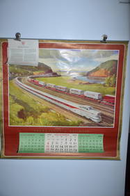
1954 Pennsylvania Railroad Calendar-Pittsburgh Promotes ProgressJM Hobby Supply and Railroad Artifact Auctions4.4(127)See Sold PriceFeb 24, 2024
1956 Pennsylvania Railroad Calendar-Dynamic ProgressJM Hobby Supply and Railroad Artifact Auctions4.4(127)See Sold PriceFeb 24, 2024
BOUTILLON FRENCH DOUBLE CYLINDER VISIBLE GAS PUMP W/ CLOCK FACE.Dan Morphy Auctions4.2(1.3k)See Sold PriceFeb 24, 2024
ERIE MODEL #258 DOUBLE GAS PUMP W/ AMERICAN GAS GLOBE.Dan Morphy Auctions4.2(1.3k)See Sold PriceFeb 24, 2024
GULF SERVICE STATION EMBOSSED PLASTIC LIGHT UP SIGN W/ METAL BODY.Dan Morphy Auctions4.2(1.3k)See Sold PriceFeb 25, 2024
COLLECTION OF 2: GULFPRIDE MOTOR OIL ONE GALLON CANS.Dan Morphy Auctions4.2(1.3k)See Sold PriceFeb 25, 2024
COLLECTION OF 3: GULFPRIDE MOTOR OIL SQUARE QUART CANS.Dan Morphy Auctions4.2(1.3k)See Sold PriceFeb 25, 2024
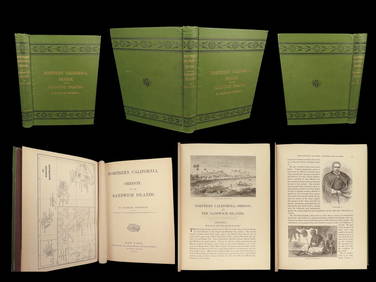
1874 HAWAII 1ed Northern California Oregon Pacific Island Travel Puget RedwoodsSchilb Antiquarian Rare Books4.8(428)See Sold PriceMar 10, 2024
BOTH TITLE PAGES OF COLLINS" COASTAL SURVEY, 1776, IN MATCHING FRAMESThomaston Place Auction Galleries4.4(393)See Sold PriceFeb 24, 2024
VERACRUZ CULTURE, GULF COAST MEXICO, C. 550-950 AD, FLUTEThomaston Place Auction Galleries4.4(393)See Sold PriceFeb 24, 2024
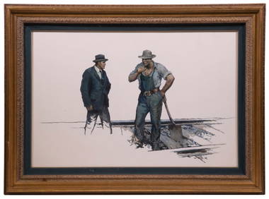
WILLIAM HENRY DETHLEF KOERNER (NJ/NY/MT, 1878-1938)Thomaston Place Auction Galleries4.4(393)See Sold PriceFeb 25, 2024
Parker Vacuum Filler Demonstrator Fountain PenNorth American Pen Auctions LTD4.4(12)See Sold PriceFeb 24, 2024
Henry Lawrence Faulkner Winged Angel Saint Icon Gilt Oil Kentucky Key West NY Gay LGBTQ InterestHess Fine Auctions4.5(210)See Sold PriceMar 02, 2024
Group of Railroad Lapel Pins and Button - West Point Route, Texas & Pacific, Atlantic Coast Line,Rail & Road Auctions4.6(165)See Sold PriceMar 07, 2024
New and Correct Map of North America With the West India Islands,Jasper524.5(9.9k)See Sold PriceFeb 27, 2024
![... Sketch I Showing the Progress of the Survey in Section No.Ix [Gulf Coast of Texas] First Image](https://p1.liveauctioneers.com/5584/289753/153468791_1_x.jpg?height=282&quality=95&version=1684878062&width=282)

![... Sketch I Showing the Progress of the Survey in Section No.Ix [Gulf Coast of Texas] First Image](https://p1.liveauctioneers.com/5584/289753/153468791_1_x.jpg?height=282&quality=1&version=1684878062&width=282)


![... Sketch I Showing the Progress of the Survey in Section No.Ix [Gulf Coast of Texas] (1 of 3)](https://p1.liveauctioneers.com/5584/289753/153468791_1_x.jpg?height=282&quality=70&version=1684878062)