ATLAS of ANTIENT GEOGRAPHY by SAMUEL BUTLER 1843John McInnis Auctioneers,LLC4.5(505)See Sold PriceFeb 24, 2024
18TH C. ANTIQUE MAP: FRENCH & INDIAN WAR, FRAMEDThomaston Place Auction Galleries4.4(393)See Sold PriceFeb 24, 2024
Rand McNally Railroad Map Cabinet w/ 21 Railroad MapsRail & Road Auctions4.6(165)See Sold PriceMar 08, 2024
Keith Haring - Ink on New York Map, Best Buddies, Inscribed, Signed, and DatedSapphire Auction Gallery4.1(67)See Sold PriceMar 02, 2024
LATE 17TH C. FRENCH MAP OF THE NEW WORLD BY ALEXIS-HUBERT JAILLOT (1632-1712)Thomaston Place Auction Galleries4.4(393)See Sold PriceFeb 24, 2024
Central Railroad of New Jersey Map of Sandy Hook Route-ca. 1903JM Hobby Supply and Railroad Artifact Auctions4.4(127)See Sold PriceFeb 24, 2024
Lot of Six Mixed Atlas Box Cars-HO Scale-New in BoxJM Hobby Supply and Railroad Artifact Auctions4.4(127)See Sold PriceFeb 25, 2024
Rand McNally/Santa Fe Railroad Map of Iowa-1912JM Hobby Supply and Railroad Artifact Auctions4.4(127)See Sold PriceFeb 24, 2024
NICOLAES VISSCHER (NETHERLANDS, 1618-1709) MAP OF THE NEW WORLDThomaston Place Auction Galleries4.4(393)See Sold PriceFeb 24, 2024
17TH C. WORLD MAP BY NICOLAES VISSCHER (NETHERLANDS, 1618-1709)Thomaston Place Auction Galleries4.4(393)See Sold PriceFeb 24, 2024
Lot of Six Mixed Atlas Cabooses-HO Scale-New in BoxJM Hobby Supply and Railroad Artifact Auctions4.4(127)See Sold PriceFeb 25, 2024
... Sketch E No.2 Showing the Progress of the Survey at N. Edisto River and EntranceTitle: ... Sketch E No.2 Showing the Progress of the Survey at N. Edisto River and Entrance Date: 1850 Cartographer: U.S. COAST SURVEY Publisher: U.S. COAST SURVEY Description: Triangulation. Shore poSee Sold Price
USCGS: Antique Survey Map of New England, 1889United States Coast and Geodetic survey sketch showing the progress of the survey in sections 1&2 Inset maps of St. Croix River and N.E. Boundary; sketch showing the progress of the survey in SectionSee Sold Price
Sketch E Showing the Progress of the Survey in SectionTitle/Content of Map: Sketch E Showing the Progress of the Survey in Section No. V ... 1866 Date Printed: 1869 Cartographer: U.S. COAST SURVEY Size: 15X20 Details triangulation, coastline, towns, poinSee Sold Price
Sketch E. Showing the Progress of the Survey in SectionTitle: Sketch E. Showing the Progress of the Survey in Section No. V. Publication Date: 1873 Cartographer: BACHE, A.D. Publisher: U.S. COAST SURVEY Size: 21.3 X 36 Additional Information: Detailing thSee Sold Price
Sketch E Showing the Progress of the Survey of SectionTitle: Sketch E Showing the Progress of the Survey of Section V from 1847 to 1853 Cartographer:ANONYMOUS Publisher: U.S. COAST SURVEY Height: 8.6 Width: 32.1 Very browned. Very detailed shore topograpSee Sold Price
Sketch E. No.3 Showing the Progress of the Survey atTitle/Content of Map: Sketch E. No.3 Showing the Progress of the Survey at Savannah Georgia 1850 Cartographer: U.S. COAST SURVEY Date: 1850 Publisher: U.S. C. S. Size: 7Height - 5.5Width TriangulationSee Sold Price
Sketch F No.2 Showing the Progress of the Survey of TheTitle/Content of Map: Sketch F No.2 Showing the Progress of the Survey of The Florida Reefs 1849 - 1855 Cartographer: U.S. Coast Survey Date: 1855 Publisher: U.S. Coast Survey/A.O.P. Nicholson Size: 1See Sold Price
Sketch F No.2 Showing the Progress of the Survey of TheTitle: Sketch F No.2 Showing the Progress of the Survey of The Florida Reefs 1849-1855 Publication Date: 1855 Cartographer: U.S. COAST SURVEY Publisher: U.S.C.S. Size: 17.75 x 14.25 Eight small sheetsSee Sold Price
...Sketch F No.2 Showing the Progress of the Survey ofPublication Date: 1851 Title: ...Sketch F No.2 Showing the Progress of the Survey of Cedar Keys, Bahia Honda, Key Biscayne, Key West and Dry Tortugas in Section No. VI 1849-51 Cartographer: U.S. COASTSee Sold Price
SoldU.S. COAST SURVEY PRINTED MAPSU.S. COAST SURVEY PRINTED MAPS, H 7"-9 1/2" W 7 1/2"-16":Including map of Sketch E. No. 2, "Showing the Progress of the Survey in the Vicinity of Savannah, Georgia, 1850-1852", measuring H. 8 1/2" x 8See Sold Price
U.S. COAST SURVEY PRINTED MAPSU.S. COAST SURVEY PRINTED MAPS, H 7"-9 1/2" W 7 1/2"-16":Including map of Sketch E. No. 2, "Showing the Progress of the Survey in the Vicinity of Savannah, Georgia, 1850-1852", measuring H. 8 1/2" x 8See Sold Price
Sketch E Showing the Progress of Section No.V ... 1847Title: Sketch E Showing the Progress of Section No.V ... 1847 to 1860 Cartographer: U.S. Coast Survey Publisher: GPO Size: 22 X 35.5 Bull's Island to Savannah River, South Carolina and Georgia coast,See Sold Price
(E No.7) Preliminary Sketch of North Edisto RiverPublication Date: 1851 Title: (E No.7) Preliminary Sketch of North Edisto River Cartographer: WISE, G. D. Publisher: U.S. COAST SURVEY Height: 17 Width: 13.75 "from a trigonometrical survey ... TriangSee Sold Price
SoldU S Coast Survey 1896 Large Map. Portland Canal, Alaska"Progress Sketch Showing Triangulation of Portland Canal and Vicinity. S. E. Alaska" Large Lithograph Map Published 1896, Washington for "U.S. Coast and Geodetic Survey" Folds as issued. Rare. Paper SSee Sold Price
U S Coast Survey 1896 Large Map. Portland Canal, Alaska"Progress Sketch Showing Triangulation of Portland Canal and Vicinity. S. E. Alaska" Large Lithograph Map Published 1896, Washington for "U.S. Coast and Geodetic Survey" Folds as issued. Rare. Paper SSee Sold Price
U S Coast Survey 1896 Large Map. Portland Canal, Alaska"Progress Sketch Showing Triangulation of Portland Canal and Vicinity. S. E. Alaska" Large Lithograph Map Published 1896, Washington for "U.S. Coast and Geodetic Survey" Folds as issued. Rare. Paper SSee Sold Price
U S Coast Survey 1896 Large Map. Portland Canal, Alaska"Progress Sketch Showing Triangulation of Portland Canal and Vicinity. S. E. Alaska" Large Lithograph Map Published 1896, Washington for "U.S. Coast and Geodetic Survey" Folds as issued. Rare. Paper SSee Sold Price
U S Coast Survey 1896 Large Map. Portland Canal, Alaska"Progress Sketch Showing Triangulation of Portland Canal and Vicinity. S. E. Alaska" Large Lithograph Map Published 1896, Washington for "U.S. Coast and Geodetic Survey" Folds as issued. Rare. Paper SSee Sold Price
U S Coast Survey 1896 Large Map. Portland Canal, Alaska"Progress Sketch Showing Triangulation of Portland Canal and Vicinity. S. E. Alaska" Large Lithograph Map Published 1896, Washington for "U.S. Coast and Geodetic Survey" Folds as issued. Rare. Paper SSee Sold Price
SoldAntique Carved White Jade Panel Table ScreenChina, delicately open carved wooden screen with a large piece of white jade panel Expertly carved depicting two figures of sages standing within a wooded area showing river, blossoms trees, rockwork,See Sold Price
SoldNavajo Sterling Turquoise Squash Blossom N & ENecklace & Earrings by Leonara Garcia 22" w 2 1/2" drop 1" earringsSee Sold Price
SoldAntique Civil War Artillery Shell USS Columbine FLAntique Civil War USS Columbine St Johns River Florida Artillery Shell. Reads US Wt 20 lbs Found St. Johns River N. Fla off the USS Columbine 275-143. Shipping cost is not included. Measures 9.5 incheSee Sold Price
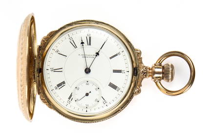
SoldHamilton Watch Co. 17 jewels pocket watchEngraved to E L Messinger by N E Merkle 1913, (working)See Sold Price
SoldE. Whitney RevolverMarked E. Whitney, N. Haven on top of the octagonal barrel. Pre-1862 with walnut grips. 4" barrel.See Sold Price
OUTSTANDING MOBIL PEGASUS PORCELAIN COOKIE CUTTER SIGN.Dan Morphy Auctions4.2(1.3k)See Sold PriceFeb 24, 2024
JOHN WARD OF HULL (United Kingdom, 1798-1849), "A Frigate Offshore"., Oil on canvas, 19.5" x 28".Eldred's4.7(419)See Sold PriceFeb 28, 2024
ANTONIO NICOLO GASPARO JACOBSEN (New York/New Jersey/Denmark, 1850-1921), The screw steamer PieterEldred's4.7(419)See Sold PriceFeb 27, 2024
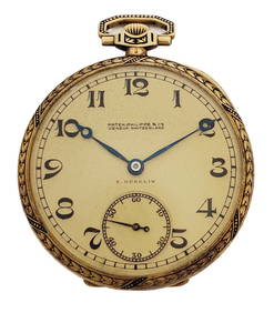
18k Gold Patek Philippe E Gubelin Black Enamel Art Deco Mens Pocket WatchHess Fine Auctions4.5(210)See Sold PriceMar 02, 2024
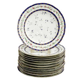
12 Sevres Hand Painted Porcelain Dessert Plates in Directoire Buteux DuroseyTaylor & Harris4.7(161)See Sold PriceMar 10, 2024
Robert Delaunay (French, 1885–1941) - Portrait de Madame Jacques HeimFreeman's | Hindman4.5(158)See Sold PriceFeb 27, 2024
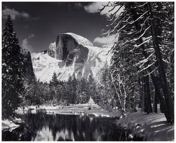
Ansel Adams (1902-1984), "Half Dome, Merced River, Winter," 1938, Gelatin silver print on paperJohn Moran Auctioneers, Inc.4.7(461)See Sold PriceFeb 27, 2024
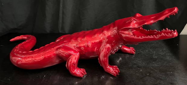
RED CROCODILE signed RICHARD ORLINSKI ( Born1966) Born WildBasel Auction House4.5(47)See Sold PriceFeb 24, 2024
375+ 1960s Estate Fresh Non-Sports Card CollectionBruneau & Co. Auctioneers4.5(491)See Sold PriceFeb 24, 2024
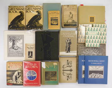
17 Books illustrated by Rockwell Kent (1881-1972)Rachel Davis Fine Arts4.7(477)See Sold PriceMar 02, 2024