ATLAS of ANTIENT GEOGRAPHY by SAMUEL BUTLER 1843John McInnis Auctioneers,LLC4.6(504)See Sold PriceFeb 24, 2024
18TH C. ANTIQUE MAP: FRENCH & INDIAN WAR, FRAMEDThomaston Place Auction Galleries4.4(389)See Sold PriceFeb 24, 2024
Rand McNally Railroad Map Cabinet w/ 21 Railroad MapsRail & Road Auctions4.6(165)See Sold PriceMar 08, 2024
Keith Haring - Ink on New York Map, Best Buddies, Inscribed, Signed, and DatedSapphire Auction Gallery4.1(67)See Sold PriceMar 02, 2024
LATE 17TH C. FRENCH MAP OF THE NEW WORLD BY ALEXIS-HUBERT JAILLOT (1632-1712)Thomaston Place Auction Galleries4.4(389)See Sold PriceFeb 24, 2024
Central Railroad of New Jersey Map of Sandy Hook Route-ca. 1903JM Hobby Supply and Railroad Artifact Auctions4.4(126)See Sold PriceFeb 24, 2024
Lot of Six Mixed Atlas Box Cars-HO Scale-New in BoxJM Hobby Supply and Railroad Artifact Auctions4.4(126)See Sold PriceFeb 25, 2024
Rand McNally/Santa Fe Railroad Map of Iowa-1912JM Hobby Supply and Railroad Artifact Auctions4.4(126)See Sold PriceFeb 24, 2024
NICOLAES VISSCHER (NETHERLANDS, 1618-1709) MAP OF THE NEW WORLDThomaston Place Auction Galleries4.4(389)See Sold PriceFeb 24, 2024
17TH C. WORLD MAP BY NICOLAES VISSCHER (NETHERLANDS, 1618-1709)Thomaston Place Auction Galleries4.4(389)See Sold PriceFeb 24, 2024
Lot of Six Mixed Atlas Cabooses-HO Scale-New in BoxJM Hobby Supply and Railroad Artifact Auctions4.4(126)See Sold PriceFeb 25, 2024
Sold"MAP OF THE BERMUDAS OR SOMERS ISLANDS" 20th Century"MAP OF THE BERMUDAS OR SOMERS ISLANDS"20th CenturyColorful depiction of Bermuda with surrounding decoration of nautical, military and industry themes.17.5" x 23" sight. Framed 24.See Sold Price
Framed Ink Hand-drawn Salt Spring Island Area MapFramed Ink Hand-drawn Salt Spring Island Area Map, 20th century, sight lg. 19 in.See Sold Price
SoldFramed Ink Hand-drawn Salt Spring Island Area MapFramed Ink Hand-drawn Salt Spring Island Area Map, 20th century, sight lg. 19 in.See Sold Price
Framed Ink Hand-drawn Salt Spring Island Area Map,Framed Ink Hand-drawn Salt Spring Island Area Map, 20th century, sight lg. 19 in.See Sold Price
SoldEarly 20th century Long Island bridle paths map, ''MapEarly 20th century Long Island bridle paths map, ''Map showing approximate location & general direction of bridle paths maintained by the county lanes committee, Oyster Bay - East Norwich, Glen Cove -See Sold Price
SoldHAND-COLORED MAP OF CAPE COD AND THE ISLANDS Early 20thHAND-COLORED MAP OF CAPE COD AND THE ISLANDS Early 20th Century 16.5" x 26.5" sight. Framed 23" x 33".See Sold Price
SoldMaps, Oahu Hawaiian Islands(lot of 3) Hawaiian School (20th century), "Oahu Hawaiian Islands," copper-engraved map with hand-painting, reproduced in 1984, "General Map of the Island of Maui" copper-engraved map with hand-paintiSee Sold Price
SoldLarge German Map of Australia and the Polynesian IslLarge German Map of Australia and the Polynesian Islands, Holzel, early 20th century, with one wooden roller.See Sold Price
SoldJohn Cobb Narragansett Bay Rhode Island MapMassachusetts,20th Century Aerial view map with scenic landscape decoration of Narragansett Bay. Frame 19" x 22 1/2", From the collection of a North Scituate, Rhode Island gentleman.See Sold Price
Sold20th Century Framed Map of Nantucket IslandFramed map of Nantucket Island. Map highlights include Sandy Point, Sankaty Head, Brant Point and Tuckanuck Island. Mounted into an ornate black Frame. 48 X 37. Condition: very good. 20th Century.See Sold Price
Lefroy Bermudas or Somers Islands 1515-1685Lefroy (J.H.) Memorials of the Discovery and Early Settlement of the Bermudas or Somers Islands 1515-1685,2 vol., first edition, half-titles, wood-engraved frontispiece, 3 maps (2 folding), anSee Sold Price
SoldBERMUDA HISTORY / ARCHAEOLOGY VOLUMES, SET OF TWOBERMUDA HISTORY / ARCHAEOLOGY VOLUMES, SET OF TWO, J.H. Lefroy, "Memorials of the Discovery and Early Settlement of the Bermudas or Somers Islands", 1981, the Bermuda Historical Society, printed by thSee Sold Price
Map of "Tonga Islands, Vavau Group", hand painted onMap of "Tonga Islands, Vavau Group", hand painted on tapa cloth. 19th/20th Century. 58 x 47cmSee Sold Price
SoldTwo Maps of Long Island20th century. Larger overall size 19.5 x 37 inches. Notice to bidders: Condition reports and additional photographs are provided by request as a courtesy to our clients, as such any condition report iSee Sold Price
Sold~19 maps, [mid-1800s to ca. 1900].[Bermuda/19th-20th Century Maps]. Approx. 19 Items (about 18 maps & 1 illustration). Size varies. Mostly very good to fine. Sold with all faults. ++ The Bermudas. (Pocket map; front cover title: Map oSee Sold Price
SoldVintage Hand Painted Nantucket Lamp ShadeScarce Vintage Hand Painted Nantucket Lamp Shade, decorated with map of the island, ships, and whales Height 7 in. Diameter 10 in. Dimensions Height 7 in. Diameter 10 in. Origin <See Sold Price
SoldGrenfell Mat - Map of LabradorEarly 20th century. Hooked mat with brown border around a map of Labrador Island in shades of pink, white, and blue. Embellished with stylized images of wildlife, boats, the wind, and coastal villagesSee Sold Price
Yizhak Elyashiv(Rhode Island/Israel, 20th/21st century) A Handful of Grains Map #3, circa 1997-98, ink, non-pigment ink drypoint etching on paper in 10 sheets, 6 x 10 ft.; wood frame. Condition: good condition; plexSee Sold Price
Map of New EnglandNational Publishing Co. (Early 20th Century).The National Publishing Company's Railroad Post Office, Township and County Map of Massachusetts, Rhode Island and Connecticut, 1901.Lithographed map withSee Sold Price
SoldJapanese Arita Ware Blue and White Map Tray20th century, porcelain tray or dish, rectangular form with scalloped rim, molded in relief with blue glazed map of Japan and surrounding islands, four character mark on underside, 11-3/4 x 12 in. - PSee Sold Price
An Arts & Crafts leaded glass hanging lamp20th century, marked ''Somers Stained Glass, 77 Long Island, NY'', of mushroom form, with scalloped mottled ivory slag glass panels interspersed with black swags, with a border of roses and poppies inSee Sold Price
SoldJain Painting, A Cosmological Map of Jambudvida,Opaque watercolors with ink on cloth India, 19th/20th century Depiction of the island continent Jambudvipa with Mount Meru at its center Depiction as concentric circles and rings in the dominant colorSee Sold Price
SoldFW Falls Long Island NY Yard Long ChromolithographUNITED STATES, EARLY 20TH CENTURY A yard long chromolithograph of Long Island, New York after F.W Falls. The map illustrates the topography of Long Island, Manhattan, and Montauk giving a representatiSee Sold Price
Sold(DOUGLASS, FREDERICK.) Report of the Commission of(DOUGLASS, FREDERICK.) Report of the Commission of Inquiry to the Island of Santo Domingo. Folding map. 297 pages. 8vo, 20th-century ¼ calf, minimal wear; first 18 leaves repaired on inner margins anSee Sold Price
Providence School: Stacy Tolman landscape (Attic Sale)Bert Gallery Studio Sales4.4(18)See Sold PriceFeb 27, 2024
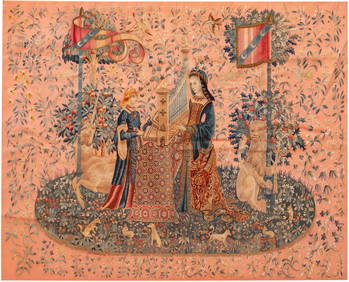
No Reserve Early 20th century French / Flemish Design Tapestry 6 ft 2 in x 4 ft 9 in (1.87 m x 1.44Nazmiyal Auctions4.4(34)See Sold PriceFeb 25, 2024
No Reserve Early 20th Century Antique French Colonnades Tapestry 7 ft 2 in x 4 ft 11 in (2.18 m xNazmiyal Auctions4.4(34)See Sold PriceFeb 25, 2024
No Reserve Early 20th Century French Unicorn Design Tapestry 5 ft 9 in x 4 ft 8 in (1.75 m x 1.42 m)Nazmiyal Auctions4.4(34)See Sold PriceFeb 25, 2024
Early 1900's Railway Service Map, Illinois, Ohio, Indiana, Kentucky, TennesseeConnoisseur Auctions3.9(335)See Sold PriceFeb 24, 2024
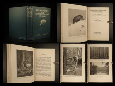
1912 HUNTING Alaska Vancouver Sheldon Wilderness of North Pacific Canada BearSchilb Antiquarian Rare Books4.8(422)See Sold PriceMar 31, 2024
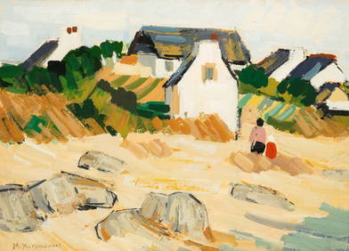
MABEL MAY WOODWARD (1877-1945) "BEACH LANDSCAPE".Amelia Jeffers, Auctioneers & Appraisers4.5(116)See Sold PriceMar 07, 2024
1750 Bowen Map of Bermuda and St. Kitts -- A New & Accurate Map of Bermudas or Sommer's Islands...Jasper524.5(9.8k)See Sold PriceFeb 27, 2024
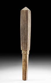
Early 20th C. Polynesian Fijian Coconut Cups (pr)Artemis Fine Arts4.8(1.4k)See Sold PriceFeb 26, 2024
Joan Grober (AMERICAN / RHODE ISLAND, 20th Century) watercolor work on artist paper depicting aJoshua Kodner4.2(387)See Sold PriceMar 09, 2024


![~19 maps, [mid-1800s to ca. 1900]. (1 of 5)](https://p1.liveauctioneers.com/179/47316/21802671_1_x.jpg?height=282&quality=70&version=1383851649)