1952 ROBERT F. KENNEDY HANDWRITTEN LETTERJohn McInnis Auctioneers,LLC4.5(505)See Sold PriceFeb 25, 2024
CASED PRESENTATION HALF HULL MODEL OF THE BARQUE "HAWTHORNBANK" Last Quarter of the 19th CenturyEldred's4.7(419)See Sold PriceFeb 27, 2024
Lot Of 14 Jack Daniels And Country Club Glass Spirit BottlesRbfinearts4.5(578)See Sold PriceFeb 24, 2024
PR OF 17TH C. SPANISH BRASS CANDLESTICKSThomaston Place Auction Galleries4.4(393)See Sold PriceFeb 24, 2024
Lake Shore and Michigan Southern RR Special Excursions Timetable-July 7-13, 1892JM Hobby Supply and Railroad Artifact Auctions4.4(127)See Sold PriceFeb 24, 2024
Tiffany & Co. Sterling Silver Corkscrew Bottle OpenerSJ Auctioneers4.5(167)See Sold PriceMar 03, 2024
SoldReport on California with maps 1850Heading: (California & New Mexico) Author: [Taylor, Zachary] Title: California and New Mexico: Message of the President of the United States, Transmitting information... on the Subject of California aSee Sold Price
SoldReport on California with maps 1850Heading: (California & New Mexico) Author: [Taylor, Zachary] Title: California and New Mexico: Message of the President of the United States, Transmitting information... on the Subject of California aSee Sold Price
SoldReport on California with maps 1850Heading: (California & New Mexico) Author: [Taylor, Zachary] Title: California and New Mexico: Message of the President of the United States, Transmitting information... on the Subject of California aSee Sold Price
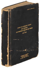
SoldTyson Report with gold region maps 1850Heading: Author: Tyson, P[hilip] T. Title: Report of the Secretary of War, communicating information in relation to the geology and topography of California Place Published: [Washington] Publisher:See Sold Price
Charge At Buena Vista CaliforniaEarly View Near Monterey California Mexican American War Artist: Lt. A. Sully Print Type: Engraving Date: Circa 1850 Demensions:See Sold Price
Charge At Buena Vista CaliforniaEarly View Near Monterey California Mexican American War Artist: Lt. A. Sully Print Type: Engraving Date: Circa 1850 Demensions:See Sold Price
Charge At Buena Vista CaliforniaEarly View Near Monterey California Mexican American War Artist: Lt. A. Sully Print Type: Engraving Date: Circa 1850 Demensions:See Sold Price
Sold1850 California Convention Report State Constitution1850 California Convention Report State Constitution GOLD Rush Slavery MEXICO An interesting record of the formation of the state of California in its constitution and historical law. The "ConstitutioSee Sold Price
1850 map of California and Territories by CowperthwaitVery desirable and distinctive map of the American west, with Utah Territory and New Mexico Territory accounting for nearly half of the West. “A New Map of the State of California, the Territories oSee Sold Price
SoldLake Superior Maps, Foster & Whitney's Report[Michigan/Lake Superior Maps] 2 Items incl. maps showing Lake Superior, Michigan, from Foster & Whitney's Report, c. 1850. Map volume from: John Wells Foster and Josiah D. Whitney. [REPORT ON THE GEOLSee Sold Price
1858 Map of Public Surveys in California...This remarkable large format map of California reports the extent of the Land Office Survey through 1858, just eight years after it had become the 31st state in the Union. The map is highly detailed wSee Sold Price
SoldCalifornia Gold Rush, San Francisco, maritime,Heading: (California Gold Rush - map-making, 1850) Author: Title: Future official surveyor of Alcatraz and San Francisco sails for California, 1850 letter Place Published: Publisher: Date PublSee Sold Price
Sold1850 Cowperthwait Map of California, Oregon, Utah andTitle/Content of Map: 1850 Cowperthwait Map of California, Oregon, Utah and New Mexico Terr. -- A New Map of the State of California, The Territories of Oregon & Utah and the Chief Part of New MexicoSee Sold Price
Jones' Report on California Land Titles with MapHeading: (California - San Francisco) Author: Jones, William Carey Title: Report of the Secretary of the Interior, Communicating a Copy of the Report of William Carey Jones, Special Agent to Examine tSee Sold Price
SoldJones' Report on California Land Titles with MapTitle: Report of the Secretary of the Interior, Communicating a Copy of the Report of William Carey Jones, Special Agent to Examine the Subject of Land Titles in California Author: Jones, William CareSee Sold Price
SoldJones' Report on California Land Titles with MapHeading: (California - San Francisco) Author: Jones, William Carey Title: Report of the Secretary of the Interior, Communicating a Copy of the Report of William Carey Jones, Special Agent to Examine tSee Sold Price
Jones' Report on California Land Titles with MapHeading: (California - San Francisco) Author: Jones, William Carey Title: Report of the Secretary of the Interior, Communicating a Copy of the Report of William Carey Jones, Special Agent to Examine tSee Sold Price
Sold1850 Tallis map of Mexico California During Gold RushReserve Reduced! Title/Content of Map: 1850 Tallis map of Mexico California During Gold Rush and Texas -- Mexico, California and Texas Date: 1850, London Cartographer: J Tallis Size: 10 X 13 in. ThisSee Sold Price
SoldCopper Engraved Map of California, c. 1850Copper Engraved Map of California, "Reconnaissance of the Tulares Valley," c. 1850, made by order of Brev. Brig. Gen. Riley, commanding 10th. Mil. Dept., engraved by Lt. George Horatio Derby, from theSee Sold Price
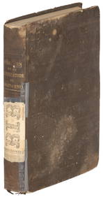
Sold1850 1ed California & New Mexico Congress Reports GOLD1850 1ed California & New Mexico Congress Reports GOLD Alta Mexico US President ‘California and New Mexico’ is a highly important mid-19th-century report on the development of the American west duSee Sold Price
SoldPreuss/Fremont map of Upper California 1850Heading: Author: Preuss, Charles Title: Map of Oregon and Upper California from the Surveys of John Charles Frémont and other Authorities, Drawn by Charles Preuss Under the Order of the Senate of thSee Sold Price
SoldPreuss/Fremont map of Upper California 1850Title: Map of Oregon and Upper California from the Surveys of John Charles Frémont and other Authorities, Drawn by Charles Preuss Under the Order of the Senate of the United States, Washington City,See Sold Price
SoldRare map of California Gold Region 1850Heading: Author: Ellis, Robert H. Title: Map of the Gold Region of California taken from a recent survey By Robert H. Ellis 1850 Place Published: New York Publisher:George F. Nesbitt Lith Date PSee Sold Price
SoldPreuss/Fremont map of Upper California 1850Title: Map of Oregon and Upper California from the Surveys of John Charles Frémont and other Authorities, Drawn by Charles Preuss Under the Order of the Senate of the United States, Washington City,See Sold Price
Ohio and Pennsylvania RR 2nd Annual Report-March 4, 1850JM Hobby Supply and Railroad Artifact Auctions4.4(127)See Sold PriceFeb 24, 2024
Ohio and Pennsylvania RR 2nd Annual Report-1850JM Hobby Supply and Railroad Artifact Auctions4.4(127)See Sold PriceFeb 24, 2024
An "Official Disneyland Road Map" Richfield Brochure.Van Eaton Galleries4.6(99)See Sold PriceMar 02, 2024
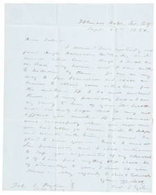
1850 California gold rush letter from Fred Snyder to brotherPBA Galleries4.7(385)See Sold PriceMar 07, 2024
Carte de L'Algérie et de la Régence de Tunis' ANDRIVEAU-GOUJON Algeria 1850 mapJasper524.5(9.9k)See Sold PriceFeb 28, 2024
California Vintage Maps & Brochures (44 Pcs)Grant Zahajko Auctions, LLC4.7(1k)See Sold PriceMar 06, 2024