Vintage Ca. 1940's International Panel Delivery Truck Converted into Stationary Food Truck, WasSwisher Bros. Auction LLC4.4(251)See Sold PriceFeb 25, 2024
Thomas Hart Benton; 20thC. American Regionalist Oil SignedMid-Hudson Auction Galleries4.4(470)See Sold PriceFeb 24, 2024
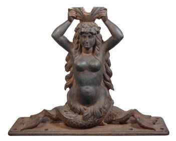
CAST IRON SHIP'S WHEEL BRACKET HELM IN THE FORM OF A MERMAID Last Quarter of the 19th/First QuarterEldred's4.7(418)See Sold PriceFeb 27, 2024
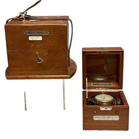
Hamilton Chronometer Model 22 Ship Clock 8630Premier Auction Galleries4.3(329)See Sold PriceMar 09, 2024
Art Deco Collectible Uranium Glass VICTOIRE Car Mascot Hood Ornament 1930' H.Hoffmann SculptureArt Glass Store4.5(61)See Sold PriceMar 03, 2024
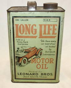
Graphic Long Life 1 Gallon Motor Oil CanCheck the Oil Promotions, LLC4.6(305)See Sold PriceMar 03, 2024
Art Deco 1930' Collectible Glass Car Mascot ' Spirit Of The Wind ' H.Hoffmann by LaliqueArt Glass Store4.5(61)See Sold PriceMar 03, 2024
ATLAS of ANTIENT GEOGRAPHY by SAMUEL BUTLER 1843John McInnis Auctioneers,LLC4.6(504)See Sold PriceFeb 24, 2024
18TH C. ANTIQUE MAP: FRENCH & INDIAN WAR, FRAMEDThomaston Place Auction Galleries4.4(389)See Sold PriceFeb 24, 2024
Rand McNally Railroad Map Cabinet w/ 21 Railroad MapsRail & Road Auctions4.6(165)See Sold PriceMar 08, 2024
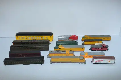
Huge Tote of HO Scale Steam and Diesel Train Locomotives, Cars and PartsJM Hobby Supply and Railroad Artifact Auctions4.4(126)See Sold PriceFeb 25, 2024
MAP, Western Africa, BlaeuWestern Africa. Willem Blaeu, Guinea, from Theatre du Monde ou Nouvel Atlas, 1643 (circa). Hand Color. Elegantly engraved map covering the coast from Sierra Leone to Gabon. The land is filled with aniSee Sold Price
MAP, Western Africa, BlaeuWestern Africa. Willem Blaeu, Guinea, from Theatre du Monde ou Nouvel Atlas, 1643 (circa). Hand Color. Elegantly engraved map covering the coast from Sierra Leone to Gabon. The land is filled with aniSee Sold Price
Decorative Map of Africa by BlaeuNigritarum Regio. Johannes Blaeu (1596-1673). Engraved map with original hand color in outline. Amsterdam: J. Blaeu, c. 1650. 20 1/2 x 23 1/2 inches sheet. Decorative map of the western part of AfricaSee Sold Price
SoldTallis, John (Pub) 1852 Map. Western AfricaSteel Engraved Map with Original Outline Hand Color Published 1852-56 by John Tallis, London for "The Universal Pronouncing Dictionary" by Thomas Wright. Drawn & Engraved by John Rapkin. Centre fold aSee Sold Price
MAP, Western Africa, BasireWestern Africa. Isaac Basire, A Pholey Town & Plantations About It, from Moore, 1745 (circa). Black & White. This interesting engraving presents a walled village of the Fula people of the Senegambia rSee Sold Price
MAP, Western Africa, KeulenWestern Africa. Johannes van Keulen, Nieuwe Paskaert, van de Kust van Genehoa als Mede een Gedeelte van Gambia, Beginnende an C. Blanco tot C. Verde..., 1681 (circa). Hand Color. This attractive sea cSee Sold Price
MAP, Western Africa, De WitWestern Africa. Frederick de Wit, Guinea, 1680 (circa). Hand Color. Elegantly engraved map covering the coast from Sierra Leone to Gabon. The land is filled with elephants, lions, leopards and monkeysSee Sold Price
MAP - Western Africa. CoronelliWestern Africa. Vicenzo Maria Coronelli, Isole della Guinea [on verso] Isola Goree, 1696 (circa). Hand Color. This charming map of Western Africa contains spurious information and lovely decorative elSee Sold Price
MAP, Western Africa, SansonWestern Africa. Nicolas Sanson, L'Afrique, ou Lybie Ulterieure ou sont le Saara, ou Desert, le Pays des Negres, la Guinee, et les Pays Circonu..., from Cartes Generales de Toutes les Parties du Monde�See Sold Price
MAP, Western Africa, CoronelliWestern Africa. Vincenzo Maria Coronelli, Isole della Guinea [on verso] Isola Goree, 1696 (circa). Black & White. This charming map of Western Africa contains spurious information and lovely decorativSee Sold Price
MAP, Western Africa, SansonWestern Africa. Nicolas Sanson, La Guinee et Pays Circomvoisins; Tires de Mercator de Blommart &c., 1683 (circa). Hand Color. This attractive copper engraved map of the Guinea coast includes Guinea, BSee Sold Price
MAP, Western Africa, SansonWestern Africa. Nicolas Sanson, L'Afrique, ou Lybie Ulterieure ou sont le Saara, ou Desert, le Pays des Negres, la Guinee, et les Pays Circonu..., 1655 (dated). Hand Color. Handsome map of Western AfrSee Sold Price
MAP, Western Africa, LangenesWestern Africa. Barent Langenes, Guinea, 1602 (circa). Hand Color. A beautiful miniature map of the west coast of Africa covering the coast from Liberia to Cameroon. The majority of the place names arSee Sold Price
MAP, Western Africa, SansonWestern Africa, Cape Verde Islands. Nicolas Sanson, Isles du Cap Verd Coste, et Pays des Negres aux Environs du Cap Verd..., from Geographise en Historise Werelt Beschryving, 1683 (published). Hand CoSee Sold Price
MAP, Western Africa, Van der AaWestern Africa. Pieter van der Aa, Guinee, Grand Pays de l'Afrique, avec Toutes ses Cotes, Havres et Rivieres, Suivant les Memoires les Plus Recens des Voyageurs..., 1729 (circa). Hand Color. This hanSee Sold Price
MAP, Western Africa, ChatelainWestern Africa. Henry Abraham Chatelain, Vue & Description de la Ville de Lovango dans le Royaume de Congo avec Plusieurs Particularitez Curieuses Touchant les Moeurs & les Habillemens des Indiens duSee Sold Price
MAPS, Western Africa, Robert de VaugondyWestern Africa. Didier Robert de Vaugondy, [Lot of 2] Partie Occidentale de la Nigritie et de la Haute Guinee [and] Partie Orientale de la Haute Guinee, from Atlas Portatif Universel et Militaire, 174See Sold Price
MAPS, Western Africa, BellinWestern Africa. Jacques Nicolas Bellin, [Lot of 3] Partie de la Coste de Guinee Depuis la Riviere de Sierra Leona... [and] Suite de la Coste de Guinee Depuis le Cap de Palme... [and] Suite de la CosteSee Sold Price
MAPS, Western Africa, MortierWestern Africa. Pierre Mortier, [Lot of 3] Carte Particuliere des Costes de l'Afrique qui Comprend le Royaume de Maroc &c... [and] ... Depuis Cabo Corso Jusques a Omorro... [and] ... qui Comprend uneSee Sold Price
WESTERN AFRICA.Kong Mountains.Caravan routes.SlaveTITLE/CONTENT OF MAP: 'Western Africa' The map shows sub-saharan west Africa prior to the later "Scramble for Africa" colonisation. Senegambia is shown, as is the state of Liberia. Ashantee (roughly pSee Sold Price
WESTERN AFRICA.Kong Mountains.Caravan routes.SlaveTITLE/CONTENT OF MAP: 'Western Africa' The map shows sub-saharan west Africa prior to the later "Scramble for Africa" colonisation. Senegambia is shown, as is the state of Liberia. Ashantee (roughly pSee Sold Price
PRE COLONIAL WESTERN AFRICA. Shows Mountains of Kong.TITLE/CONTENT OF MAP: 'Western Africa' The map shows the tribal regions of pre-colonial Africa. Lagos is indicated as having been "ceded to the British August 1861". Marked on this map are the MountaiSee Sold Price
PRE COLONIAL WESTERN AFRICA. Shows Mountains of Kong.TITLE/CONTENT OF MAP: 'Western Africa' The map shows the tribal regions of pre-colonial Africa. Lagos is indicated as having been "ceded to the British August 1861". Marked on this map are the MountaiSee Sold Price
Colton: Antique Map of Western Africa, 1858Title/Content of Map: Western Africa by Colton Date Printed: 1858 Cartographer: H.J. Colton Material/Medium: Paper Size: 17 1/2" x 15" Hand colored engraved. Published in New York 'Colton's General AtSee Sold Price
EARLY COLONIAL WEST AFRICA. Empires of Sokoto Gando Mas.Tribes.Fellatah 1882 mapJasper524.5(9.8k)See Sold PriceFeb 28, 2024
NORTH & WEST AFRICA. Gold Coast (Ghana) Slave Coast. Tribal names 1890 mapJasper524.5(9.8k)See Sold PriceFeb 28, 2024
West coast of Africa from Cape Blanco… Arguin bay, Mauritania. LABAT 1745 mapJasper524.5(9.8k)See Sold PriceFeb 28, 2024
Western Africa by Edward Weller. Early British/French settlements 1860 old mapJasper524.5(9.8k)See Sold PriceFeb 28, 2024
West Africa. Liberia Sahara Senegambia Guinea. Mountains of Kong COLTON 1869 mapJasper524.5(9.8k)See Sold PriceFeb 28, 2024
North west Africa. Liberia inset. Sahara Senegambia Guinea. COLTON 1863 mapJasper524.5(9.8k)See Sold PriceFeb 28, 2024
WESTERN AFRICA.Kong Mountains.Caravan routes.Slave Coast.TALLIS/RAPKIN 1849 mapJasper524.5(9.8k)See Sold PriceFeb 28, 2024
WEST CENTRAL AFRICA. Congo Angola Gabon Cameroon Sao Tome. MALLET 1683 old mapJasper524.5(9.8k)See Sold PriceFeb 28, 2024
Western Sahara. Africa 1885 old antique vintage map plan chartJasper524.5(9.8k)See Sold PriceFeb 28, 2024
Partie Occidentale de l’Afrique. West Africa coast Canary islands BONNE 1788 mapJasper524.5(9.8k)See Sold PriceFeb 28, 2024
Colonial Central Africa. Belgian Congo. French Equatorial Africa. TIMES 1922 mapJasper524.5(9.8k)See Sold PriceFeb 28, 2024
WESTERN AFRICA.Kong Mountains.Caravan routes.Slave Coast.TALLIS/RAPKIN 1851 mapJasper524.5(9.8k)See Sold PriceFeb 28, 2024
Western coast of Africa… to the River Sanaga. Southern Mauritania LABAT 1745 mapJasper524.5(9.8k)See Sold PriceFeb 28, 2024
EARLY COLONIAL WEST AFRICA. Empires of Sokoto Gando Mas.Tribes.Fellatah 1886 mapJasper524.5(9.8k)See Sold PriceFeb 28, 2024
Operation Torch Nov 1942-May 1943. World War 2. Western Mediterranean 1966 mapJasper524.5(9.8k)See Sold PriceFeb 28, 2024
Western Africa by Edward Weller. Early British/French settlements 1859 old mapJasper524.5(9.8k)See Sold PriceFeb 28, 2024
PRE COLONIAL WESTERN AFRICA. Shows Mountains of Kong. Tribes. WELLER 1863 mapJasper524.5(9.8k)See Sold PriceFeb 28, 2024