SoldMAP, Baltic, LotterBaltic. Tobias Conrad Lotter, Borussiae Regnum Complectens Circulos Sambiensem, Natagiensem et Hockerlandiae nec non Borussia Polonica..., 1760 (circa). Hand Color. This is a very beautiful map due toSee Sold Price
SoldFramed Antique Nautical Map Baltic SeaFramed and Matted Antique Nautical Map of the Baltic Sea, not dated but probably earlier than the 1700's. 24" x 20"See Sold Price
Antique Map: Baltic Coast & South Poland. 1584, AntwerpOriginal map of the Baltic Sea Coast from Rugen to Gdansk, the Baltic States of Estonia, Latvia and Lithuania, as well as parts of Poland north of the Carpathian Mountains. Antique map of Prussia, PoSee Sold Price
SoldMAP, Baltic, CluverBaltic. Philipp Cluver, Prussiae Nova Tabula, from Introductio in Universam Geographicam, 1697 (published). Hand Color. This finely engraved map covers northeastern Poland from about Gdansk to LithuanSee Sold Price
Antique Map: Baltic Coast & South Poland. 1584, AntwerpOriginal map of the Baltic Sea Coast from Rugen to Gdansk, the Baltic States of Estonia, Latvia and Lithuania, as well as parts of Poland north of the Carpathian Mountains. Antique map of Prussia, PoSee Sold Price
Antique Map: Baltic Coast & South Poland. 1584, AntwerpDESCRIPTION: Original map of the Baltic Sea coast from Rugen to Gdansk, the Baltic States of Estonia, Latvia and Lithuania, as well as parts of Poland north of the Carpathian Mountains. Antique map oSee Sold Price
2 Maps: Lotter's Bavaria & City of London 18th centLot of two European maps. 1st item: Tobias Conrad Lotter/Johann Franz Kholbrenner, 1764 engraved map of Bavaria. Shows Munchen, Salzburg, etc. Hand colored borders and compass rose. Key to cities at lSee Sold Price
Sold1 piece. Hand-Colored Engraved Map. Lotter, Tobia1 piece. Hand-Colored Engraved Map. Lotter, Tobias Conrad. Pensylvania, Nova Jersey et Nova York..." Augsburg, [ca. 1750]. 22 3/4 x 19 3/4 inches; 580 x 502 mm. Old (orig.?) color. Crease along centerSee Sold Price
Sold1 piece. Hand-Colored Engraved Map. Lotter, Mathi1 piece. Hand-Colored Engraved Map. Lotter, Mathias Albrecht. Carte Nouvelle de l'Amerique Angloise... avec la Florida." Augsburg, [ca. 1770]. 23 5/8 x 19 1/4 inches; 600 x 489 mm. Old (orig.?) color,See Sold Price
Sold1 piece. Hand-Colored Engraved Map. Lotter, T(obi1 piece. Hand-Colored Engraved Map. Lotter, T(obias) C(onrad). Asia." Augsburg, ca. 1760. 19 x 23 inches; 482 x 584 mm. Slight stress at fold, very minor, very scattered foxing. Generally bright & attSee Sold Price
Antique Map: Baltic Coast & South Poland. 1584, AntwerpDESCRIPTION: Original map of the Baltic Sea coast from Rugen to Gdansk, the Baltic States of Estonia, Latvia and Lithuania, as well as parts of Poland north of the Carpathian Mountains. Antique map oSee Sold Price
(MAP) LOTTER AND DELISLE. America Septentrionales.(MAP) LOTTER AND DELISLE America Septentrionales. Augsberg, 1760. Engraved map with hand-coloring, after Delisle. Framed and matted. 18 1/2 x 23 inches.See Sold Price
Framed Antique Nautical Map Baltic SeaFramed and Matted Antique Nautical Map of the Baltic Sea, not dated but probably earlier than the 1700's. 24" x 20"See Sold Price
Sold1 piece. Hand-Colored Engraved Map. Lotter, Matth1 piece. Hand-Colored Engraved Map. Lotter, Matthew Albert. A Map of The Provinces of New-York and New Jersey, With a Part of Quebec." Augsburg, 1777. 30 1/8 x 22 1/4 inches; 765 x 565 mm - 2 sheets jSee Sold Price
MAP, Baltic, MercatorBaltic. Mercator/Jansson, Prussia, 1630 (published). Hand Color. Delightful small map centered on present-day Kaliningrad and including parts of Poland and Lithuania. The map is fully engraved with riSee Sold Price
Sold1 piece. Hand-Colored Engraved Map. Lotter, Tobia1 piece. Hand-Colored Engraved Map. Lotter, Tobias Conrad. Pennsylvania, Nova Jersey et Nova York cum Regionibus ad Fluvium Delaware in America Sitis,..." Augsburg, [1748-1774]. 22 3/8 x 19 3/8 inchesSee Sold Price
Sold[MAP]. LOTTER, Tobias Conrad. Regionem Mexicanam323. [MAP]. LOTTER, Tobias Conrad. Mappa Geographica Regionem Mexicanam et Floridam terrasque adjacentes, ut et anteriores Americæ Insulas, cursus itidem et reditus navigantium versus flumen MisSee Sold Price
MAP, Baltic, JanssonBaltic. Jan Jansson, Nova Totius Livoniae Accurata Descriptio, 1646 (circa). Black & White. Superb map of Estonia and Latvia providing good information on the rivers, forests, lakes, islands, and citiSee Sold Price
MAP, Baltic, Homann HeirsBaltic. Homann Heirs, [On 2 Sheets] Potentissimo Borussorum Regi Friderico Wilhelmo Majestate, Fortitudine Clementia Augustissimo Hancee Lithuaniam Borussicam..., 1735 (dated). Hand Color. This largeSee Sold Price
MAP - Baltic. MercatorBaltic. Mercator/Hondius, Prussia, 1613 (published). Hand Color. Delightful small map depicting present-day Poland and Lithuania. The map is fully engraved with rivers, lakes, forests and mountains anSee Sold Price
MAP, Baltic, HomannBaltic. Johann Baptist Homann, Regnum Borussiae Gloriosis Auspiciis Serenissimi e Potentissimi Princ. Friderici III..., 1716 (circa). Hand Color. This is a very beautiful map due to the highly decoratSee Sold Price
SoldMAP, Baltic, JanssonBaltic. Jan Jansson, Nova Totius Livoniae Accurata Descriptio, 1646 (circa). Black & White. Superb map of Estonia and Latvia providing good information on the rivers, forests, lakes, islands, and citiSee Sold Price
MAP, Baltic, RuscelliBaltic. Ruscelli, Tavola Nuova di Prussia et di Livonia, 1561 (circa). Black & White. This Ptolemaic map covers the region from Pomerania to Livonia. It includes a portion of Estonia and coastal detaiSee Sold Price
SoldMAP - Baltic Sea. JaillotBaltic Sea. Alexis-Hubert Jaillot, Carte de la Mer Baltique, Contenant les Bancs, Isles et Costes Comprises Entre l'Isle de Zelande et l'Extremite du Golfe de Finlande, 1693 (circa). Black & White. ThSee Sold Price
LATE 17TH C. FRENCH MAP OF THE NEW WORLD BY ALEXIS-HUBERT JAILLOT (1632-1712)Thomaston Place Auction Galleries4.4(386)See Sold PriceFeb 24, 2024
18TH C. ANTIQUE MAP: FRENCH & INDIAN WAR, FRAMEDThomaston Place Auction Galleries4.4(386)See Sold PriceFeb 24, 2024
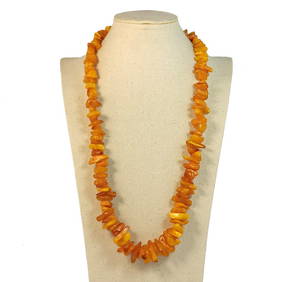
BEAUTIFUL NATURAL BALTIC BUTTERSCOTCH AMBER NECKLACE 61 GRAMS 21"Noble House Collection Gallery4.5(114)See Sold PriceMar 24, 2024
Keith Haring - Ink on New York Map, Best Buddies, Inscribed, Signed, and DatedSapphire Auction Gallery4(67)See Sold PriceMar 02, 2024
Rand McNally Railroad Map Cabinet w/ 21 Railroad MapsRail & Road Auctions4.6(165)See Sold PriceMar 08, 2024
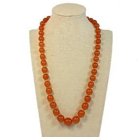
A FANTASTIC LARGE BALTIC AMBER NECKLACE 27" 111grNoble House Collection Gallery4.5(114)See Sold PriceFeb 28, 2024
A GENUINE BALTIC AMBER BUTTERSCOTCH NECKLACE 20" 37grNoble House Collection Gallery4.5(114)See Sold PriceFeb 28, 2024
Putnam - First Map of the State of Ohio by Rufus PutnamTrillium Antique Prints & Rare Books4.5(30)See Sold PriceFeb 24, 2024


![[MAP]. LOTTER, Tobias Conrad. Regionem Mexicanam (1 of 6)](https://p1.liveauctioneers.com/514/38482/16500346_1_x.jpg?height=282&quality=70&version=1363615005)