New South Wales Map. 1884
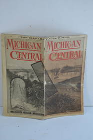
Southern Pacific RR Book West By South-Half South-1890Feb 24, 2024Michigan Central RR May 18, 1884 Public TimetableFeb 24, 2024ASSOCIATED MOTORWAYS "LONDON TO NEW SOUTH WALES" BOOKING OFFICE TIN FLANGE SIGN.Feb 24, 2024LARGE LATE 17TH C. DUTCH CHART OF CANADA, GREAT LAKES, NEW FRANCE, LABRADOR, HUDSON BAY, BY PIERREFeb 24, 2024LARGE EARLY 18TH C. DUTCH CHART OF UPPER NORTH AMERICA, PIERRE MORTIER (1661-1711), FRAMEDFeb 24, 2024Portfolio of 15 County Maps by Robert Morden (English 1650-1703)Feb 24, 2024Nostalgia #401 New South Wales Mounted RiflesMar 15, 2024Nostalgia #254 New South Wales Irish RiflesMar 15, 2024Nostalgia #291 New South Wales Lancers 1900Mar 15, 2024Astronomy.- Richardson (William) A Catalogue of 7385 Stars, chiefly in the Southern Hemisphere,Feb 29, 2024Grote's History of Greece and othersFeb 28, 2024Worried abolitionists on the eve of Civil WarMar 07, 2024Sermon on extraordinary doings of GodMar 07, 2024Philips' Atlas of Counties of EnglandMar 07, 2024Large map of the Americas 1794Mar 07, 2024South Namibia coast. Walvis Bay-Orange River ADMIRALTY sea chart 1881 (1954) mapFeb 28, 2024Framed New South Wales 6th Hole Golf PhotographFeb 29, 2024MAP, World, BankesMar 12, 2024MAP, South Pole, KeizerMar 12, 2024MAP, Game, England, DartonMar 12, 2024MAP, US, Florida, Greyhound Co.Mar 12, 2024MAP, New York, HaywardMar 12, 2024MAP, South America, AaMar 12, 2024MAP, Australia, CookMar 12, 2024