1952 MAY, J.F.K. HANDWRITTEN LETTER & ENVELOPEJohn McInnis Auctioneers,LLC4.6(504)See Sold PriceFeb 25, 2024
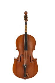
WARNER BECKMAN'S TIGER MAPLE CELLO / SEABROOK NHJohn McInnis Auctioneers,LLC4.6(504)See Sold PriceFeb 25, 2024
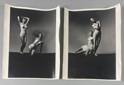
Victor Skrebneski Lingerie Fashion PhotographsEpic Auctions and Estate Sales4.6(204)See Sold PriceMar 02, 2024
[DOUGLASS, Frederick (1818-1895)]. ROBERTS, J.B., photographer. CDV of Frederick Douglass.Freeman's | Hindman4.4(1.6k)See Sold PriceFeb 27, 2024
1952 J.F.K. for SENATE TEAS & RECEPTION MATERIALJohn McInnis Auctioneers,LLC4.6(504)See Sold PriceFeb 25, 2024
HUGH D. AUCHINCLOSS' 70th BIRTHDAY with FAMILYJohn McInnis Auctioneers,LLC4.6(504)See Sold PriceFeb 25, 2024
CAROLINE KENNEDY at BAILEYS BEACH, NEWPORT, RIJohn McInnis Auctioneers,LLC4.6(504)See Sold PriceFeb 25, 2024
WILLIAM LINSMAN PHOTO SIGNED by JACKIE KENNEDYJohn McInnis Auctioneers,LLC4.6(504)See Sold PriceFeb 25, 2024
SoldJ. B. Homann Map of Moravia & Czechoslovakia 1750Johann B. Homann Map of Moravia & Czechoslovakia, 1750. Map titled "Marchionatus Moraviae Circuli Znoymensis et Iglaviensis" Map measures 23" x 19.25" image size, 25-7/8" x 21.5" sheet size. Unframed,See Sold Price
SoldJ. B. Homann Map of Moravia & Czechoslovakia 1750Johann B. Homann Map of Moravia & Czechoslovakia, 1750. Map titled "Marchionatus Moraviae Circuli Znoymensis et Iglaviensis" Map measures 23" x 19.25" image size, 25-7/8" x 21.5" sheet size. Unframed,See Sold Price
SoldJ. B. Homann Map of Czechoslovakia & Hungary 1737Johann B. Homann map of Czechoslovakia & Hungary, 1737. Map titled "Marchionatus Moraviae Circuli Hradistiensis" Map measures 25.75" x 21.5" sheet size. Unframed, loose and not glued or mounted. ProveSee Sold Price
SoldJ. B. Homann Map of Czechoslovakia & Hungary 1737Johann B. Homann map of Czechoslovakia & Hungary, 1737. Map titled "Marchionatus Moraviae Circuli Hradistiensis" Map measures 25.75" x 21.5" sheet size. Unframed, loose and not glued or mounted. If loSee Sold Price
Two J. B. Homann Maps of MoraviaMarchionatus Moraviae Circulus Brunnensis andMarchinatus Moraviae Circuli Znoymensiseach 19 1/2" x 23 1/2" (sight)See Sold Price
Two J. B. Homann Maps of MoraviaMarchionatus Moraviae Circulus Brunnensis and Marchinatus Moraviae Circuli Znoymensis each 19 1/2" x 23 1/2" (sight)See Sold Price
SoldJ. B. Homann Map of Germany 1750J. B. Homann Map of Germany, 1750. Map titled "Tabula Geographica: Principatus Gotha, Coburg et Altenburg". Map measures 25-5/8" x 21.5" sheet size. Unframed, loose and not glued or mounted. ProvenancSee Sold Price
SoldJ. B. Homann Map of Germany 1750J. B. Homann Map of Germany, 1750. Map titled "Saxoniae Tractus Ducatum Magdebur". Map measures 25-5/8" x 21.5" sheet size. Unframed, loose and not glued or mounted. Provenance: C.D. Raymond & Son colSee Sold Price
J. B. Homann Map of Germany 1750J. B. Homann Map of Germany, 1750. Map titled "Tabula Geographica: Principatus Gotha, Coburg et Altenburg". Map measures 25-5/8" x 21.5" sheet size. Unframed, loose and not glued or mounted. If lot isSee Sold Price
J. B. Homann Map of Germany 1750J. B. Homann Map of Germany, 1750. Map titled "Saxoniae Tractus Ducatum Magdebur". Map measures 25-5/8" x 21.5" sheet size. Unframed, loose and not glued or mounted. If lot is absent of a condition reSee Sold Price
SoldTwo hand coloured engraved maps: J.B. Homann,Two hand coloured engraved maps: J.B. Homann, 'Comitatus Flandriae' 1750; Th. Danckerts, 'Judaea sive Sancta Terra quae Israelitarum ...' 1690, 49 x 59,5 - 49 x 56,5 cmSee Sold Price
Bohemia (Czech rep) & Moravia (Slovakia) 1762 by HomannTitle: Bohemia (Czech rep) & Moravia (Slovakia) 1762 by Homann Heirs Date/Period: 1762 Materials: Copper plate engraved Size: 24 x 20 1/2" 1762, by J. B. Homann & Homann Heirs, from "Atlas HomannianusSee Sold Price
Bohemia (Czech rep) & Moravia (Slovakia) 1762 by HomannTitle: Bohemia (Czech rep) & Moravia (Slovakia) 1762 by Homann Heirs Date/Period: 1762 Materials: Copper plate engraved Size: 24 x 20 1/2" 1762, by J. B. Homann & Homann Heirs, from "Atlas HomannianusSee Sold Price
Bohemia (Czech rep) & Moravia (Slovakia) 1762 by HomannTitle: Bohemia (Czech rep) & Moravia (Slovakia) 1762 by Homann Heirs Date/Period: 1762 Materials: Copper plate engraved Size: 24 x 20 1/2" 1762, by J. B. Homann & Homann Heirs, from "Atlas HomannianusSee Sold Price
Bohemia (Czech rep) & Moravia (Slovakia) 1762 by HomannTitle: Bohemia (Czech rep) & Moravia (Slovakia) 1762 by Homann Heirs Date/Period: 1762 Materials: Copper plate engraved Size: 24 x 20 1/2" Description: 1762, by J. B. Homann & Homann Heirs, from "AtlaSee Sold Price
Bohemia (Czech rep) & Moravia (Slovakia) 1762 by HomannTitle: Bohemia (Czech rep) & Moravia (Slovakia) 1762 by Homann Heirs Date/Period: 1762 Materials: Copper plate engraved Size: 24 x 20 1/2" Description: 1762, by J. B. Homann & Homann Heirs, from "AtlaSee Sold Price
A FINE MAP OF MORAVIACirca 1706. Tabula Generalis Marchionatus Moraviae in Sex Circulos Divisae. 25" x 21 ¾". By Johann Baptist Homann, (1663-1724). A beautiful map of today's Czechoslovakia as bordered by Austria, HungaSee Sold Price
SoldJ. B. Homann map of SicilyCartographer: J.B. Homann Title: Regnorum Siciliae et Sardiniae nec non Melitae seu Maltae Insula cum Adjectis Italiae et Africae Litoribus Nova Tabula ... Subject: Sicily, Sardinia Published: NurembeSee Sold Price
SoldJ. B. Homann Map of Brazil & Amazon 1746J. B. Homann Map of Brazil & the Amazon Region, 1746. Map titled "Tabula Americae Specialis Geographica Regni Peru Brasiliae, Terrae Firmae". Map measures 23.5" x 19-7/8" sheet size. Unframed, loose aSee Sold Price
SoldJ. B. Homann, Map of Colonial New England, 1720.Johann Baptist Homann, "Nova Anglia Septentrionali Americae implantata Anglorumque coloniis florentissima" Map of Colonial New England, 1720 .(SVAG2205) {WK} Measurements: 22.5 x 19 inches Condition:See Sold Price
SoldJ. B. Homann map of ItalyCartographer: Jean Baptiste Homann Title: Status Reipublicae Genuensis nec non Prospectuum ... Subject: Italy Published: Nuremberg Date: c. 1730 Description: The title placed in the middle makes thisSee Sold Price
SoldJ. B. Homann Map of Germany 1740J. B. Homann Map of Germany, 1740. Map titled "Totius Marchionatus Lusatiae". Map measures 25.25" x 21.5" sheet size. Unframed, loose and not glued or mounted. Provenance: C.D. Raymond & Son collectioSee Sold Price
J. B. Homann Map of Germany 1740J. B. Homann Map of Germany, 1740. Map titled "Totius Marchionatus Lusatiae". Map measures 25.25" x 21.5" sheet size. Unframed, loose and not glued or mounted. If lot is absent of a condition report oSee Sold Price
SoldJ.B. HOMANN ANTIQUE MAP OF MEXICO & NEW SPAINJ. B. Homann's map of Mexico, Florida, New England, the West Indies, and the Mississippi Valley. Dimensions: (Frame) H 20.5" x W 24.5", (Sight) H 18.5" x W 22..25" Condition: Colors faded. Some wear tSee Sold Price
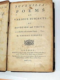
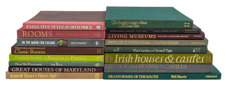
Thomas Gibbons Juvenalia 1750 Very Rare 1st Edition Full CalfLuis Porretta Fine Arts4.3(10)See Sold PriceMar 02, 2024
1963 J.F.K. for US PRESIDENT RE-ELECTION MATERIALJohn McInnis Auctioneers,LLC4.6(504)See Sold PriceFeb 25, 2024
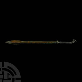
Western Asiatic Bronze Spearhead with Decorative Supports and Blood ChannelsTimeLine Auctions Ltd.4.6(182)See Sold PriceMar 07, 2024
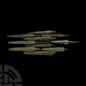
Western Asiatic Bronze Arrowheads, Javelin Heads and DaggersTimeLine Auctions Ltd.4.6(182)See Sold PriceMar 07, 2024
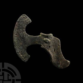
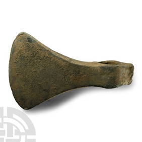
Large Western Asiatic Bronze Socketted AxeheadTimeLine Auctions Ltd.4.6(182)See Sold PriceMar 07, 2024
1736 LARGE MAP OF SILESIA POLAND OPPAVIENSIS antique 25 by 34 3/4"Jasper524.5(9.8k)See Sold PriceFeb 28, 2024
1736 LARGE MAP OF SILESIA POLAND KARNOVIENSIS antique 25 x 4 3/4" Duchy of KrnovJasper524.5(9.8k)See Sold PriceFeb 28, 2024


![[DOUGLASS, Frederick (1818-1895)]. ROBERTS, J.B., photographer. CDV of Frederick Douglass. (1 of 2)](https://p1.liveauctioneers.com/197/319238/171467829_1_x.jpg?height=282&quality=70&version=1707520367)