Marc Chagall-Limited Edition -Paris Opera Ceiling after ChagallArt Legacy Auctions4.5(217)See Sold PriceFeb 24, 2024
Salvador Dali Pantagruel Limited Edition Lithograph Hand signed and numberedArt Legacy Auctions4.5(217)See Sold PriceFeb 24, 2024
Pablo Picasso Bouquet of Peace Collection Domaine Picasso Limited Edition on paper.Art Legacy Auctions4.5(217)See Sold PriceFeb 24, 2024
A RARE MAXFIELD PARRISH JACK AND THE BEANSTALK PRINTSoulis Auctions4.8(953)See Sold PriceFeb 24, 2024
LARGE MECHANICAL PRINT 'STARS' AFTER MAXFIELD PARRISHSoulis Auctions4.8(953)See Sold PriceFeb 24, 2024
Heinrich Aldegrever, etc. 15 old master prints. 16th-17th centuries. Aldegrever works include "ManTremont Auctions4.6(293)See Sold PriceFeb 25, 2024
SoldMathew Carey map of the MidwestMathew Carey, Philadelphia, circa 1818. Hand colored lithograph map entitled "Upper Territories of the United States". Depicts the upper Midwestern States and the Great Lakes. Slight toning. Image 8 3See Sold Price
SoldCAREY, MATHEW. The Upper Territories of the UnitedCAREY, MATHEW. The Upper Territories of the United States. Double-page engraved map of the American Midwest. 21¾x17½ inches sheet size, wide margins; original hand-color in outline; minor ofSee Sold Price
Extremely scarce 1814 Mathew Carey map of New YorkHighly desirable and collectible War of 1812-era map of New York by Samuel Lewis. From a very scarce 1816 edition of Carey’s General Atlas (same map as the 1814 atlas). Map is colored by countieSee Sold Price
SoldMathew Carey map of Mississippi & Alabama 1818Title: The State of Mississippi Author: Carey, Mathew Description: Copper-engraved map, hand-colored in outline. Engraved by Shallus. 30x36 cm.Later issue of the 1818 map "The State of Mississippi andSee Sold Price
SoldMathew Carey Map, 1818Mathew Carey, "The State of Mississippi and Alabama Territory", Philadelphia, 1818, hand-colored in outline, one of the earliest maps to show Alabama territory, 14 in. x 12 in., unframed. Provenance:See Sold Price
SoldMathew Carey MapMathew Carey, "Louisiana", London, 1814, hand-colored map from Carey's General Atlas, one of the earliest maps of Louisiana to appear in an atlas, 15 1/2 in. x 17 in., unframedSee Sold Price
Scarce 1816 Mathew Carey map of PolandVery scarce map of Poland from Mathew Carey’s scarce and uncommon 1816 edition of his General Atlas. Includes a table identifying areas of the map claimed by Russia, Prussia and Austria. An unusSee Sold Price
Very scarce 1816 map of Massachusetts by M. CareyMathew Carey's map of Massachusetts, from the elusive 1816 edition of Carey's General Atlas. This extremely scarce map shows lighthouses, bays, islands, points, shoals, harbors, turnpikes, rivers, lakSee Sold Price
Scarce Carey map of St. Domingo, 1816Scarce 1816 atlas edition of Mathew Carey's map of Haiti, the western half of the island of St. Domingo in the West Indies. Map appears to be identical to the one in Carey’s 1814 General Atlas.See Sold Price
First state of an important map of the Trans-Mississippi WestMathew Carey's map, Missouri Territory formerly Louisiana, is one of the seminal maps of the period and the first atlas map to provide the cartographic detail derived from the return of the Lewis & ClSee Sold Price
Sold1814 MATHEW CAREY HAND-COLORED MAP OF VIRGINIA, ti1814 MATHEW CAREY HAND-COLORED MAP OF VIRGINIA, titled "A Correct Map of Virginia", with "Meridian of Philad" at upper right edge and "17" in upper right plate margin, not framed. First quarter 19th cSee Sold Price
SoldMathew Carey, Two MapsMathew Carey, "Louisiana" and "Missouri Territory formerly Louisiana", Philadelphia, 1814, two hand-colored engraved maps from General Atlas, the first world atlas published in the US, 15 1/4 in. x 17See Sold Price
SoldWorld Map- MappamondoMathew Carey. A Map of the World from the best Authorities. 1795. Incisione in rame con acquerellatura coeva. mm 295x520 Foglio: mm 440x555. Titolo entro cornice ovale in alto al centro. Mappamondo coSee Sold Price
SoldMATHEW CAREY (AMERICAN, 1760-1839) MAP OF DELAWAREMATHEW CAREY (AMERICAN, 1760-1839) MAP OF DELAWARE, hand-colored engraving on paper, titled "Delaware from the best Authorities", engraved by William Barker, published Philadelphia, 1795. Modern frameSee Sold Price
Mathew Carey 1814. Polar Map.A map of the countries situate about the North Pole as far as the 50th degree of north latitude. 10 1/2" x 11" Hand Colored.See Sold Price
SoldMap. Mathew Carey: The Province of Maine.Mathew Carey: The Province of Maine From the Best Authorities By Samuel Lewis 1794. 10 1/4 x 15"See Sold Price
SoldGrp: 9 Maps of the Americas Africa and the WorldGroup of nine maps of various regions of the world. Includes J. Warr Jr. hand colored map of the United States, Philadelphia, ca. 1822; Mathew Carey (1760-1839) map of Africa "Africa from the best AutSee Sold Price
SoldCarey's American Pocket Atlas. Phila 1796.MAP - CAREY, Mathew. Carey's American Pocket Atlas.Philadelphia: Carey, 1796. 12mo (160x90 mm). 15 engraved folding maps, only (of 19); lacks the general map of the United States, and maps oSee Sold Price
Extremely scarce map of Delaware, M. Carey 1814One of the earliest obtainable maps of the State of Delaware. Mathew Carey's extremely scarce map titled “Delaware from the Best Authorities” from the scarce 1816 edition of Carey's GeneraSee Sold Price
SoldMATHEW CAREY (IRISH / AMERICAN, 1760-1839) MAP OFMATHEW CAREY (IRISH / AMERICAN, 1760-1839) MAP OF VIRGINIA, hand-colored, on laid paper, titled "A / Correct Map of / VIRGINIA" in upper right quadrant with scale; printed for Carey's "General Atlas".See Sold Price
SoldMathew Carey (19th c.mapmaker) "A Map of the WorlMathew Carey (19th c.mapmaker) "A Map of the World from the best Authorities," hand colored copper engraving, ca. 1818, 12"x 21," framed 25"x 34," label verso, Shows the track of Captain Cooks voyagesSee Sold Price
Sold4 TN/KY Maps, incl. Mathew Carey, 1816Two (2) Maps of Tennessee, two (2) maps of Tennessee and Kentucky, 4 items total. 1st item: Tennessee map, from American Pocket Atlas, published by Mathew Carey, Philadelphia, 1816. Copper plate engraSee Sold Price
SoldLEWIS, SAMUEL; and CAREY, MATHEW. A Map of the UnitedLEWIS, SAMUEL; and CAREY, MATHEW. A Map of the United States: Compiled Chiefly from the State Maps and Other Authentic Information. Large engraved map of the United States east of the Mississippi RiveSee Sold Price
SoldMATHEW CAREY (IRISH / AMERICAN, 1760-1839) MAP OFMATHEW CAREY (IRISH / AMERICAN, 1760-1839) MAP OF VIRGINIA, on laid paper, titled "VIRGINIA" to upper left corner, above scale, lettered "W. Baker, sculp." to lower right corner margin; after work ofSee Sold Price
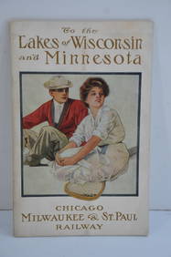
Chicago Milwaukee and St Paul RY To the Lakes of Wisconsin and Minnesota Book-1909JM Hobby Supply and Railroad Artifact Auctions4.4(126)See Sold PriceFeb 24, 2024
18TH C. ANTIQUE MAP: FRENCH & INDIAN WAR, FRAMEDThomaston Place Auction Galleries4.4(386)See Sold PriceFeb 24, 2024
Rand McNally Railroad Map Cabinet w/ 21 Railroad MapsRail & Road Auctions4.6(165)See Sold PriceMar 08, 2024
The First World War A Photographic History 1933. 1st EditionNorth American Artifact Auctions4.6(182)See Sold PriceApr 20, 2024
1870 Commentary on the Gospels Vol I St Mathew & Vol II St Mark 1st EditionsNorth American Artifact Auctions4.6(182)See Sold PriceApr 20, 2024
Battle of the Nile: Disposition of the English & French Fleets, at the Commencement of the Action,Trillium Antique Prints & Rare Books4.5(30)See Sold PriceFeb 24, 2024
Putnam - First Map of the State of Ohio by Rufus PutnamTrillium Antique Prints & Rare Books4.5(30)See Sold PriceFeb 24, 2024
Carey, pub. 1796 - A Chart of the West IndiesTrillium Antique Prints & Rare Books4.5(30)See Sold PriceFeb 24, 2024
Carey, pub. 1796 - Map of the State of MarylandTrillium Antique Prints & Rare Books4.5(30)See Sold PriceFeb 24, 2024
Carey, pub. 1796 - Map of GeorgiaTrillium Antique Prints & Rare Books4.5(30)See Sold PriceFeb 24, 2024
Carey, pub. 1796 - Map of The State of South CarolinaTrillium Antique Prints & Rare Books4.5(30)See Sold PriceFeb 24, 2024
Carey, pub. 1796 - Map of KentuckyTrillium Antique Prints & Rare Books4.5(30)See Sold PriceFeb 24, 2024
Carey, pub. 1796 - Map of the Tennassee State formerly part of North Carolina (Tennessee)Trillium Antique Prints & Rare Books4.5(30)See Sold PriceFeb 24, 2024
1822 MAP of LEEWARD ISLANDS GEOGRAPHICAL STATISTICAL HISTORICAL antique 17.5x22"Jasper524.5(9.8k)See Sold PriceFeb 27, 2024
1822 MAP of SOUTH AMERICA GEOGRAPHICAL STATISTICAL HISTORICAL antique 17.5x 22"Jasper524.5(9.8k)See Sold PriceFeb 27, 2024
1816 MAP SOUTHERN PART OF RUSSIA or MUSCOVY in EUROPE copper engraving ANTIQUEJasper524.5(9.8k)See Sold PriceFeb 27, 2024
1816 MAP NORTHERN PART OF RUSSIA or MUSCOVY in EUROPE copper engraving ANTIQUEJasper524.5(9.8k)See Sold PriceFeb 27, 2024
1822 MAP of NORTH & SOUTH AMERICA GEOGRAPHICAL STATISTICAL HISTORICAL antiqueJasper524.5(9.8k)See Sold PriceFeb 27, 2024
1822 MAP of CHILI GEOGRAPHICAL STATISTICAL HISTORICAL antique 17.5x 22" CHILEJasper524.5(9.8k)See Sold PriceFeb 27, 2024
Geographical, Statistical, and Historical Map of the Leeward Islands.Jasper524.5(9.8k)See Sold PriceFeb 27, 2024
Geographical Statistical and Historical Map of the Windward IslandsJasper524.5(9.8k)See Sold PriceFeb 27, 2024
Geographical, Statistical, and Historical Map of the West Indies.Jasper524.5(9.8k)See Sold PriceFeb 27, 2024