SoldAntique French Map of MississippiAntique French Map of Mississippi , "Carte Geographique, Statistique et Historique du Mississipi", Paris, Buchon, 1825, sight 21 in. x 27 1/2 in., framed Provenance: Estate of Julia Evans ReedSee Sold Price
SoldAntique French Map of Chili Signed J. De Laet. 1625Frame 20 1/2"x19" Map 15 1/2"x13 1/2"See Sold Price
Bellin: Antique French Map Plan of Boston, 1757Title/Content of Map: Antique French Map and Plan of Boston, Massachusetts. Plan de la Ville de Boston et ses Environs Date Printed: 1757 Cartographer: Bellin, Jacques Nicolas Size (inches): 10 x 6 OnSee Sold Price
SoldAntique French Map LVTETIA VULGO PARIS ANNO 1575,Antique French Map LVTETIA VULGO PARIS ANNO 1575, on LANA watermark paper. Sheet size: 15 ¾" x 20 1/8"See Sold Price
SoldAntique French Map and Plan of Boston, MassachusettsTitle/Content of Map: Antique French Map and Plan of Boston, Massachusetts Date Printed: 1757 Cartographer: Bellin, Jacques Nicolas Size (in): 10 x 6 One of the earliest obtainable town plans of BostoSee Sold Price
SoldSixteen Antique French MapsSixteen Antique French Maps , 18th c., by Amedee Francois Frezier, 9 in. x 12 1/2 in Provenance: Property deaccessioned from the Louisiana State Museum, proceeds to be used for new acquisitions or theSee Sold Price
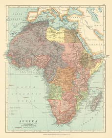
Sold(4) ANTIQUE FRENCH MAPS - FROM CHRISTIE'S AUCTIONFour antique French maps of Africa & Middle East. They were purchased from Christie's auction in 1994. Measures 8.75" x 7.75" to 16.25" x 13.5" w/ frames.See Sold Price
SoldTwelve Antique French Maps by BellinTwelve Antique French Maps by Bellin , 1750-1767, most sheets 25 in. x 36 in Provenance: Property deaccessioned from the Louisiana State Museum, proceeds to be used for new acquisitions or the directSee Sold Price
Antique South Pacific map with oddly-shaped AustraliaTitle/Content of Map: Antique South Pacific map with oddly-shaped Australia Date Printed: 1753 Cartographer: Bellin, Jacques Nicolas Size (in): 14 x 8 Fine 18th-century antique French map of the SouthSee Sold Price
SoldAntique French J. Forest World Map GlobeDESCRIPTION: Antique terrestrial globe world map, drawn up by the geographer J.Forest, from 17-19 rue de Buci in Paris. Scale 1/50.000.000. With a solid wooden block base and interior light. Joseph FoSee Sold Price
Bellin: Antique Map of French Florida, 1756Map: Karte von den Kusten des Franzoisischen Florida Cartographer: Bellin Place & Date: Leipzig / 1756 Size: 5 3/4" x 8" Condition: b&w; light overall age toning Bellin's very interesting map of the cSee Sold Price
SoldANTIQUE MAPS OF FRENCH CITIES, ROUEN, PARIS, CAHORSIncludes map etching of Cahors and environs, 5 x 3 inch sight size, 11 x 9.5 inch frame. 'Gouvernement de Chaors,' 5 x 7 inch sight size, in 11.75 x 13.75 inch frame. Early 'Rouen' with Seine River, 1See Sold Price
SoldBarnes: Antique Map of French Quarter, New Orleans 1942Title/Content of Map: 1942 Myra Z Barnes Map of French Quarter, New Orleans -- Le Vieux Carre de la Nouvelle Orleans Date Printed: 1942 Cartographer: Myra Z Barnes Size: 20.5 X 30.8 in. Condition: VerSee Sold Price
SoldFrederick the Great MEMOIRES POUR SERVIR A L'HISTOIREFrederick the Great MEMOIRES POUR SERVIR A L'HISTOIRE DE LA MAISON DE BRANDEBOURG 1751 Antique History French Genealogy Explication Folding Maps Joachim II George Guillaume Frederic Guillaume Title: MSee Sold Price
SoldA MONSEIGNUER LE DAUPHIN 2 HEMISPHERE COLOR MAPAntique A. Monseignuer le Dauphin French color map depicting the globe in two hemispheres. Mounted in a wooden frame behind glass screen. Map measures approx. 22" height x 36" width (55.8cm x 91.4cm)See Sold Price
Weigel: Antique Map of Southern French Antilles, 1718Insulae Antillae Franciae Inferiores A dramatic German early 18th-century map of lower French Antilles, including St. Lucia, St. Vincent and the Grenadines, Grenada, and Barbados, based on "written coSee Sold Price
Sold1799 Antique Geographical Dictionary Fold Out World Map1799 Antique Geographical Dictionary In French With Fold Out Map Of The World. Volume 1. Printed In Bruxelles. Good Condition, Some Foxing, Some Wear Of The Binding. Size 8 By 5" Please note that thisSee Sold Price
Soldde Bry: Antique French Florida Colony View, 1590Map: The French Commander Erects a Column with the Arms of the King of France Cartographer: Theodor de Bry Place & Date: Frankfurt / 1590 Size: 9" x 13 1/4" (overall sheet) Condition: b&w as publishedSee Sold Price
Sanson: Antique Map of North America, 1735Title: Amerique Septentrionale par N. Sanson d'Abbeville Geographe du Roy, Small 1735 French map with California as an Island and misshapen Great Lakes Map maker: Nicolas Sanson, Introduction a l'histSee Sold Price
Sanson: Antique Map of North America, 1735Title: Amerique Septentrionale par N. Sanson d'Abbeville Geographe du Roy. Small 1735 French map with California as an Island and misshapen Great Lakes Map maker: Nicolas Sanson, Introduction a l'histSee Sold Price
Michel: Antique French Pocket Atlas Universal, 1834Title/Content of Map: Atlas Universel dedie au General Baron de Richemont ex. Commandant l'Ecole St. Cyr. Atlas Universal a small French pocket Atlas Date Printed: 1834 Cartographer: Michel fils SizeSee Sold Price
18TH C. ANTIQUE MAP: FRENCH & INDIAN WAR, FRAMEDThomaston Place Auction Galleries4.4(386)See Sold PriceFeb 24, 2024
Duval - Pair: Map of Georgia & Map of Moscow, RussiaTrillium Antique Prints & Rare Books4.5(30)See Sold PriceFeb 24, 2024
Duval - Pair: Map of India & Map of MaldivesTrillium Antique Prints & Rare Books4.5(30)See Sold PriceFeb 24, 2024
UPPER/HAUTE VOLTA. Burkina Faso. French West Africa. Ouagadougou plan 1929 mapJasper524.5(9.8k)See Sold PriceFeb 28, 2024
Colonial Africa. British German French Spanish Portuguese Italian TIMES 1900 mapJasper524.5(9.8k)See Sold PriceFeb 28, 2024
COLONIES FRANÇAISES en AFRIQUE. Africa Sénégal Madagascar. LEVASSEUR c1850 mapJasper524.5(9.8k)See Sold PriceFeb 28, 2024
Africa. French West/Equatorial. Tanganyika Belgian Congo. STANFORD c1925 mapJasper524.5(9.8k)See Sold PriceFeb 28, 2024
Colonial Africa North-West. British French. Nigeria Sahara. THE TIMES 1895 mapJasper524.5(9.8k)See Sold PriceFeb 28, 2024
Colonial Central Africa. Belgian Congo. French Equatorial Africa. TIMES 1922 mapJasper524.5(9.8k)See Sold PriceFeb 28, 2024
COLONIAL AFRICA. British French German Italian Portugal Spain.STANFORD 1906 mapJasper524.5(9.8k)See Sold PriceFeb 28, 2024
UPPER/HAUTE VOLTA. Burkina Faso. French West Africa. Ouagadougou plan 1931 mapJasper524.5(9.8k)See Sold PriceFeb 28, 2024
Colonial Africa. British German French Spanish Portuguese Italian TIMES 1895 mapJasper524.5(9.8k)See Sold PriceFeb 28, 2024
Colonial Africa North-West. British French. Nigeria Sahara. THE TIMES 1900 mapJasper524.5(9.8k)See Sold PriceFeb 28, 2024
L'Afrique Françoise ou du Senegal'. French West Africa. DE L’ISLE 1727 mapJasper524.5(9.8k)See Sold PriceFeb 28, 2024
1792 OLD INDIA HISTORY ANTIQUE ILLUSTRATED WITH MAPS OF THE EIGHTEENTH CENTURY IN FRENCHNY Elizabeth 4.3(84)See Sold PriceMar 03, 2024
James Cook - Map of the Friendly Isles - Tonga IslandsProverde Auctions4.3(3)See Sold PriceFeb 28, 2024