SoldJohn Speede - Map of PolandJohn Speede- A Newe Mape of Poland 'Done Into English by J. Speede, bordered with views, arms and regional costumes, engraved map by Dirck Grijp, hand-colored, English text verso, fold reinforced versSee Sold Price
Sold1626 John Speede map Kingdom of Denmark1626 John Speede map of the Kingdom of Denmark- two sheet hand colored map w/ towns, costumes, & types vignettes border, double framed, 16" x 20 1/2"See Sold Price
Sold1676 John Speede map of the Invasions of England &1676 John Speede map of the Invasions of England & Ireland 2 sheets 16.5” x 21”See Sold Price
Sold1610 John Speede Map of Cambridgeshire1610 John Speede hand colored two-sheet map of Cambridgeshire, on laid paper, double sided glass frame, sight 14 3/4" x 20 1/4"See Sold Price
Soldca 1616 John Speede map The Province Ulster 2 sheetsca 1616 John Speede map The Province Ulster 2 sheets 16” x 21”See Sold Price
SoldJohn Speede map of Oxfordshire, described with citieJohn Speede map of Oxfordshire, described with citie and armes of the colleges of the famous university Ao. 1605, with hand-coloured decoration and a list of the hundreds verso, 38cm x 51cm39.5 x 53cmSee Sold Price
SoldJohn Speede Map of Britain & 2 other mapsJohn Speede engraving Two Maps of Britain as divided at the time of the Saxons 15 x 20in. New Mappe of the Romane Empire, 15 x 20in and A New Map of Asia, 19 x 22in.See Sold Price
SoldAn eighteenth century John Speede map of NorthumberlandAn eighteenth century John Speede map of Northumberland, the handcoloured plate with town maps of Newcastle and Berwick and other vignettes, framed with key also under glass to verso. (21.5in x 16.5inSee Sold Price
SoldTwo Early John Speede MapsThe Kingdome of Persia with the cheef citties and habites described. Sheet size: 22" x 17 1/2" Plate impression visible. Plate size: 20 1/2" x 15 3/4". Hand colored on laid paper.See Sold Price
SoldA 17th century John Speede County Map of CambridgshireA 17th century John Speede County Map of Cambridgshire (sic.), dated 1610, 39 x 53 cmSee Sold Price
SoldJohn SPEEDE (1552-1629) MapArtist: John SPEEDE (1552-1629). Title: Hand colored "DENBIGH SHIRE" map. Size: 15 1/2 x 20 1/2 in. Frame: 22 1/2 x 27 1/2 in. Condition: Good, lite toning to paper. Created: 1610. Medium: Hand coloreSee Sold Price
SoldJohn Speede - engraved map with hand-colouring -John Speede Engraved map with hand-colouring 'The Invasions of England and Ireland' 41cm x 54cm Glazed frame with text to reverseSee Sold Price
SoldA Newe Mape of Poland Done into English by J. SpeedeJOHN SPEEDE New Map of Poland, annotated to scaled key 'Humble 1626', framed, 54cm x 24cm, Edward Gordon label verso. CONDITION REPORT: Centre fold. Rather brown overall. Colours slightly faded to marSee Sold Price
SoldMap, John Speede, Brecon, 1610, WalesHand colored map, John Speede, 1610, Breknore, both Shyre and town, hand colored, depicting the Brecon Beacons in Wales, note: Brecknockshire (Welsh: Sir Frycheiniog), also known as the County of BrecSee Sold Price
SoldJohn Speede (1551/2-1629) - Canaan Map, London, 1651.John Speede (1551/2-1629) - Canaan Map, London, 1651. Hand colored. 39x51.5cm. Full title: Canaan / Are to be sold by Tho. Basset in Fleet street, and Ric: Chiswell in St. Pauls Churchyard. BegSee Sold Price
SoldLOT (3) INCLUDING HAND COLORED COPPER ENGRAVED MAPLOT (3) INCLUDING HAND COLORED COPPER ENGRAVED MAP, JOHN SPEEDE, A COAT OF ARMS AND A MAP OF WESTPHALIA, 17/18TH CENTURYSee Sold Price
SoldThree 17th century European mapsThree 17th century European maps: John Speede, [Breknoke, Both Shyre and Towne described], published by J. Sudbury and G. Humbell, London, 1610, frame windowed on reverse to show text, 16 x 21-1/4 in.See Sold Price
SoldEngraved Map, After John SpeedeAfter John Speede (British, 1552-1629), "The Kingdome of Great Britaine and Ireland," hand colored engraving, engraved by Joducus Hondius, english text on verso, overall (with frame): 23.35"h x 27.25"See Sold Price
SoldJohn Speede, antique hand coloured map, Surrey,John Speede, antique hand coloured map, Surrey, described and divided into hundredsSee Sold Price
SoldJohn Speede, British 1552 - 1629 - map of Surrey,John Speede, British 1552 - 1629 - map of Surrey, described and divided into hundreds, inset views of Richmond and Nonsuch Palaces, in upper corners, with columns of arms below, engraved map with handSee Sold Price
SoldTWO HAND-COLORED MAPS BY JOHN SPEEDE 17th CenturyTWO HAND-COLORED MAPS BY JOHN SPEEDE 17th Century "Anglesey Antiently called Mona" and "Merionethshire Described 1610". Speede alternately spelled Speed. Both 16.5" x 21" sight. Both framed 18" x 22.5See Sold Price
SoldJohn Speede (1552-1629) British. "A New Map of ye XV11John Speede (1552-1629) British. "A New Map of ye XV11 Provinces of Low Germanie", Engraving, 17" x 21.5".See Sold Price
SoldJohn Speede, Cornwall, hand coloured engraved map, 38 xJohn Speede, Cornwall, hand coloured engraved map, 38 x 51cmSee Sold Price
SoldJohn Speede (1552-1629) British. "Canaan", Coloured MapJohn Speede (1552-1629) British. "Canaan", Coloured Map c.1611, 15" x 20".See Sold Price
17TH C. MAP OF THE BERKSHIRES BY JOHN SPEED, FRAMEDThomaston Place Auction Galleries4.4(393)See Sold PriceFeb 24, 2024
17TH C. ENGLISH LINEAR MAP BY OGILBY, FRAMEDThomaston Place Auction Galleries4.4(393)See Sold PriceFeb 24, 2024
1963 J.F.K. for US PRESIDENT RE-ELECTION MATERIALJohn McInnis Auctioneers,LLC4.5(505)See Sold PriceFeb 25, 2024
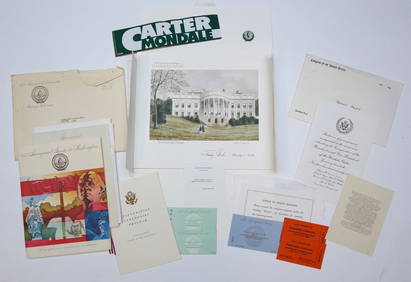
1977 INAUGURATION of PRESIDENT JIMMY CARTERJohn McInnis Auctioneers,LLC4.5(505)See Sold PriceFeb 25, 2024
NORTHERN AFRICA. Morocco Tunisia Algeria. Caravan routes. RAPKIN/TALLIS 1851 mapJasper524.5(9.9k)See Sold PriceFeb 28, 2024
NORTHERN AFRICA. Morocco Tunisia Algeria. Caravan routes.TALLIS/RAPKIN 1851 mapJasper524.5(9.9k)See Sold PriceFeb 28, 2024
NORTHERN AFRICA. Morocco Tunisia Algeria. Caravan routes. RAPKIN/TALLIS 1851 mapJasper524.5(9.9k)See Sold PriceFeb 28, 2024
Guthrie, William 1812 Antique Map. Spain and PortugalAlbion Auctions4.7(341)See Sold PriceMar 01, 2024
ANTIQUE 1686 OPERA OMNIA BY JOHN LIGHTFOOT TELLIMA BOUND FOLIO WITH ISRAEL MAPNY Elizabeth 4.2(86)See Sold PriceMar 03, 2024
John Senex Map of Louisiana & Mississippi RiverWillow Auction House4.5(289)See Sold PriceMar 14, 2024