Timetable, Paper and Ephemera Lot-Eastern USA RailroadsJM Hobby Supply and Railroad Artifact Auctions4.4(126)See Sold PriceFeb 24, 2024
[BASEBALL]. Group of Varied Ephemera, including: Sporting L...Potter & Potter Auctions4.6(539)See Sold PriceMar 07, 2024
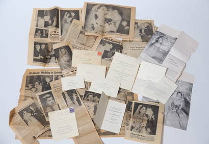
EPHEMERA from the MARRIAGE of MS. EUNICE KENNEDYJohn McInnis Auctioneers,LLC4.6(502)See Sold PriceFeb 25, 2024
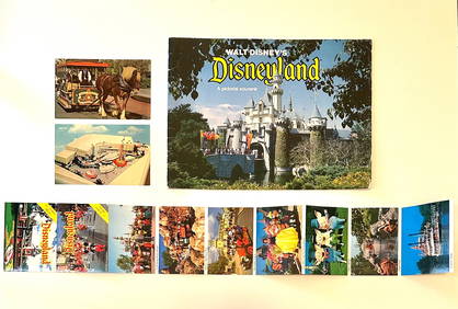
Rare Lot of 1965 and 1977 Walt Disneyland Collectible EphemeraSouth Florida Auction & Estate Sale Services Inc4.5(520)See Sold PriceMar 08, 2024
[CIGARETTE CARDS AND TOBACCO EPHEMERA]. A Group of Six Coll...Potter & Potter Auctions4.6(539)See Sold PriceMar 07, 2024
Group of MLB Ticket and Passes, Other Ephemera: American League Annual PassDana J. Tharp Auctions4.7(268)See Sold PriceFeb 24, 2024
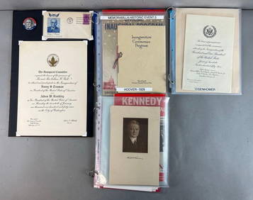
Group of US Presidents inauguration souvenirs, and EphemeraMatthew Bullock Auctioneers4.7(1.8k)See Sold PriceFeb 24, 2024
SoldMining maps of Washington State by Kroll Map CompanyThis is a collection of blueline mining claims maps of seven mining districts in Washington state printed by the Kroll Map Co. of Seattle: Money Creek District, King County, no scale, no date, 19 in.XSee Sold Price
Coal Mining Maps for Washington State (120612)This is a lot of mining maps in blueline and velum detailing the moving of roadway and leases for coal production. Interesting reading from 1928. Five blueline prints, several sketches to scale and miSee Sold Price
SoldCoal Mining Maps for Washington State (120612)This is a lot of mining maps in blueline and velum detailing the moving of roadway and leases for coal production. Interesting reading from 1928. Five blueline prints, several sketches to scale and miSee Sold Price
SoldA MAP, DIE VEREINIGTEN STAATEN VON NORD-AMERIKA, DR. F.A MAP, DIE VEREINIGTEN STAATEN VON NORD-AMERIKA, DR. F. W. STREIT, 1844. A rare and fascinating map of the United States with inset maps of Washington, Boston, Philadelphia, and New York, with nice deSee Sold Price
SoldMontana Gold Mining Company Map (51501)Map of several mines including January, Dewey, Last Chance, Mabel Beal, Alma, Siberia Placer. Clare Jergens and more. Date: State/Country: Montana City/County:See Sold Price
Arbuckle Washington 1889“Washington.” New York: Arbuckle Bros. Coffee Company, ca. 1889. Ca. 3 x 5. Chromolithograph by Donaldson Brothers. Very good condition.; Click here for more maps of the state of Washington PleaseSee Sold Price
Arbuckle Washington 1889“Washington.” New York: Arbuckle Bros. Coffee Company, ca. 1889. Ca. 3 x 5. Chromolithograph by Donaldson Brothers. Very good condition.; Click here for more maps of the state of Washington PleaseSee Sold Price
[MAP]. CASE, TIFFANY & COMPANY. United States. 1853.254. [MAP]. CASE, TIFFANY & COMPANY. Map of the United States [below title, oval portrait of George Washington with eagle and wreath] Washington [below portrait] Hartd. Published by Case TiffSee Sold Price
THE GOLD MINING COMPANY - Western United States ClassicIncorporated in West Virginia in 1886, issued 1895 to Lillie L Broker(?) for 75 shares, cert #949,. Secretary and President's names difficult to read with the full size map. Datelined Washington, D.C.See Sold Price
SoldTHE GOLD MINING COMPANY - Western United States ClassicIncorporated in West Virginia in 1886, issued 1895 to Lillie L Broker(?) for 75 shares, cert #949,. Secretary and President's names difficult to read with the full size map. Datelined Washington, D.C.See Sold Price
Silver Hills Nevada Mines Company Survey Map (122283)Shows Lode Mining Claims in the Tule Canyon Mining District. Esmeralda County, Nevada. Located near Goldfield. Map measures 27 x 42".Date: 7397Country (if not USA): State: NevadaCity: Esmeralda CountySee Sold Price
Silver Hills Nevada Mines Company Survey Map (122283)Shows Lode Mining Claims in the Tule Canyon Mining District. Esmeralda County, Nevada. Located near Goldfield. Map measures 27 x 42".Date: 7397Country if not USA: State: NevadaCity: Esmeralda CountyPrSee Sold Price
Sold[Large Map of Florida] 1846[Large Antique Map of Florida], "The State of Florida Compiled in the Bureau of Topographical Engineers from the Best Authorities", Washington, DC, 1846, with inset maps of the Suwanee River, Cedar KeSee Sold Price
SoldMap of Colorado exhibiting th San Juan, Gunnison andTopographical and township map of the state of Colorado exhibiting the San Juan, Gunnison and California mining regions. Washington, DC: 1880 Louis Nell Civil Engineer.Note: Linen backed, minor splittSee Sold Price
Sold[Map of Louisiana][Antique Map of Louisiana], "State of Louisiana", 1876, by C. Roeser, Department of the Interior, Washington, D.C., chromolithograph by Julius Bien, New York, showing details of towns, cities and railSee Sold Price
SoldMap of Georgetown and WashingtonBeautiful map of "Georgetown and the City of Washington The Capital of the United States of America." 16-1/2"x13-3/4", hand-colored, 1855 by J. Colton and Company. Fine. Framed.See Sold Price
SoldFramed Map - "Plan of the City of Washington"Framed and matted colorized map, "Plan of the City of Washington, The Capital of the United States of America"; drawn and engraved W.H. Gamble.See Sold Price
AlaskaTitle: Alaska Date: c1939 Cartographer: POLAND, EDWIN C. Publisher: KROLL MAP COMPANY Size: 31Height - 39.5Width Provenance: Six insets, three city plans. Shows all airfields. judicial divisions. FoldSee Sold Price
SoldKroll's Framed Road Map of Seattle, Vintage, 1960sFramed road map of Seattle. c.1960s. Published by the Kroll Map Company Inc, Seattle, WA. Overall framed measurement 39.75" x 37".See Sold Price
SoldLeehey-Denny Ranch map Washington State (112339)This is a single large Kittitass County Washington survey by J.L. McPherson. Scale 1 in.-200 ft. c.1911. Black ink on linen original. This map involves a slitting up of the ranch into town lots. The rSee Sold Price
Vintage Washington State Maps Topography MapsVintage Washington State Maps Topography Maps This is a set of 5 Washington State Topography Maps that show Surveys from the early 1900s. These are vintage reprints of the initial surveys done. TheseSee Sold Price
Vintage Washington State Maps Topography MapsVintage Washington State Maps Topography Maps This is a set of 5 Washington State Topography Maps that show Surveys from the early 1900s. These are vintage reprints of the initial surveys done. TheseSee Sold Price
Vintage Washington State Maps Topography MapsVintage Washington State Maps Topography Maps This is a set of 5 Washington State Topography Maps that show Surveys from the early 1900s. These are vintage reprints of the initial surveys done. TheseSee Sold Price
Mounted Western States Mining Map Blowups (118255)Group of five mining map blowups, mounted. Maps include Butte, Montana (23"x 32"), Park City, Utah (21"x 34"), Leadville (21"x 42") and Cripple Creek (23"x 24") Colorado and the Miami District in ArizSee Sold Price
American Express/New York Central Railroad Map of the United States-1934JM Hobby Supply and Railroad Artifact Auctions4.4(126)See Sold PriceFeb 24, 2024
Map of Missouri Highways and Railroads-1921JM Hobby Supply and Railroad Artifact Auctions4.4(126)See Sold PriceFeb 24, 2024
Northern Pacific RR Washington and Northern Idaho Map Folder-1941JM Hobby Supply and Railroad Artifact Auctions4.4(126)See Sold PriceFeb 24, 2024
Rand McNally Railroad Map of Washington-1906JM Hobby Supply and Railroad Artifact Auctions4.4(126)See Sold PriceFeb 24, 2024
Mitchell - Map of the City of Washington (Washington, DC)Trillium Antique Prints & Rare Books4.5(30)See Sold PriceFeb 24, 2024
Goode, George Brown 1884 Lot of 4 Natural History & Meteorology MapsAlbion Auctions4.6(336)See Sold PriceMar 01, 2024
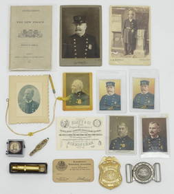
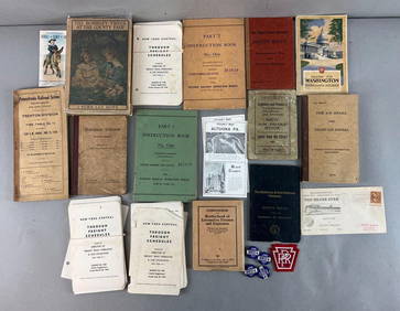
[Spokane, Washington State] Maps, Pins & More (8)Grant Zahajko Auctions, LLC4.8(1k)See Sold PriceMar 06, 2024
Vintage 1920s Rand McNally Auto Trails MapThe Benefit Shop Foundation Inc.4.3(2.9k)See Sold PriceMar 20, 2024


![[BASEBALL]. Group of Varied Ephemera, including: Sporting L... (1 of 2)](https://p1.liveauctioneers.com/928/318880/171361366_1_x.jpg?height=282&quality=70&version=1707501302)

![[CIGARETTE CARDS AND TOBACCO EPHEMERA]. A Group of Six Coll... (1 of 1)](https://p1.liveauctioneers.com/928/318880/171361529_1_x.jpg?height=282&quality=70&version=1707501302)


![[MAP]. CASE, TIFFANY & COMPANY. United States. 1853. (1 of 5)](https://p1.liveauctioneers.com/514/38480/16487112_1_x.jpg?height=282&quality=70&version=1363614971)


![[Large Map of Florida] 1846 (1 of 2)](https://p1.liveauctioneers.com/268/66576/33774402_1_x.jpg?height=282&quality=70&version=1421356640)

![[Map of Louisiana] (1 of 3)](https://p1.liveauctioneers.com/268/27173/10262407_1_x.jpg?height=282&quality=70&version=1320495480)


![[Spokane, Washington State] Maps, Pins & More (8) (1 of 5)](https://p1.liveauctioneers.com/5755/320282/172114031_1_x.jpg?height=282&quality=70&version=1708463029)


