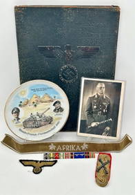
Incredible Named WW2 WWII Luftwaffe Generals German Desk Flag Paperweight with Presentation boxEagles Corps International LLC4.5(107)See Sold PriceMar 10, 2024
Bronze Inkwell Stamped Tiffany Studios New York Age And Authenticity UnknownRbfinearts4.5(579)See Sold PriceFeb 24, 2024
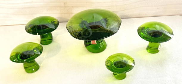
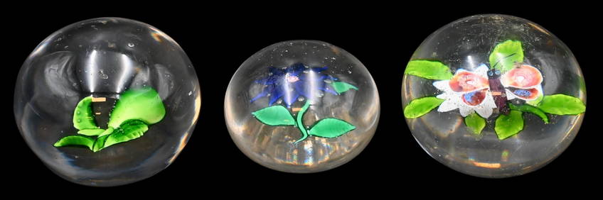
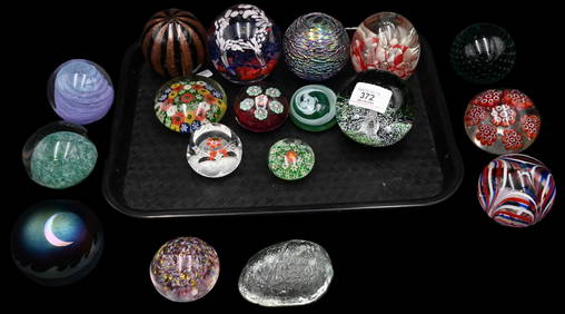
Group of Nine Early Signed Glass PaperweightsNadeau's Auction Gallery4.7(410)See Sold PriceFeb 24, 2024
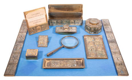
(10 PC) TIFFANY BRONZE DESK SET "BOOKMARK" PATTERNThomaston Place Auction Galleries4.4(394)See Sold PriceFeb 25, 2024
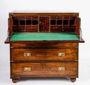
BRASS BOUND MAHOGANY FALL FRONT CAMPAGNE DESKJohn McInnis Auctioneers,LLC4.5(505)See Sold PriceFeb 25, 2024
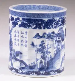
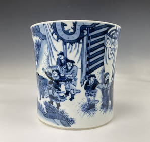
Chinese Blue White Porcelain Brush PotChina Luban Art & Antique, Inc.4.4(79)See Sold PriceFeb 24, 2024
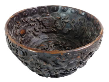
Vintage Chinese 5 Toe Dragon Bat Carved Resin Figural Bowl 6.25 Inches Wide 1.4lbsHess Fine Auctions4.5(213)See Sold PriceMar 02, 2024
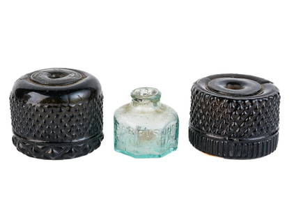
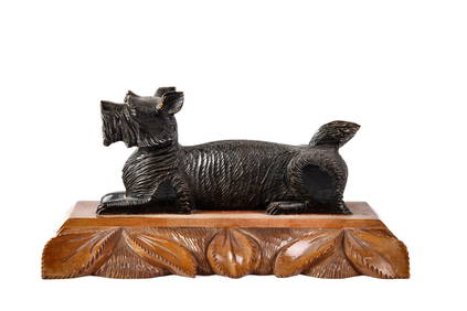
1930s CARVED & PAINTED WOOD SCOTTIE DOG PEN RESTJohn McInnis Auctioneers,LLC4.5(505)See Sold PriceFeb 25, 2024
SoldWorld chart with ship's route in ink, 1861Heading: Author: Hobbs, J.S. Title: A General Chart for the purpose of pricking off a Ship's Tract, from England, &c., Southward and Round the World Place Published: London Publisher:Charles WilsonSee Sold Price
World chart with ship's route in ink, 1861Heading: Author: Hobbs, J.S. Title: A General Chart for the purpose of pricking off a Ship's Tract, from England, &c., Southward and Round the World Place Published: London Publisher:Charles WilsonSee Sold Price
SoldFall River Line Puritan Ship Distance ChartMasschusetts,19th Century Travel distance chart drawn in white ink over blue paper outlining the steamboat's route. Ink, paper,Sight 15" x 20",Frame 18" x 23" From the collection of a Barrington, RhodSee Sold Price
SoldPolish Steam Ship Company world route map mountedPolish Steam Ship Company world route map mounted on canvas with wood rollers pub. 1976 and another Finland Line route map pub.1968 and a quantity of other charts some British inland and coastal waterSee Sold Price
English Channel sea chart. Ports lighthouses mail routes. LARGE 1927 old mapTITLE/CONTENT OF MAP: 'The Baltic Sea; inset Approaches to Stockholm, Hernosand District; Sundsvall District; Soderhamn District; Goteborg; Malmo; Leningrad; Kronstadt Ship Canal; Helsinki; Lepaya; LuSee Sold Price
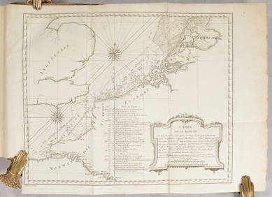
SoldFRAMED MONUMENTAL SHIP CHART WITH ROUTE MARKINGS - 1851FRAMED MONUMENTAL SHIP CHART WITH ROUTE MARKINGS - 1851 E.& G.W. Blunt of New York Nautical Chart, North Atlantic Ocean, 1844, updated to 1851, showing several voyages of the 494 ton bark-rigged sailiSee Sold Price
SoldEarly framed world globe geographic sailing chartEarly framed world globe geographic sailing chart depicting routes traveled in 1630 AD 30x21See Sold Price
SoldUnusual 1872 World map by LloydFrom an 1872 Ohio atlas by H. H. Lloyd comes this unusual hand colored map of the world. With ocean currents, trade winds, monsoons, sargassos, volcanoes and steam ship routes marked. Clean and excellSee Sold Price
SoldWorld chart with discoveries of James Cook 1787Heading: Author: Faden, William Title: A New General Chart of the World, Exhibiting the Whole of the Discoveries made by the late Captain James Cook, F.R.S. with the Tracks of the Ships under his ComSee Sold Price
WORLD MERCATOR showing mail routes to British colonies.TITLE/CONTENT OF MAP: 'The World on Mercator's Projection' Vignettes: Vesuvius; Gibraltar; London; Constantinople; Niagara; The Pyramids of Ghizeh; Pont Neuf, Paris. The steam ship routes to the colonSee Sold Price
WORLD MERCATOR showing mail routes to British colonies.TITLE/CONTENT OF MAP: 'The World on Mercator's Projection' Vignettes: Vesuvius; Gibraltar; London; Constantinople; Niagara; The Pyramids of Ghizeh; Pont Neuf, Paris. The steam ship routes to the colonSee Sold Price
WORLD MERCATOR showing mail routes to British colonies.TITLE/CONTENT OF MAP: 'The World on Mercator's Projection' Vignettes: Vesuvius; Gibraltar; London; Constantinople; Niagara; The Pyramids of Ghizeh; Pont Neuf, Paris. The steam ship routes to the colonSee Sold Price
WORLD MERCATOR showing mail routes to British colonies.TITLE/CONTENT OF MAP: 'The World on Mercator's Projection' Vignettes: Vesuvius; Gibraltar; London; Constantinople; Niagara; The Pyramids of Ghizeh; Pont Neuf, Paris. The steam ship routes to the colonSee Sold Price
WORLD MERCATOR showing mail routes to British colonies. RAPKIN/TALLIS 1851 mapTITLE/CONTENT OF MAP: 'The World on Mercator's Projection' Vignettes: Vesuvius; Gibraltar; London; Constantinople; Niagara; The Pyramids of Ghizeh; Pont Neuf, Paris. The steam ship routes to the colonSee Sold Price
Sold1842 Chart of World Mountains and RiversAuthor: Scott Title: 1842 Chart of World Mountains and Rivers Medium: Ink on Paper Dimensions: 11.5"X9" Description: Chart of world's mountains and rivers dated 1842. Copper plate chart. Engraved by RSee Sold Price
1852 Chart of World's Mountains and RiversAuthor: Johnson Title: 1852 Chart of World's Mountains and Rivers Medium: Ink on Paper Dimensions: 26.5"X18" Description: Rare horizontal map/chart of the world's river and mountains dated 1852. EngraSee Sold Price
SoldWORLD/British Empire. 'Steam routes to the colonies'.TITLE/CONTENT OF MAP: 'The World on Mercator's Projection' Vignettes: Gibraltar; London; Constantinople; Niagara; The Pyramids of Ghizeh; Pont Neuf, Paris; Vesuvius. The steam ship routes to the colonSee Sold Price
BRITISH EMPIRE. Shows steam routes to theTITLE/CONTENT OF MAP: 'The World on Mercator's Projection' Vignettes: Vesuvius; Gibraltar; London; Constantinople; Niagara; The Pyramids of Ghizeh; Pont Neuf, Paris. The steam ship routes to the colonSee Sold Price
BRITISH EMPIRE. Shows steam routes to the colonies.World. RAPKIN/TALLIS 1851 mapCAPTION PRINTED BELOW PICTURE: 'The World on Mercator's Projection' Vignettes: Vesuvius; Gibraltar; London; Constantinople; Niagara; The Pyramids of Ghizeh; Pont Neuf, Paris. The steam ship routes toSee Sold Price
BRITISH EMPIRE. Shows steam routes to theTITLE/CONTENT OF MAP: 'The World on Mercator's Projection' Vignettes: Vesuvius; Gibraltar; London; Constantinople; Niagara; The Pyramids of Ghizeh; Pont Neuf, Paris. The steam ship routes to the colonSee Sold Price
BRITISH EMPIRE. Shows steam routes to theTITLE/CONTENT OF MAP: 'The World on Mercator's Projection'Vignettes: Vesuvius; Gibraltar; London; Constantinople; Niagara; The Pyramids of Ghizeh; Pont Neuf, Paris. The steam ship routes to the coloniSee Sold Price
BRITISH EMPIRE. Shows steam routes to theTITLE/CONTENT OF MAP: 'The World on Mercator's Projection' Vignettes: Vesuvius; Gibraltar; London; Constantinople; Niagara; The Pyramids of Ghizeh; Pont Neuf, Paris. The steam ship routes to the colonSee Sold Price
BRITISH EMPIRE. Shows steam routes to theTITLE/CONTENT OF MAP: 'The World on Mercator's Projection' Vignettes: Vesuvius; Gibraltar; London; Constantinople; Niagara; The Pyramids of Ghizeh; Pont Neuf, Paris. The steam ship routes to the colonSee Sold Price
BRITISH EMPIRE. Shows steam routes to the colonies.World. RAPKIN/TALLIS 1851 mapCAPTION PRINTED BELOW PICTURE: 'The World on Mercator's Projection' Vignettes: Vesuvius; Gibraltar; London; Constantinople; Niagara; The Pyramids of Ghizeh; Pont Neuf, Paris. The steam ship routes toSee Sold Price