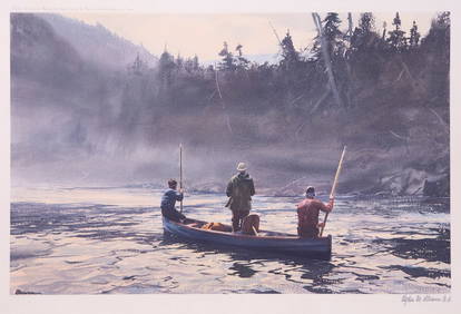
Ogden M. Pleissner (1905-1983), The Blue Boat on the Ste. AnneCopley Fine Art Auctions4.5(40)See Sold PriceFeb 24, 2024
Folk Artist Max Mays' First Baptist Church printBert Gallery Studio Sales4.4(18)See Sold PriceFeb 27, 2024
George Rodrigue "Bullseye (Red)" A.P. ScreenprintNapoleon's Fine Art4.4(75)See Sold PriceFeb 25, 2024
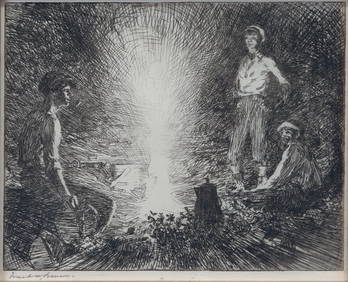
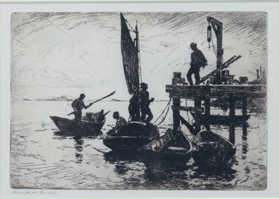
Aiden Lassell Ripley (1896-1969), Two EtchingsCopley Fine Art Auctions4.5(40)See Sold PriceFeb 24, 2024
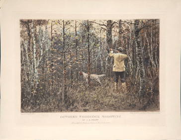
Arthur Burdett Frost (1851-1928), Autumn WoodcockCopley Fine Art Auctions4.5(40)See Sold PriceFeb 24, 2024
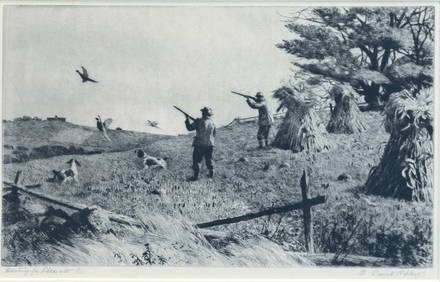
Arthur Burdett Frost (1851-1928), Four Derrydale PrintsCopley Fine Art Auctions4.5(40)See Sold PriceFeb 24, 2024
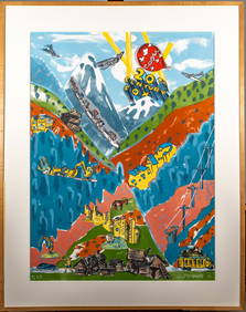
Red Grooms (American, B. 1937) Lithograph “Mountain Time” AP 4/8Magnusson Art Group4.5(46)See Sold PriceMar 14, 2024
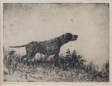
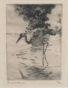
Frank W. Benson (1862-1951), Two Pointer EtchingsCopley Fine Art Auctions4.5(40)See Sold PriceFeb 24, 2024
"The Mail Boat, Venezuela" by Philip Kappel (1901-1981) Antique Signed EtchingCurated Gallery Auctions4.6(120)See Sold PriceFeb 25, 2024
GLO Map of Dakota TerritoryUS. General Land Office. Dakota Territory. Lithograph with original outline color. Washington D.C., U.S. GLO, 1866. 25 1/8" x 22 5/8" sheet, 37" x 34" framed. Dated 1866, the U.S. General Land Office'See Sold Price
SoldGLO, Dakota Territory.UNITED STATES GENERAL LAND OFFICE. Dakota Territory. N.Y.: Major & Knapp Eng. Mfg. & Lith. Co., 1866. Lithographed, original hand color in outline. 24 ½ x 21 ½ inches (unframed).See Sold Price
Johnson: Antique Map Dakota Territory & Minnesota, 1864Title/Content of Map: 1864 Johnson Map of Dakota Territory and Minnesota -- Johnson's Minnesota and Dakota Date Printed: 1864, New York Cartographer: Johnson & Ward Size: 12.5 x 15.6 in. This is an inSee Sold Price
Sold1864 Johnson Map of Dakota Territory and MinnesotaTitle/Content of Map: 1864 Johnson Map of Dakota Territory and Minnesota -- Johnson's Minnesota and Dakota Date Printed: 1864, New York Cartographer: Johnson & Ward Size: 12.5 x 15.6 in. This is an inSee Sold Price
1861 Johnson Map of Dakota Territory and Minnesota --Title: 1861 Johnson Map of Dakota Territory and Minnesota -- Johnson's Minnesota and Dakota Date: 1861, New York Cartographer: Johnson & Ward Size: 12.5 x 15.9 in. Additional Information: This is an iSee Sold Price
Johnson: Antique Map of Dakota Territory & MinnesotaTitle/Content of Map: 1864 Johnson Map of Dakota Territory and Minnesota -- Johnson's Minnesota and Dakota Date Printed: 1864, New York Cartographer: Johnson & Ward Size: 12.5 x 15.6 in. This is an inSee Sold Price
Map of Dakota Territory 1866 Major & Knapp U.S.U.S. Department of the Interior. General Land Office. Washington D.C. Dakota Territory, hand-col. NY: Major and Knapp Engraving Manufacturing and Lithograph Co. 1866Linen backed.Dimensions: 23 1/2" XSee Sold Price
Map of Dakota Territory 1866 Major & Knapp U.S.U.S. Department of the Interior. General Land Office. Washington D.C. Dakota Territory, hand-col. NY: Major and Knapp Engraving Manufacturing and Lithograph Co. 1866Linen backed.Dimensions: 23 1/2" XSee Sold Price
SoldRand, McNally's map of Dakota Territory, 1881Heading: (Dakota) Author: Title: Rand, McNally & Co.'s Indexed County and Township Map of Dakota With a New and Original Compilation and Index Designating All Post Office Towns and Railroad Stations,See Sold Price
Sold1861 Johnson Map of Dakota Territory and Minnesota --Title/Content of Map: 1861 Johnson Map of Dakota Territory and Minnesota -- Johnson's Minnesota and Dakota Cartographer: Johnson & Ward Year/Place: 1861, New York Size: 12.5 x 15.9 in. This is an inteSee Sold Price
SoldMap of Dakota Territory & IowaMap of Dakota Territory Combined with double page map of Iowa on verso Dimensions: 10 x 6 1/2" Condition Report Good. Center fold as issued. Text on verso.See Sold Price
1861 Johnson Map of Dakota Territory and Minnesota --Title/Content of Map: 1861 Johnson Map of Dakota Territory and Minnesota -- Johnson's Minnesota and Dakota Date: 1861, New York Cartographer: Johnson & Ward Size: 12.5 x 15.9 in. This is an interestinSee Sold Price
SoldMap of Dakota Territory & IowaMap of Dakota Territory Combined with double page map of Iowa on verso Dimensions: 10 x 6 1/2" Condition Report Good. Center fold as issued. Text on verso.See Sold Price
Map of Dakota Territory & IowaMap of Dakota Territory Combined with double page map of Iowa on verso Dimensions: 10 x 6 1/2" Condition Report Good. Center fold as issued. Text on verso.See Sold Price
Lg 2-pg. scarce RR map of Dakota Territory by GrayGray’s New Map of Dakota, with Part of Manitoba, etc. by Frank A. Gray. Dated 1883 by O. W. Gray. Shows Indian reservations, forts, railroads, hills, rivers, towns. Not a common map. Full originSee Sold Price
Map of Dakota Territory & IowaMap of Dakota Territory Combined with double page map of Iowa on verso Dimensions: 10 x 6 1/2" Condition Report Good. Center fold as issued. Text on verso.See Sold Price
1886 County/Twp. map of Dakota Terr.Great map of Dakota Territory, engraved with original hand coloring. Beautiful clear map of the Dakotas divided into counties and townships showing towns, major routes, waterways and Indian reservatioSee Sold Price
1886 County/Twp. map of Dakota Terr.Great map of Dakota Territory, engraved with original hand coloring. Beautiful clear map of the Dakotas divided into counties and townships showing towns, major routes, waterways and Indian reservatioSee Sold Price
1886 County/Twp. map of Dakota Terr.Great map of Dakota Territory, engraved with original hand coloring. Beautiful clear map of the Dakotas divided into counties and townships showing towns, major routes, waterways and Indian reservatioSee Sold Price
SoldGLO Map of Washington Territory, ca 1860-61**Originally Listed At $100** Map of a Part of Washington Territory to Accompany the Report of the Surveyor General 1860-61. A very collectible early survey map of the Washington Territory that was coSee Sold Price
Sold1871 Sectional Map of Nebraska & Dakota TerritoryThis is an original 1871 sectional map of Nebraska and Dakota Territory. The map was published by George F. Cram & Co. The map features hand colored sections and population statistics from the time peSee Sold Price
GLO Map of Washington Territory, ca 1860-61**Originally Listed At $100** Map of a Part of Washington Territory to Accompany the Report of the Surveyor General 1860-61. A very collectible early survey map of the Washington Territory that was coSee Sold Price
GLO Map of Washington Territory, ca 1860-61**Originally Listed At $100** Map of a Part of Washington Territory to Accompany the Report of the Surveyor General 1860-61. A very collectible early survey map of the Washington Territory that was coSee Sold Price
GLO, Map of the Territory of Arizona.UNITED STATES GENERAL LAND OFFICE. Map of the Territory of Arizona. Compiled from the Latest Official Sources for the Resources of Arizona. Washington, D.C.: General Land Office, 1886. Lithographed, uSee Sold Price
Crams Colored Railway Map and Shippers Guide of South Dakota 1908-1909JM Hobby Supply and Railroad Artifact Auctions4.4(126)See Sold PriceFeb 24, 2024
Crams Map of North Dakota-Complete Railroad System and County Map-1907JM Hobby Supply and Railroad Artifact Auctions4.4(126)See Sold PriceFeb 24, 2024
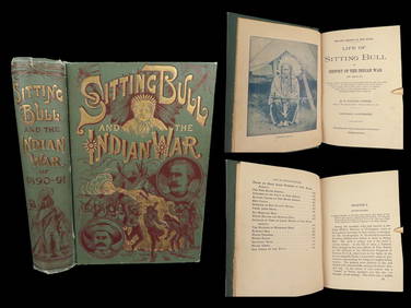
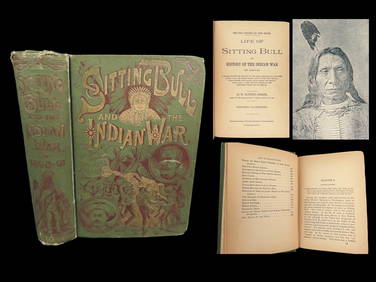
1891 Sitting Bull 1st ed Life Native American Sioux Indians DAKOTA Ghost DanceSchilb Antiquarian Rare Books4.8(421)See Sold PriceMar 10, 2024
Westland Oil Company North Dakota Road MapCheck the Oil Promotions, LLC4.6(275)See Sold PriceFeb 25, 2024
1891 DAKOTA Indians 1st ed Life Sitting Bull Native American Sioux Ghost DanceSchilb Antiquarian Rare Books4.8(421)See Sold PriceMar 31, 2024
Collection of Allied Military Silk Printed Maps, WWII Era and LaterMaterial Culture4.6(765)See Sold PriceFeb 29, 2024
North & West Africa. Dahomey. Gold Coast. Military Territory. THE TIMES 1922 mapJasper524.5(9.8k)See Sold PriceFeb 28, 2024
Vintage Dakota Territory Centennial ButtonRapid Estate Liquidators and Auction Gallery4.5(1.1k)See Sold PriceFeb 25, 2024
Francis McNally - Antique Map of Nebraska, Kansas, Dakota, Colorado & MontanaProverde Auctions4.3(3)See Sold PriceFeb 28, 2024
Robert H Labberton - Map of The Territory of the Present United States - The territory of theProverde Auctions4.3(3)See Sold PriceFeb 28, 2024
1921 USGS Topographic Map of North DakotaRapid Estate Liquidators and Auction Gallery4.5(1.1k)See Sold PriceFeb 27, 2024
The Kingdom of Dalmatia Territories Map, 1700Antiques Online Auctions4.6(407)See Sold PriceMar 14, 2024