SoldMap showing overland routes across U.S. 1860Title: Map of the Overland and Ocean North American Mail Routes. Corrected up to 1860 Author: Pemberton, J.D. Description: Lithographed map, hand-colored (later?). 53x38 cm. (16¾x14¾").Scarce map ofSee Sold Price
Map pertaining to Major E. Steen, U.S. Dragoons in 1860Dixon (Lieutenant, Topographical Engineers) Joseph. Map showing the routes traveled by the command of Major E. Steen, U.S. Dragoons against the Snake Indians in 1860. NY Lithography by Julius Bien, 18See Sold Price
SoldMap - Major Steen, US Dragoons Snake Indians 1860Map pertaining to Major E. Steen, U.S. Dragoons against Snake Indians 1860 - Dixon (Lieutenant, Topographical Engineers) Joseph. Map showing the routes travelled by the command of Major E. Steen, U.S.See Sold Price
SoldRoutes across the west 1855Heading: Author: Steptoe, E.J., Rufus Ingalls, et al. Title: Map showing the different routes travelled over by the Detachments of the Overland Command in the Spring of 1855 from Salt Lake City, UtahSee Sold Price
Map Showing the Routes Travelled by the Command of Maj.Map: Map Showing the Routes Travelled by the Command of Maj. E. Steen, U.S. Drags Against The Snake Indians in 1860... Publication Date: 1860 Cartographer: DIXON, JOSEPH (1834-1862) Publisher: WAR DEPSee Sold Price
SoldMap of U.S. & railroad lines 1875Heading: (Map - United States) Author: Title: New map of the American overland route, showing its connections, and land grants of 30,000,000 acres Place Published: Chicago Publisher:Rand, McNally & CSee Sold Price
Map pertaining to Major E. Steen, U.S. Dragoons againstDixon (Lieutenant, Topographical Engineers) Joseph. Map showing the routes travelled by the command of major E. Steen, U.S. Dragoons against the Snake Indians in 1860. NY Lithography by Julius Bien, 1See Sold Price
Map pertaining to Major E. Steen, U.S. Dragoons againstDixon (Lieutenant, Topographical Engineers) Joseph. Map showing the routes travelled by the command of major E. Steen, U.S. Dragoons against the Snake Indians in 1860. NY Lithography by Julius Bien, 1See Sold Price
SoldColton's pocket map of Western U.S. 1869Heading: Author: Colton, George Woolworth and Charles B. Colton Title: Colton's Map of the States and Territories West of the Mississippi River to the Pacific Ocean Showing the Overland Routes, ProjeSee Sold Price
Williams map of U.S. with inset of West 1854Heading: (United States) Author: Williams, W. Title: A New Map of the United States upon which are Delineated the Vast Works of Internal Communications, Routes across the Continent &c. Showing also CaSee Sold Price
Williams map of U.S. with inset of West 1854Title: A New Map of the United States upon which are Delineated the Vast Works of Internal Communications, Routes across the Continent &c. Showing also Canada and the Island of Cuba Author: Williams,See Sold Price
Williams map of U.S. with inset of West 1854Title: A New Map of the United States upon which are Delineated the Vast Works of Internal Communications, Routes across the Continent &c. Showing also Canada and the Island of Cuba Author: Williams,See Sold Price
SoldWilliams map of U.S. with inset of West 1854Title: A New Map of the United States upon which are Delineated the Vast Works of Internal Communications, Routes across the Continent &c. Showing also Canada and the Island of Cuba Author: Williams,See Sold Price
Williams map of U.S. with inset of West 1854Title: A New Map of the United States upon which are Delineated the Vast Works of Internal Communications, Routes across the Continent &c. Showing also Canada and the Island of Cuba Author: Williams,See Sold Price
SoldAAA map of routes across U.S., 1918Heading: (United States) Author: Title: General Map of Transcontinental Routes with Principal Connections Place Published: Washington/New York Publisher:American Automobile Association Date PublSee Sold Price
Sold(PICTORIAL MAP.) Bayle, Luc Marie. TAI - Transports(PICTORIAL MAP.) Bayle, Luc Marie. TAI - Transports Aeriens Intercontinentaux. Color-lithographed double-hemisphere pictorial world map showing flight routes of French airline TAI across the globe inSee Sold Price
SoldAfter G.Hanser, 19th century map of Deutschland,After G.Hanser, 19th century map of Deutschland, showing postal and train routes across Germany, engraving, circa 1848, H.75.5cm W.60cmSee Sold Price
SoldMap of Central Texas 1850Heading: Author: U.S. Government Title: Map Showing the Route of the Arkansas Regiment from Shreveport, La. to San Antonio de Bexar, Texas Place Published: Washington Publisher: Date Published:See Sold Price
SoldProposed railroad routes across U.S. 1848Heading: Author: Mills, Robert Title: Map of the Country between the Atlantic & Pacific Oceans [on sheet with] (World) Place Published: Washington Publisher: Date Published: 1848 DescrSee Sold Price
Proposed railroad routes across U.S. 1848Title: Map of the Country between the Atlantic & Pacific Oceans [on sheet with] (World) Author: Mills, Robert Description: Two lithographed maps on 1 sheet. 1st is 19.5x41.5 cm.; 2nd is 15.5x24 cm.A mSee Sold Price
Northern Route U.S. Mail Line and American Express LineTitle/Content of Map: Northern Route U.S. Mail Line and American Express Line Date: c1850 Cartographer: Size: 7.5X10.7 Map showing Lake Ontario & up state New York & Niagara Falls (also vignette). "RoSee Sold Price
Sold(Maps and Charts, United States), Colton, Joseph H(Maps and Charts, United States), Colton, Joseph H. (1800-1893), Map of the United States...showing the routes of the U.S. Mail Steam Packets to California, and a Plan of the Gold Region, New York, 18See Sold Price
1876 Colton Folding Map of the Western United States1876 Colton Folding Map of the Western United States -- Colton's Map of the States and Territories West of the Mississippi River to the Pacific Ocean Showing the Overland Routes, Projected Rail Road LSee Sold Price
Colton: Antique Map of the Western United States, 1876Map: 1876 Colton Folding Map of the Western United States -- Colton's Map of the States and Territories West of the Mississippi River to the Pacific Ocean Showing the Overland Routes, Projected Rail RSee Sold Price
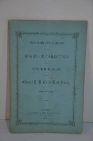
Central Railroad of New Jersey 13th Annual Report-January 1, 1860JM Hobby Supply and Railroad Artifact Auctions4.4(127)See Sold PriceFeb 24, 2024
Lake Superior and Mississippi River RR 1869 Seven Percent Bonds Book/Report-1869JM Hobby Supply and Railroad Artifact Auctions4.4(127)See Sold PriceFeb 24, 2024
Central Railroad of New Jersey Map of Sandy Hook Route-ca. 1903JM Hobby Supply and Railroad Artifact Auctions4.4(127)See Sold PriceFeb 24, 2024
Union Pacific RR Map of the United States-1926JM Hobby Supply and Railroad Artifact Auctions4.4(127)See Sold PriceFeb 24, 2024
Grand Trunk Railroad Across the Continent Through Canada Book-1917JM Hobby Supply and Railroad Artifact Auctions4.4(127)See Sold PriceFeb 24, 2024
Union Pacific RR Across The Continent West From Omaha, NE Book-April 2, 1868JM Hobby Supply and Railroad Artifact Auctions4.4(127)See Sold PriceFeb 24, 2024
Group of New York Central Railroad Paper - Rule Books, Employee Timetables, Stationary, Log Books,Rail & Road Auctions4.6(165)See Sold PriceMar 07, 2024
Map of Part of the West Indies, Etc., Showing the Exact Position Of The U.S. War Steamer SanJasper524.5(9.9k)See Sold PriceFeb 27, 2024
NORTHERN AFRICA. Morocco Tunisia Algeria. Caravan routes. RAPKIN/TALLIS 1851 mapJasper524.5(9.9k)See Sold PriceFeb 28, 2024
AFRICA. Shows Mountains of Kong/the Moon. Caravan routes. RAPKIN/TALLIS 1851 mapJasper524.5(9.9k)See Sold PriceFeb 28, 2024
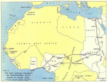
West Africa WW2 Nigeria Sudan Egypt. Takoradi air reinforcement route 1954 mapJasper524.5(9.9k)See Sold PriceFeb 28, 2024
WEST AFRICA showing early explorers' routes & Mountains of Kong. SDUK 1844 mapJasper524.5(9.9k)See Sold PriceFeb 28, 2024
NORTHERN AFRICA. Morocco Tunisia Algeria. Caravan routes.TALLIS/RAPKIN 1851 mapJasper524.5(9.9k)See Sold PriceFeb 28, 2024
NORTHERN AFRICA. Morocco Tunisia Algeria. Caravan routes. RAPKIN/TALLIS 1851 mapJasper524.5(9.9k)See Sold PriceFeb 28, 2024