Ducatus Wurtenbergici cum Locis limitaneis. Teilkol.Baden-Württemberg Ducatus Wurtenbergici cum Locis limitaneis. Teilkol. Kupferkarte nach J. Majer. Nürnberg, Homann, um 1710. Plattenmaße ca. 57 x 96,5 cm (65 x 98 cm). In 18 Segmenten auf Lwd. aufgSee Sold Price
Ducatus Wurtenbergici cum Locis limitaneis. Teilkol.Baden-Württemberg Ducatus Wurtenbergici cum Locis limitaneis. Teilkol. Kupferkarte nach J. Majer. Nürnberg Homann um 1710. Plattenmaße ca. 57 x 96 5 cm (65 x 98 cm). In 18 Segmenten aufSee Sold Price
SoldHOMANN, JOHANN BAPTIST 1664 Oberkammlach - NürnbergHOMANN, JOHANN BAPTIST 1664 Oberkammlach - Nürnberg 1724 Ducatus Würtenbergici cum locis limitaneis (...) Kupferstich, handkoloriert, Druckmaß 56 cm x 94 cm, oben rechts in der Legende bez., MittelSee Sold Price
MAP, Southwestern Germany, HomannSouthwestern Germany. Johann Baptist Homann, [On 2 Sheets] Ducatus Wurtenbergici cum Locis Limitaneis, Utpote Maxima Parte Circuli Suevici..., from Neuer Atlas uber die Gantze Welt, 1716 (circa). HandSee Sold Price
SoldM.J. Mayer "Ducatus Wurtenbergici cum ... CirculiM.J. Mayer "Ducatus Wurtenbergici cum ... Circuli Suevici ... Marchionatu Badnsi et Sylva vulgo Nigra." 1710. Two coloured copper cards. Printed by J.B. Homann. Two cartridges with views of german citSee Sold Price
Lotter, Conrad Tobias. Comitatus Namurcensis cum locisLotter, Conrad Tobias Comitatus Namurcensis cum locis É C. 1770 Copperplate engraving; outline coloured Printed area: 48.8 x 57.5 cm; 19.2 x 22.6 in A map of the County of Namur centered on the CitySee Sold Price
Westphalia Ducatus. Teilkol. Kupferstichkarte von J.M.Partly col. copper engr. map. - Centrefold with small backed tear, vertical wrinkle, French text on verso, white margins partly stained, otherwise fine. Westphalia Ducatus. Teilkol. Kupferstichkarte vSee Sold Price
Sold[Lituania][Lituania]. Vijukas-Kojalavicius, Albertas. Historiae lituanae a conjunctione magni ducatus cum regno Poloniae ad unionem eorum dominiorum, libri octo. Anversa, Meursius, 1669. In 4° (215 x 160 mm);See Sold Price
Antique Map of Glocestershire & Monmouthshire, c.1680sMap of Glocestershire & Monmouthshire by Gerard Valck (1651-1726) & Pieter Schenk (1660-1711) of Amsterdam, between 1670 and 1690. Glocestria Ducatus cum Monumethensi Comitatu. Amstelaedami (AmsterdaSee Sold Price
Antique Map of Glocestershire & Monmouthshire, c.1680sMap of Glocestershire & Monmouthshire by Gerard Valck (1651-1726) & Pieter Schenk (1660-1711) of Amsterdam, between 1670 and 1690. Title. Glocestria Ducatus cum Monumethensi Comitatu. Amstelaedami (ASee Sold Price
Antique Map of Glocestershire & Monmouthshire, c.1680sMap of Glocestershire & Monmouthshire by Gerard Valck (1651-1726) & Pieter Schenk (1660-1711) of Amsterdam, between 1670 and 1690. Title. Glocestria Ducatus cum Monumethensi Comitatu. Amstelaedami (ASee Sold Price
SoldMap of Jerusalem. Braun & Hogenberg. Koln, 1593.Ierusalem, et Suburbia eius, sicut Tempore Christi Floruit, cum Locis in quibus Christ Passus ... Descripta per Christianum Adrichom Delphum. Imaginary map of Jerusalem and its suburbs, from Jesus's eSee Sold Price
Map Gulf of Finland Cronstadt Petersburg SeutterMap of the Gulf of Finland from Cronstadt to St Petersburg with depiction of surrounding Summer Palaces. Accurata Delineatio Sinus Finnisi Cronstadio Petropolin usque, una cum locis amoenis in litoreSee Sold Price
SoldJOANNES JANSSON GLOUCESTERSHIREJoannes Jansson Glocestria Ducatus, cum Monumethensi Comitatu Glocester Shire & Monmouth Shire, hand coloured map, with good margins, a good impression 41 x 51cmSee Sold Price
Antique Map of Glocestershire & Monmouthshire, c.1680sMap of Glocestershire & Monmouthshire by Gerard Valck (1651-1726) & Pieter Schenk (1660-1711) of Amsterdam, between 1670 and 1690. Title. Glocestria Ducatus cum Monumethensi Comitatu. Amstelaedami (ASee Sold Price
SoldG VALK AND P SCHENKG Valk and P Schenk A map of Gloucestershire and Monmouthshire; Glocestria Ducatus cum Monumethensi, hand coloured engraved map, a good impression 41 x 50.5cmSee Sold Price
Antique Map of Glocestershire & Monmouthshire, c.1680sMap of Glocestershire & Monmouthshire by Gerard Valck (1651-1726) & Pieter Schenk (1660-1711) of Amsterdam, between 1670 and 1690. Glocestria Ducatus cum Monumethensi Comitatu. Amstelaedami (AmsterdaSee Sold Price
SoldComitatus Namur Censis Carte MapComitatus Namur Censis cum locis Ejusdem munitio ribus ac regionib. [...] Augsbourg, s. d. [XVIIIe]. 490 x 580 mm Carte rehaussée. Trace de pli central.See Sold Price
Antique Map of Glocestershire & Monmouthshire, c.1680sMap of Glocestershire & Monmouthshire by Gerard Valck (1651-1726) & Pieter Schenk (1660-1711) of Amsterdam, between 1670 and 1690. Glocestria Ducatus cum Monumethensi Comitatu. Amstelaedami (AmsterdaSee Sold Price
1588 Braun and Hogenberg View of Jerusalem (Partial) -- Ierusalem, et Suburbia Eius, Sicut TemporeTitle: 1588 Braun and Hogenberg View of Jerusalem (Partial) -- Ierusalem, et Suburbia Eius, Sicut Tempore Christi Floruit, cum Locis, in Quibus Christus Passus Cartographer: Braun and Hogenberg Year /See Sold Price
MAP, Jerusalem, Holy Land, AdrichomFirst Edition of Adrichom's Influential Bird's-Eye Plan of Jerusalem. Jerusalem, Holy Land. Christian van Adrichom, Ierusalem I., et Suburbia eius, Sicut Tempore Christi Floruit, cum Locis, in QuibusSee Sold Price
T. Conrad Lotter "Artesia cum finitimis locis velT. Conrad Lotter "Artesia cum finitimis locis velut Sedes Ac Theatrum Belli ...". Ca. 1730. Coloured engraving after Guillaume de L'Isle. With decorative cartridge to the upper right with allegories oSee Sold Price
1730 Seutter Map of Northwest France -- Artesia cum Finitimis Locis Velut Sedes ac Theatrum Belli …Title: 1730 Seutter Map of Northwest France -- Artesia cum Finitimis Locis Velut Sedes ac Theatrum Belli … Cartographer: M Seutter Year / Place: 1730, Augsburg Map Dimension (in.): 19.3 X 22.8 in. TSee Sold Price
1730 Seutter Map of Northwest France -- Artesia cum Finitimis Locis Velut Sedes ac Theatrum BelliTitle: 1730 Seutter Map of Northwest France -- Artesia cum Finitimis Locis Velut Sedes ac Theatrum Belli … Cartographer: M Seutter Date/Place: 1730, Augsburg Dimensions: 19.3 X 22.8 in. DescriptSee Sold Price
EARLY 18TH C. DUTCH CHART OF PACIFIC OCEAN BY FREDERIK DE WIT (1629-1706) WITH CALIFORNIA AS ANThomaston Place Auction Galleries4.4(386)See Sold PriceFeb 24, 2024
NICOLAES VISSCHER (NETHERLANDS, 1618-1709) MAP OF THE NEW WORLDThomaston Place Auction Galleries4.4(386)See Sold PriceFeb 24, 2024
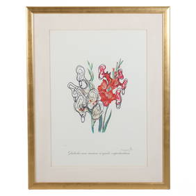
Salvador Dali 20C. GLADIOLI Relief EA Litho SIGNEDHill Auction Gallery 4.7(1k)See Sold PriceFeb 28, 2024
Willem Blaeu, Etc. 17th C. Antiquarian Maps, 2Auctions at Showplace4.5(726)See Sold PriceMar 17, 2024
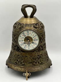
QUIET RIOT CUM ON FEEL THE NOIZE 4 SIGS JSA/COA SIGNED 8X10 PHOTO SHEET MUSICMynt Auctions4.6(680)See Sold PriceFeb 23, 2024
De Jode, Rare, pub. 1593 - Map of Luxembourg (Lutzenburgii montuosissimi ac saltuosissimi ducatusTrillium Antique Prints & Rare Books4.5(30)See Sold PriceFeb 24, 2024
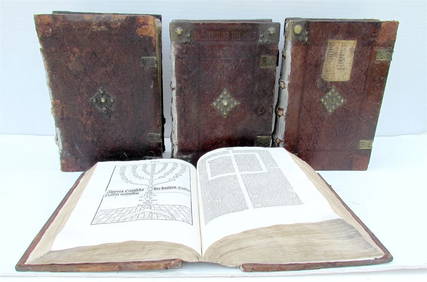
1485 INCUNABLE BIBLE 4 volumes INCUNABULA ILLUSTRATED BIBLIA LATINA antique 15 cJasper524.5(9.8k)See Sold PriceFeb 27, 2024
1660 Valerius Maximus Cum Selectis Observati ANTIQUE VELLUM BINDINGJasper524.5(9.8k)See Sold PriceFeb 27, 2024
1591 MEDICAL TREATISE De miraculis occultis naturæ antique by L. Lemnius pigskinJasper524.5(9.8k)See Sold PriceFeb 27, 2024
1751 PIGSKIN BINDING BIBLE BIBLIA SACRA FOLIO 9.5 x 15" antique ILLUSTRATEDJasper524.5(9.8k)See Sold PriceFeb 27, 2024
Library catalogues.- Bibles.- Ittig (Thomas) Bibliotheca Ittigiana, cum indice alphabetico, cujusForum Auctions4.3(52)See Sold PriceFeb 29, 2024
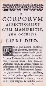
Medicine.- Du Hamel (Jean Baptiste) De Corporum Affectionibus cum Manifestis, tum Occultis, firstForum Auctions4.3(52)See Sold PriceFeb 29, 2024
ANCIENT AFRICA cum Aegypto et Insulis. Nigritae Aethiopia. ARROWSMITH 1828 mapJasper524.5(9.8k)See Sold PriceFeb 28, 2024
1660 ANTIQUE VELLUM BINDING VALERIUS MAXIMUS CUM SELECTIS OBSERVATINY Elizabeth 4.3(84)See Sold PriceMar 03, 2024
16TH AND 17TH CENTURY MEDICAL WORKS. A group of early publications on medicine and surgery.Bonhams4.1(305)See Sold PriceJun 18, 2024


![[Lituania] (1 of 1)](https://p1.liveauctioneers.com/5687/97246/49587536_1_x.jpg?height=282&quality=70&version=1480679548)