Incredible Named WW2 WWII Luftwaffe Generals German Desk Flag Paperweight with Presentation boxEagles Corps International LLC4.6(107)See Sold PriceMar 10, 2024
Bronze Inkwell Stamped Tiffany Studios New York Age And Authenticity UnknownRbfinearts4.4(571)See Sold PriceFeb 24, 2024
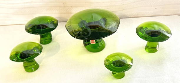
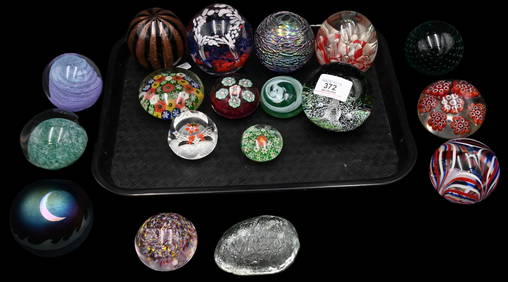
Group of Nine Early Signed Glass PaperweightsNadeau's Auction Gallery4.7(401)See Sold PriceFeb 24, 2024
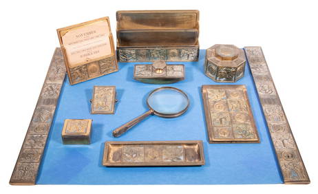
(10 PC) TIFFANY BRONZE DESK SET "BOOKMARK" PATTERNThomaston Place Auction Galleries4.4(386)See Sold PriceFeb 25, 2024
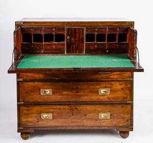
BRASS BOUND MAHOGANY FALL FRONT CAMPAGNE DESKJohn McInnis Auctioneers,LLC4.6(502)See Sold PriceFeb 25, 2024
Chinese Blue White Porcelain Brush PotChina Luban Art & Antique, Inc.4.4(78)See Sold PriceFeb 24, 2024
Vintage Chinese 5 Toe Dragon Bat Carved Resin Figural Bowl 6.25 Inches Wide 1.4lbsHess Fine Auctions4.5(197)See Sold PriceMar 02, 2024
1930s CARVED & PAINTED WOOD SCOTTIE DOG PEN RESTJohn McInnis Auctioneers,LLC4.6(502)See Sold PriceFeb 25, 2024
Sold'Carte Itineraire de L'Europe,'' 1848''Carte Itineraire de L'Europe,'' 1848, Paris: Longuet Succ de Simoneau, divided into (4) folding quadrants. Losses to case, linen backed, toning, minor image bleeding, minor foxing. Each map 19-3-/4'See Sold Price
SoldA.H. Dufour 1847 Folding Map of Europe"Carte Itineraire de L'Europe". 1847 Paris Longuet, Succ. de Simonneau". Cloth backed. 37 x 50 inches Condition: Good.See Sold Price
Carte Politique Et Itineraire De L'Europe...1807 map of Europe: “CARTE POLITIQUE ET ITINÉRAIRE DE L'EUROPE ET DE L'EMPIRE FRANCAIS EN 1807 “by Hyacinthe Langlois. Measurement approximate: 19” x 14.5”. Please note that this lot has a coSee Sold Price
SoldFrench Lithographic Map of 1807 EuropeFrench lithographic map of 1807 Europe, coat of arms and title to the upper left corner reads in French ‘Carte politburo et itineraire de L’Europe et du L’Empire Francais en 1807’, legend to lSee Sold Price
Carte Politique De L'Europe Et De L'Empire FrancaisMap: Carte Politique Et Itineraire De L'europe Et De L'empire Francais en 1807 Maker: Hyacinthe Langlois Material: Wooden frame Date: Late 1800's, early 1900's Size: 19 x 14.25 inches Please note thatSee Sold Price
SoldHyacinthe Langlois: Carte Politique De L'europe, 18071807 map of Europe: “Carte Politique Et Itinéraire De L'europe Et De L'empire Francais en 1807 “by Hyacinthe Langlois. Engraved By: D. Derveaux. Measurement approximate: 19” x 14.5”. Please nSee Sold Price
SoldHand Colored Map of Europe, Early 19th C19th Century hand clored Map “Carte Politique et Itineraire de L’Europe et de L’Empire Francais en 1807”. By Chex Hyacinethe Langlois, Libraire, engraved by D. Derveaux, del. On laid paper. NoSee Sold Price
Hand Colored Map of Europe, Early 19th C19th Century hand clored Map "Carte Politique et Itineraire de L'Europe et de L'Empire Francais en 1807". By Chex Hyacinethe Langlois, Libraire, engraved by D. Derveaux, del. On laid paper. Not examinSee Sold Price
SoldEurope.- Traux (Maximilian de) Carte Generale etEurope.- Traux (Maximilian de) Carte Generale et Itineraire de L'Europe Divisee en tous ses Etats apres Le Congres de Vienne, large folding map of Europe, with large calligraphic title in the upper leSee Sold Price
Sold[Map/Europe]. Grande Carte De L'Europe. Turin[Map/Europe]. Grande Carte De L'Europe. Turin: 1852. Sectional map of Europe in 9 sheets, incomplete. Each sheet about 13 1/4 x 16 3/4 inches, some areas colored. Should be seen.See Sold Price
Lapie: Carte de l'Europe, 1833Carte de l'Europe. The highly detailed Europe map from the first edition of Lapie's influential Atlas Universel. Adorned by an elegant title cartouche, the superbly engraved map encompasses the entireSee Sold Price
SoldCarte de l'Europe"Carte de l'Europe Suivant Les Plus Nouvelles Observations de Messieurs de L'Academic des Sciences Et des Princi...", hand-colored engraved map of Europe from Henri Chatelain, Atlas Historique, LondonSee Sold Price
SoldPierre Lapie (1779-1850), "Carte De L'Europe sousPierre Lapie (1779-1850), "Carte De L'Europe sous Charlemagne and sous Charles-Quint," 1831; "Carte De Europe en 1789 and en 1813," 1831; and "Carte De L'Europe Avant L'Invasion Des Barbares, and ApreSee Sold Price
Sold Carte de l'Europe suivant les plus Nouvelles ObservatCarte de l'Europe suivant les plus Nouvelles Observations de Messieurs de l'Academie des Sciences et des Principaux Geographes avec des Tables et de Nouvelles Instructions ... Kupferstichkarte aus ChaSee Sold Price
SoldChatelain (Henri Abraham) Carte De L'Europe SuivanChatelain (Henri Abraham) Carte de l'Europe suivant les plus nouvelles Observationsde Messieurs de L'Academie des Sciences..., hand-coloured engraved map, 480 x 600mm, [c.1720] § Bowen (EmanueSee Sold Price
Carte de L'Europe. Map of Europe. MALTE-BRUN c1871 oldTITLE/CONTENT OF MAP: 'Carte de l'Europe [Map of Europe]' DATE PRINTED: c1871 IMAGE SIZE: Approx 33.5 x 46.5cm, 13.25 x 18.25 inches (Large); Please note that this is a folding map. TYPE: Antique 19thSee Sold Price
SoldPierre Lapie (1779-1850), "Carte De L'Europe sousPierre Lapie (1779-1850), "Carte De L'Europe sous Charlemagne and sous Charles-Quint," 1831; "Carte De Europe en 1789 and en 1813," 1831; and "Carte De L'Europe Avant L'Invasion Des Barbares, and ApreSee Sold Price
Carte de L'Europe. Map of Europe. MALTE-BRUN c1871 old antique plan chartTITLE/CONTENT OF MAP: 'Carte de l'Europe [Map of Europe]' DATE PRINTED: c1871 IMAGE SIZE: Approx 33.5 x 46.5cm, 13.25 x 18.25 inches (Large); Please note that this is a folding map. TYPE: Antique 19thSee Sold Price
Carte De L'europeTitle: Carte De L'europe Publication Date: c1820 Cartographer: ANONYMOUS. FRENCH Publisher: Dimension: 7.25Height - 8.6Width Anonymous geography map, about 1820, although still struck on laid paper. VSee Sold Price
1930 Grande Carte de L'Europe CentraleA 1930 Map of Central Europe, designed and printed for bicycling and automotive routes. Large folding map.See Sold Price
Lapie: Carte de l'Europe, 1833Map: Carte de l'Europe Cartographer: Lapie Place & Date: Paris / 1833 Size: 21 1/2" x 15 7/8" Condition: outline color; light overall age toning and minor spotting, mostly in margins; repaired split iSee Sold Price
Carte De L'europeReserve Reduced! Title: Carte De L'europe Publication Date: c1820 Cartographer: ANONYMOUS. FRENCH Publisher: Size: 7.25X8.6 Anonymous geography map, about 1820, although still struck on laid paper. VaSee Sold Price
Carte De L'europePublication Date: c1820 Title: Carte De L'europe Cartographer: ANONYMOUS. FRENCH Height: 7.25 Width: 8.6 Anonymous geography map, about 1820, although still struck on laid paper. Vague national boundaSee Sold Price
Carte de L'Europe. Map of Europe. MALTE-BRUN c1871 old antique plan chartTITLE/CONTENT OF MAP: 'Scandinavia, or Sweden, Denmark and Norway' DATE PRINTED: 1830 IMAGE SIZE: Approx 60.5 x 51.0cm, 23.75 x 20 inches (Large); Please note that this is a folding map. TYPE: AntiqueSee Sold Price
Van Houtte - Lady's Slipper OrchidTrillium Antique Prints & Rare Books4.5(30)See Sold PriceFeb 24, 2024
Railways & Transport.- [Prospectus] The Dorking, Brighton, and Arundel Atmospheric Railway, byForum Auctions4.3(52)See Sold PriceFeb 29, 2024
Van Houtte (Pub) C1860 Pair of Folio Greenhouse Prints. BelgiumAlbion Auctions4.6(336)See Sold PriceMar 07, 2024
1764 Bellin Map of Mari-Galante Near Guadeloupe -- Carte de l'Isle de Mari-GalanteJasper524.5(9.8k)See Sold PriceFeb 27, 2024
1764 Bellin Map of St. Kitts -- Carte de l'Isle St. ChristopheJasper524.5(9.8k)See Sold PriceFeb 27, 2024
1764 Bellin Map of Antigua -- Carte de l'Isle d'Antigue Situee par la Latitude 17 Degres et par laJasper524.5(9.8k)See Sold PriceFeb 27, 2024
1845 Delisle/Bauche Map of Martinique -- Carte de l'Isle de la Martinique Colonie Francoise de l'uneJasper524.5(9.8k)See Sold PriceFeb 27, 2024
DORE GUSTAVE: (1832-1883)International Autograph Auctions Europe S.L.4.5(52)See Sold PriceMar 14, 2024
CAILLEBOTTE GUSTAVE: (1848-1894)International Autograph Auctions Europe S.L.4.5(52)See Sold PriceMar 14, 2024
GAUGUIN PAUL: (1848-1903)International Autograph Auctions Europe S.L.4.5(52)See Sold PriceMar 14, 2024
GAUGUIN PAUL: (1848-1903)International Autograph Auctions Europe S.L.4.5(52)See Sold PriceMar 14, 2024
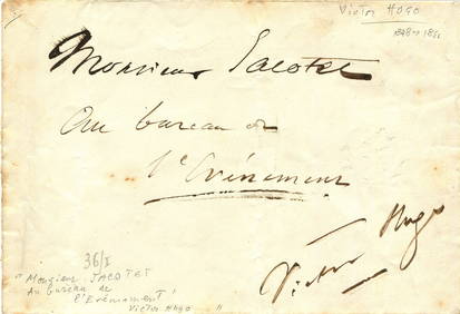
HUGO VICTOR: (1802-1885)International Autograph Auctions Europe S.L.4.5(52)See Sold PriceMar 14, 2024
HUGO VICTOR: (1802-1885)International Autograph Auctions Europe S.L.4.5(52)See Sold PriceMar 14, 2024
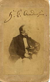
ANDERSEN HANS CHRISTIAN: (1805-1875)International Autograph Auctions Europe S.L.4.5(52)See Sold PriceMar 14, 2024
NAPOLEON III: (1808-1873)International Autograph Auctions Europe S.L.4.5(52)See Sold PriceMar 14, 2024
WILHELM KARL: (1864-1928)International Autograph Auctions Europe S.L.4.5(52)See Sold PriceMar 14, 2024
[ALEXANDER III]: (1845-1894)International Autograph Auctions Europe S.L.4.5(52)See Sold PriceMar 14, 2024
1939 A La Conquete De L'europe Softcover BookRapid Estate Liquidators and Auction Gallery4.5(1.1k)See Sold PriceFeb 27, 2024


![[Map/Europe]. Grande Carte De L'Europe. Turin (1 of 0)](https://p1.liveauctioneers.com/dist/images/placeholder.jpg?height=282&quality=70)


![Railways & Transport.- [Prospectus] The Dorking, Brighton, and Arundel Atmospheric Railway, by (1 of 1)](https://p1.liveauctioneers.com/5458/319736/171654703_1_x.jpg?height=282&quality=70&version=1708010439)


![[ALEXANDER III]: (1845-1894) (1 of 2)](https://p1.liveauctioneers.com/1458/320148/172030958_1_x.jpg?height=282&quality=70&version=1708367366)
