Gothic Revival Stained Glass Window of The ResurrectionSchmidt's Antiques Inc. Since 19114.8(440)See Sold PriceMar 02, 2024
THE FITZGERALD FAMILY TEA and DINNER SERVICEJohn McInnis Auctioneers,LLC4.5(505)See Sold PriceFeb 25, 2024
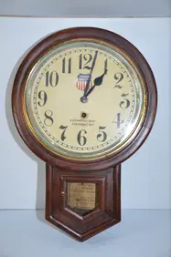
Union Pacific RR Cheyenne, WY Locomotive Shop ClockJM Hobby Supply and Railroad Artifact Auctions4.4(127)See Sold PriceFeb 24, 2024
A CHINESE PORCELAIN GREEN ENAMELED DRAGON MOON FLASK BIANHUBerkeley Auction Gallery4.4(16)See Sold PriceMar 03, 2024
Antique George III Musical Bracket Clock by Hare LondonHill Auction Gallery 4.7(1k)See Sold PriceFeb 28, 2024
No Reserve Early 20th century French / Flemish Design Tapestry 6 ft 2 in x 4 ft 9 in (1.87 m x 1.44Nazmiyal Auctions4.4(36)See Sold PriceFeb 25, 2024
Central Anatolia Konya Antique Rug 4 ft 8 in x 3 ft 8 in (1.42 m x 1.11 m)Nazmiyal Auctions4.4(36)See Sold PriceFeb 25, 2024
PAIR MAGNIFICENT AND LARGE CLOISONNE ENAMEL CRANES INCENSE BURNERSBerkeley Auction Gallery4.4(16)See Sold PriceMar 03, 2024
From Davide Halevim Collection Antique Persian Mohtashem Kashan Rug 10'11" x 7'10" (3.32 m x 2.38 m)Nazmiyal Auctions4.4(36)See Sold PriceFeb 25, 2024
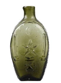
RARE COVENTRY GLASS WORKS MASONIC FLASKJohn McInnis Auctioneers,LLC4.5(505)See Sold PriceFeb 25, 2024
Empire by Buccellati Italy Sterling Silver Flatware Set 99 pieces DinnerBidhaus4.3(773)See Sold PriceFeb 25, 2024
Sold(BLUEBACK CHART.) Norie, J.W. A General Chart of the(BLUEBACK CHART.) Norie, J.W. A General Chart of the Mediterranean, Adriatic and Black Seas; Together with the Grecian Archipelago. Large engraved nautical chart on 4 sheets joined. 32x82½ inchesSee Sold Price
SoldSTEEL'S NEW AND ACCURATE CHART Blueback chart of theSTEEL'S NEW AND ACCURATE CHART Blueback chart of the southern part of the North Sea comprehending the eastern coast of England from Dungeness to Lynn Deeps. By J.W. Norie, Hydrographer. Last date on cSee Sold Price
SoldJOHN WILLIAM NORIE (1772-1843) BLUE BACK NAUTICAL CHART"A New Chart of the West Coast of South America from Truxillo to Panama, including the Galapagos Islands and Plans of the Principal Harbors". Drawn from the Best Spanish Surveys by J.W. Norie, HydrogrSee Sold Price
SoldNorie (J.W.) Chart of the Coast of ChinaNorie (J.W.) A New Chart of the Coast of China,from Pedra Branca to St John's Island, Exhibiting the Entrance to, and Course of, The River Tigris,decorative title medallion, the Hong Kong justSee Sold Price
SoldOriginal J.W. Norie Chart of the Black Sea, c.1854Original J.W. Norie chart of the Black Sea, with seas of Marmara and Azov, circa 1854. Spectacular chart of the Black Sea showing, Crimea, Sea of Azov, Black Sea, Grecian Archipelago, Bulgaria, BessarSee Sold Price
Original J.W. Norie Chart of Bay of Biscay, c.1855Original J.W. Norie chart of the Bay of Biscay, circa 1855. Chart shows the Atlantic Ocean and coast of France. Details about coast include Bordeaux, Rochfort, Nantes, Bay of Brest, Brest, and many moSee Sold Price
1841 J.W. Norie chart of EnglandOriginal nineteenth century chart of the east coast of England from Dungenels to Flamborough including the entrances to the Thames. As drawn from the latest surveys by J.W. Norie, Hydrographer. ShowinSee Sold Price
Sold1841 J.W. Norie chart of EnglandOriginal nineteenth century chart of the east coast of England from Dungenels to Flamborough including the entrances to the Thames. As drawn from the latest surveys by J.W. Norie, Hydrographer. ShowinSee Sold Price
1841 J.W. Norie chart of EnglandOriginal nineteenth century chart of the east coast of England from Dungenels to Flamborough including the entrances to the Thames. As drawn from the latest surveys by J.W. Norie, Hydrographer. ShowinSee Sold Price
Original J.W. Norie Chart of Bay of Biscay, c. 1855Original J.W. Norie chart of the Bay of Biscay, circa 1855. Chart shows the Atlantic Ocean and coast of France. Details about coast include Bordeaux, Rochfort, Nantes, Bay of Brest, Brest, and many moSee Sold Price
East Coast of England Chart, 1841JW Norie chart of the east coast of England from Dungenels 38 x 78See Sold Price
East Coast of England Chart, 1841JW Norie chart of the east coast of England from Dungenels. Overall Dimensions: 38" x 78"See Sold Price
SoldEast Coast of England Chart, 1841JW Norie chart of the east coast of England from Dungenels. Overall Dimensions: 38" H x 78" L Weight: 32lbs.See Sold Price
SoldEast Coast of England Chart, 1841JW Norie chart of the east coast of England from Dungenels 38 x 78See Sold Price
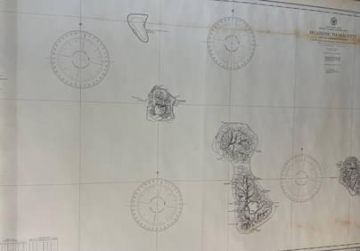
Sold19th century chart of the Orkney Islands.Early JW Norie chart dated 1826 entitled "Heather's New and Improved Chart of the Orkney Isles, drawn from the most approved surveys." Chart shows this group of islands just above the north coast of SSee Sold Price
SoldOriginal Chart from 1838 by JW Norie HydrographyOriginal 1838 chart of the Mediterranean including the Adriatic and Black Seas together with the Grecian Archipelago. Constructed principally from the surveys for J.W. Norie. The chart shows extensiveSee Sold Price
SoldAPPROX. THIRTEEN CHARTS AND TWO GREEN CANVAS SAIL BAGSAPPROX. THIRTEEN CHARTS AND TWO GREEN CANVAS SAIL BAGS19th CenturyIncludes eleven blueback charts. Majority in poor condition. Includes 1830 Norie chart of Italy, C. Wilson “North Sea”, W. JewettSee Sold Price
SoldTWO BLUEBACK CHARTS PUBLISHED BY RICHARD H. LAURIE,TWO BLUEBACK CHARTS PUBLISHED BY RICHARD H. LAURIE, LONDON 1) "A General Chart of the Coasts of Brasil, &c. From the River Para to Buenos Ayres ...". Circa 1842. 38.5" x 77". 2) "The Southern Part ofSee Sold Price
TWO BLUEBACK CHARTS PUBLISHED BY RICHARD H. LAURIE,TWO BLUEBACK CHARTS PUBLISHED BY RICHARD H. LAURIE, LONDON 1) "A General Chart of the Coasts of Brasil, &c. From the River Para to Buenos Ayres ...". Circa 1842. 38.5" x 77". 2) "The Southern Part ofSee Sold Price
TWO BLUEBACK CHARTS PUBLISHED BY RICHARD H. LAURIE,TWO BLUEBACK CHARTS PUBLISHED BY RICHARD H. LAURIE, LONDON 1) "A General Chart of the Coasts of Brasil, &c. From the River Para to Buenos Ayres ...". Circa 1842. 38.5" x 77". 2) "The Southern Part ofSee Sold Price
Map of "The Mediterranean, Adriatic and Black Seas ...A very large rolled nautical chart / map by famous British Hydrographer and Chart Maker John William Norie (1772 in London – 1843) | Chart titled: “A General Chart of THE MEDITERRANEAN, Adriatic aSee Sold Price
SoldNorie (J.W.) The Gulf of PersiaNorie (J.W.) The Gulf of Persia,coastal chart with rhum lines, coastal recognition views, and 5 inset charts of bays and islands, including Muscat and the mouth of the Euphrates, engraved charSee Sold Price
Blue-back chart of east coast of U.S. 1852Heading: Author: Norie, John William Title: To the Independent Mariners of America, This Chart of their Coast from Savannah to Boston is most Respectfully Dedicated… Place Published: London PublishSee Sold Price
Sold(Maps and Charts), Navigational Charts, Group of e(Maps and Charts), Navigational Charts, Group of eleven navigational charts, English and Spanish, by Robert Blachford, J.W. Norie, Taber & Blunt, and others, depicting various regions including NewfouSee Sold Price
CHART "LONG ISLAND SOUND FROM NEW YORK TO MONTOCK POINT ..." New York, 1830 21" x 77" sight. FramedEldred's4.7(423)See Sold PriceFeb 27, 2024
CHART "SOUTHERN COAST OF LONG ISLAND FROM MONTAUK POINT TO EAST HAMPTON" Circa 1877 11.25" x 22.75"Eldred's4.7(423)See Sold PriceFeb 27, 2024
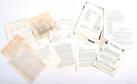
AUCHINCLOSS BURR JENNINGS FAMILY HISTORYJohn McInnis Auctioneers,LLC4.5(505)See Sold PriceFeb 25, 2024
Vtg Grow Up Illustr Chart Functional Design Inc 1940The Benefit Shop Foundation Inc.4.3(3k)See Sold PriceFeb 28, 2024
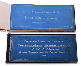
Chicago & Eastern Illinois Railroad 1901 Coal Mine Track and 1896 Brazil Division Track Chart BooksRail & Road Auctions4.6(165)See Sold PriceMar 08, 2024
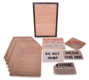
32 Railroad Loading Charts and Explosive Placards - Monon, Illinois Central, Northern Pacific, etc.Rail & Road Auctions4.6(165)See Sold PriceMar 08, 2024
Nystrom 20C. Antique Illustrated Anatomical ChartsHill Auction Gallery 4.7(1k)See Sold PriceFeb 28, 2024
Carey, pub. 1796 - A Chart of the West IndiesTrillium Antique Prints & Rare Books4.5(33)See Sold PriceFeb 24, 2024
1816 MAP SOUTHERN PART OF RUSSIA or MUSCOVY in EUROPE copper engraving ANTIQUEJasper524.5(9.9k)See Sold PriceFeb 27, 2024
VINTAGE LEATHER DOCTORS BAG & HUMAN SKELETON CHARTCarlsen Gallery, Inc.4.6(165)See Sold PriceMar 03, 2024
Anatomical Charts, AJ Nystrom 1918-1922State Line Auctions & Estate Services4.6(281)See Sold PriceFeb 25, 2024
Windward Islands and Spanish Main from the Latest Surveys 1860Jasper524.5(9.9k)See Sold PriceFeb 27, 2024
CHARTS: United States - East Coast New Jersey/ PASSAIC AND HACKENSACK RIVERSChurchill Galleries3.7(217)See Sold PriceFeb 26, 2024
CHART: South Pacific Ocean / SOCIETY ISLANDS - WESTERN GROUP/ HUAHINE TO MAUPITI With theChurchill Galleries3.7(217)See Sold PriceFeb 26, 2024
CHART: UNITED STATES - EAST COAST NEW YORK/ HUDSON RIVER/ POUGHKEEPSIE TO HUDSONChurchill Galleries3.7(217)See Sold PriceFeb 26, 2024