SoldMaclot, J. C.: Atlas général méthodiqueMaclot, (J. C.). Atlas général méthodique et élémentaire, pour l'étude de la géographie et de l'histoire moderne. 1 typogr. Titel, doppelblattgr. Kupferstich-Titel sowie 66 doppelblattgSee Sold Price
A Colored Engraved Map of Scotland by J.H. Colton, c.A Colored Engraved Map of Scotland by J.H. Colton, c. 1855, Engraved from a General Atlas. H: 16 W: 13 in.See Sold Price
Sold(MAP) PALAIRET, JEAN. A group of 2 hand-colored maps(MAP) PALAIRET, JEAN Two engraved maps with hand-coloring from Atlas methodique, by J. Palairet, (London, c. 1755), comprising Ie. Carte de l'Europe, 1754, and Ie. Carte des sept provinces unies desSee Sold Price
SoldRussell Map of the World Hand-Colored Engraving ca 1815J.C. Russell "Map of the World", London, ca. 1815 CE. A world map with striking engraving and hand-coloring, probably from "Russell's General Atlas of Modern Geography. Composed from the Latest & BestSee Sold Price
Sold[JOHN THOMPSON'S A NEW GENERAL ATLAS] 45 Maps[Collection of 45 maps] for John Thompson's A New General Atlas. Edinburgh, 1821. Approx. Approx. 53.8 x 70.8 cm (21.25" x 27.25"). Including:Arabia, Egypt, Abyssinia, Red Sea, &C. J. & G. Menzies FcuSee Sold Price
MACLOT, Jean Charles (1728-1805). Atlas generalmethodique et elementaire, pour l'etude de la geographie et de l'histoire moderne adapte a toutes les geographies. Paris: Desnos, 1770. Beautiful atlas with contemporary colouring, produced for the yoSee Sold Price
SoldMixed group of Middle East mapsMenzies (J. & G.) Arabia, Egypt, Abyssynia, Red Sea &c.,for Thomson's New General Atlas, engraved map with original hand-colouring in outline, 535 x 635mm., central vertical fold, 1814; with aSee Sold Price
SoldWILLIAMS, C. S.; and [MELISH, J. G.] A New GenWILLIAMS, C. S.; and [MELISH, J. G.] A New General Atlas. Engraved title, 40 hand-colored engraved maps. 4to, 295x240 mm, modern calf; maps quite bright and clean. New Haven: C. S. Williams, 1832 ContSee Sold Price
Scottish Engraved Map of the West-Indies, c. 1815Scottish Engraved Map of the West-Indies, c. 1815, drawn by J. & G. Menzies and printed to accompany Thomson's New General Atlas, entitled "Virgin Islands and Porto Rico, Haiti and St. Domingo", in twSee Sold Price
Russia in Europe Part X, General Map, 1840Map of Russia in Europe Part X, General Map. Society For The Diffusion Of Useful Knowledge/SDUK, Walker, J. & C. 1840-08-01. Extends east to the Ural Mountains. Quarto – 15.50 H x 12.25 W Inches PleSee Sold Price
Landscape with General Burgoyne addressing the IndiansNice scene with General Burgoyne addressing the Indians in Canada. Author: J. C. Armytage after Henry Warren Atlas: The history of England by Hume and Smollett Date: 1860 circa Technique: Steel etchinSee Sold Price
SoldLandscape with General Burgoyne addressing the IndiansNice scene with General Burgoyne addressing the Indians in Canada. Author: J. C. Armytage after Henry Warren Atlas: The history of England by Hume and Smollett Date: 1860 circa Technique: Steel etchinSee Sold Price
Germany General MapPublication Date: 1840-08-01 Title: Germany General Map Cartographer: WALKER, J. & C. Publisher: SOCIETY FOR THE DIFFUSION OF USEFUL KNOWLEDGE/S.D.U.K. Height: 12.25 Width: 15.5 Includes all provincesSee Sold Price
Germany General MapReserve Reduced! Title: Germany General Map Publication Date: 1840-08-01 Cartographer: WALKER, J. & C. Publisher: SOCIETY FOR THE DIFFUSION OF USEFUL KNOWLEDGE/S.D.U.K. Size: 12.25X15.5 Includes all pSee Sold Price
Russia in Europe Part X, General MapMap Title: Russia in Europe Part X, General Map Publication Date: 1840-08-01Cartographer: WALKER, J. & C. Publisher: SOCIETY FOR THE DIFFUSION OF USEFUL KNOWLEDGE/S.D.U.K. Size: 15.5 X 12.25 Extends eSee Sold Price
Russia in Europe General MapTitle/Content of Map: Russia in Europe General Map Date: 1852 Cartographer: WALKER, J. & C. Size: 15.5x12.25 "Published under the superintendence of the Society for the Diffusion of Useful Knowledge."See Sold Price
Russia in Europe Part X, General MapTitle/Content of Map: Russia in Europe Part X, General Map Date: 1840-08-01 Cartographer: WALKER, J. & C. Size: 15.5x12.25 Extends east to the Ural Mountains. Please note that this lot has a confidentSee Sold Price
SoldIrelandTitle: Ireland Publication Date: 1842-01-15 Cartographer: WALKER, J. & C. Publisher: SOCIETY FOR THE DIFFUSION OF USEFUL KNOWLEDGE/S.D.U.K. Size: 15.5Height - 12.3Width Called "Ireland, General" on laSee Sold Price
SoldJohn Thomson HINDOOSTAN AND ISLE OF CEYLON MAP 1817Details: John Thomson HINDOOSTAN AND ISLE OF CEYLON MAP 1817 Antique New General Atlas Hand Colored India J & G Menzies Edinburgh Tibet Persia S & C WiseThis lot consists of a map of "Hindoostan (witSee Sold Price
SoldAtlases. EWING (T) General Atlas of Modern GeograpyAtlases. EWING (T) General Atlas of Modern Geograpy 1868, 4to; LETTS'S Popular Atlas, c.1900, parts 1 to 9, folio, original wrappers; Century Atlas 1893; BARTHOLOMEW (J) Descriptive Hand Atlas, FullarSee Sold Price
Thomson Map of Korea and JapanThomson, John & Co. (c. 1777-1841). Corea and Japan. Engraved map. John Thomson, Junr & Co., 1817. 19 ⅜" x 24 ½" sheet. No. 37 from Thomson's New General Atlas 1817. J. & G. Menzies sculpt. ESee Sold Price
Pair of Antique H/C Engraved Maps of SOUTH AMERICA by J.H. Colton 1864Pair of Antique H/C Engraved Maps Entitled SOUTH AMERICA and VENEZUELA NEW GRANADA GUANA, ECUADOR, PERU BOLIVIA & CHILE by J.H. Colton - from Colton's General Atlas - Published by Johnson & Browning,See Sold Price
Sold(ILLINOIS) BEERS, J.H. Atlas of Kankakee Co.(ILLINOIS) BEERS, J.H. Atlas of Kankakee Co. Illinois to Which is Added Various General Maps History, Statistics Illustrations. &c. &c. &c. Chicago: J.H. Beers, 1883. Folio, rebound in 3/4 black calfSee Sold Price
SoldGeneral Map of North America...John Reid & W. Winterbotham. from the American Atlas. New York: J. Reid, L. Wayland & C. Smith, 1796. Engraved Map with Orignal Hand-color in Outline. 16 1/2 x 20 inchesSee Sold Price
General Books - Rapin's History of England Plate Atlas in Royal BindingTimeLine Auctions Ltd.4.5(183)See Sold PriceMar 08, 2024
Numismatic Books - Whelan - The Numismatic Atlas of the Roman EmpireTimeLine Auctions Ltd.4.5(183)See Sold PriceMar 09, 2024
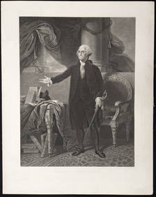
George Washington. 5 prints. 19th century. To include: 1) Large engraved portrait after StuartTremont Auctions4.6(293)See Sold PriceFeb 25, 2024
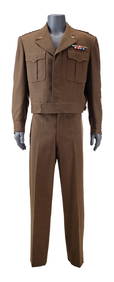
A rare and important carved fairground carousel mount torso by C J Spooner,Sworders Fine Art Auctioneers4.4(30)See Sold PriceMar 07, 2024
Three Mount Hope Mineral Railroad Company Annual Passes - 1901, 1903, and 1904Rail & Road Auctions4.6(165)See Sold PriceMar 08, 2024
The Columbian World's Fair Atlas 1892 / 1918 WW I Scrap Book Christian Herald Paper Clips Glued InNorth American Artifact Auctions4.6(182)See Sold PriceApr 20, 2024
[CIVIL WAR]. A group of engravings presenting scenes and subjects mostly related to enslavement andFreeman's | Hindman4.4(1.6k)See Sold PriceFeb 27, 2024
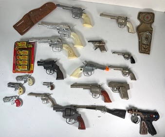
Lot of 20 1950s-1970s Various Sized Cap Guns, Holsters & 1 4pk Roll CapsJC Auctions4.4(47)See Sold PriceFeb 27, 2024
PATTON (1970) - General George Patton's (George C. Scott) Military UniformPropstore4.2(6)See Sold PriceMar 12, 2024
Trade Union Interest: a quantity of assorted badges, pins, etc. to include three Transport & GeneralClaydon Auctioneers Ltd4.3(125)See Sold PriceFeb 25, 2024
1816 MAP SOUTHERN PART OF RUSSIA or MUSCOVY in EUROPE copper engraving ANTIQUEJasper524.5(9.8k)See Sold PriceFeb 27, 2024
1816 MAP NORTHERN PART OF RUSSIA or MUSCOVY in EUROPE copper engraving ANTIQUEJasper524.5(9.8k)See Sold PriceFeb 27, 2024
West Indies Islands. Guadaloupe. | Mariegalante &C. | Antigua.Jasper524.5(9.8k)See Sold PriceFeb 27, 2024
THE WHOLE CHRONICLE OF POLYBIUS ANCIENT IN ENGLISH, 1756NY Elizabeth 4.3(84)See Sold PriceMar 03, 2024
Elements of General Knowledge by C & J Rivington London 1825Passion For Antiques3.9(23)See Sold PriceMar 10, 2024


![[JOHN THOMPSON'S A NEW GENERAL ATLAS] 45 Maps (1 of 4)](https://p1.liveauctioneers.com/1124/187577/94368896_1_x.jpg?height=282&quality=70&version=1607095126)


![WILLIAMS, C. S.; and [MELISH, J. G.] A New Gen (1 of 1)](https://p1.liveauctioneers.com/199/8400/1502886_1_x.jpg?height=282&quality=70)


![[CIVIL WAR]. A group of engravings presenting scenes and subjects mostly related to enslavement and (1 of 11)](https://p1.liveauctioneers.com/197/319238/171468105_1_x.jpg?height=282&quality=70&version=1707520367)