Marc Chagall-Limited Edition -Paris Opera Ceiling after ChagallArt Legacy Auctions4.5(217)See Sold PriceFeb 24, 2024
Salvador Dali Pantagruel Limited Edition Lithograph Hand signed and numberedArt Legacy Auctions4.5(217)See Sold PriceFeb 24, 2024
Pablo Picasso Bouquet of Peace Collection Domaine Picasso Limited Edition on paper.Art Legacy Auctions4.5(217)See Sold PriceFeb 24, 2024
A RARE MAXFIELD PARRISH JACK AND THE BEANSTALK PRINTSoulis Auctions4.8(953)See Sold PriceFeb 24, 2024
LARGE MECHANICAL PRINT 'STARS' AFTER MAXFIELD PARRISHSoulis Auctions4.8(953)See Sold PriceFeb 24, 2024
Heinrich Aldegrever, etc. 15 old master prints. 16th-17th centuries. Aldegrever works include "ManTremont Auctions4.6(293)See Sold PriceFeb 25, 2024
Sold1864 Map of PalestineAuthor: Mitchell Title: 1864 Map of Palestine Medium: Ink on Paper Dimensions: 12.5"X15.5" Description: Map of Palestine dated 1864. Published by Augustus Mitchell in Philadelphia. Elaborate border. CSee Sold Price
Sold1864 Map of PalestineAuthor: Johnson Title: 1864 Map of Palestine Medium: Ink on Paper Dimensions: 14.5"X18" Map of Palestine dated 1864. Engraved by A.J.Johnson. Published by Johnson and Ward in New York. Map key locatedSee Sold Price
Mitchell: Antique Map of Palestine, 18641864 hand-colored map of Palestine by S. Augustus Mitchell. A beautiful example of S. A. Mitchell Jr.'s 1864 map of Palestine, Israel or the Holy Land. Updated from the 1860 variant with new details,See Sold Price
Sold1864 hand-colored map of Palestine by S. AugustusA beautiful example of S. A. Mitchell Jr.'s 1864 map of Palestine, Israel or the Holy Land. Updated from the 1860 variant with new details, an inset of Jerusalem, and a new 1864 copyright. Includes boSee Sold Price
SoldJohnson's Map of Palestine, Inset of Jerusalem, 1864Map: Johnson's Map of Palestine, Inset of Jerusalem Publisher: Johnson and Ward Date: 1864 Size: 14 x 18 inches Please note that this lot has a reserve. When you leave a bid in advance of the auction,See Sold Price
Sold4 Vols. CHRISTIANITY Palestine Greece AngusThis auction lot includes the following group of titles: - Sermons on Syria, Palestine, and Greece by Smith - Dated 1864 by Spottiswoode & Co. - Maps - Religious Quests of the Graeco-Roman World bSee Sold Price
SoldMaps from the Ordnance Survey of Palestine by Wilson,A portfolio of maps, being the second part of the "Ordnance Survey of Palestine" conducted by Captain Charles William Wilson (1836-1905), in 1864. Contains five folding, cloth-backed maps, including tSee Sold Price
SoldANTIQUE MAP "PALESTINE"By Johnson and Ward. With hand coloring. Dimensions: (Frame) H 21.5" x W 17", (Sight) H 16" x W 12.75" Condition: Toning. Handling wear including rubs to frame.See Sold Price
SoldToms & Cellarius 1789 Map. Palestine, Israel"Palaestina sev Terra Sancta" Copper Engraved Map Published 1789, London for "Geographia Antiqua" Engraved W. H. Toms after an earlier map by Christoph Cellarius. Centre fold as published. Paper Size:See Sold Price
Sold1887 Hand Colored Map Palestine & Environs of Jerusalem1887 Hand Colored Engraving "Map of Palestine" with an inset of the "Environs of Jerusalem"Signed in plate: Bradley 1887Size: Approximately 8 1/4" x 11 1/4"Condition: A fSee Sold Price
Sold1864 Map of New York Railroads"Map of the Rail Roads of the State of New York prepared under the direction of William B Taylor...". S. H. Sweet , deputy state engineer and surveyor. Printed by C. Van Benthuysen, Albany. Printed wiSee Sold Price
Sold1864 MAP OF ENGLAND AND WALES BY A.J. JOHNSONProfessionally matted, 25.75 x 17.25 inch sight size.See Sold Price
1864 Map of Pennsylvania and New JerseryAuthor: Johnson Title: 1864 Map of Pennsylvania and New Jersery Materials: Ink on Paper Dimensions: 25.5"X18" Description: Map of Pennsylvania and New Jersey dated 1864. Engraved by A.J. Johnson. PublSee Sold Price
1864 Map of Massachussetts, Connecticut and RhodeAuthor: Johnson Title: 1864 Map of Massachussetts, Connecticut and Rhode Island Medium: Ink on Paper Dimensions: 26"X18" Map of Masschussetts, Connecticut and Rhode Island dated 1864. Engraved by A.J.See Sold Price
1864 Map of Austria, Turkey and GreeceAuthor: Johnson Title: 1864 Map of Austria, Turkey and Greece Medium: Ink on Paper Dimensions: 26"X18" Map of Austria, Greece and Turkey in Europe dated 1864. Engraved by A.J.Johnson. Published by JohSee Sold Price
1864 map of Seneca County and Tiffin Ohio1864 map of Seneca County and Tiffin, Oh. – 55" X 59See Sold Price
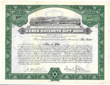
SoldPropaganda Poster URNA Map Palestine RefugeesOriginal vintage Map of URNA Areas of Operation - The Gaza Strip - Lebanon. Created in December 1949, the United Nations Relief and Works Agency for Palestine Refugees in the Near East (UNRWA) is a reSee Sold Price
1864 Map of Massachussetts, Connecticut and RhodeAuthor: Johnson Title: 1864 Map of Massachussetts, Connecticut and Rhode Island Medium: Ink on Paper Dimensions: 26"X18" Map of Masschussetts, Connecticut and Rhode Island dated 1864. Engraved by A.J.See Sold Price
Soldmap, Palestine, MaginiFramed hand colored engraved map of Palestine, ''Palaestina, Vel Terra Sancta,'' 18th century, after Giovanni Antonio Magini (Italian, 1555-1617), sight: 5.75''h x 7.25''w, overall: 15''h x 13''wSee Sold Price
1864 Map of Austria, Greece and TurkeyAuthor: Johnson Title: 1864 Map of Austria, Greece and Turkey Medium: Ink on Paper Dimensions: 26"X18" Description: Map of Austria, Greece and Turkey in Europe dated 1864. Engraved by A.J.Johnson. PubSee Sold Price
1864 Map of JapanAuthor: Johnson Title: 1864 Map of Japan Medium: Ink on Paper Dimensions: 17.5"X14" Description: Map of Japan dated 1864. Engraved by A.J.Johnson. Published by Johnson and Ward in New York. Key middleSee Sold Price
Sold1864 Map of Gold Lodes on the Comstock RangeWestern America“Map of Gold Hill Front Lodes on the Comstock Range” July 1864, “Map of Gold Hill Front Lodes on the Comstock Range”, Printed by Oakley & Tompson Lith., Boston,See Sold Price
SoldPropaganda Poster URNA Map Palestine RefugeesOriginal vintage Map of URNA Areas of Operation - The Gaza Strip - Lebanon. Created in December 1949, the United Nations Relief and Works Agency for Palestine Refugees in the Near East (UNRWA) is a reSee Sold Price
DAVID ROBERTS - Holy Land / Syria / Egypt etc. 3 x Folio Volumes 1849 Very RareLuis Porretta Fine Arts4.3(10)See Sold PriceMar 02, 2024
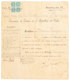
Jerusalem Map for British Soldiers in Palestine - WW2Levy Auction House4.3(11)See Sold PriceFeb 27, 2024
Proposed Sportsground Map - Haifa, Palestine - 1926Levy Auction House4.3(11)See Sold PriceFeb 27, 2024
Caravan Routes in Palestine Linen Map - Germany, 1881Levy Auction House4.3(11)See Sold PriceFeb 27, 2024
The Holy Land Tours - Hamburg American Line - 1911Levy Auction House4.3(11)See Sold PriceFeb 27, 2024
18 Booklets Collection - War Graves of Palestine - WWILevy Auction House4.3(11)See Sold PriceFeb 27, 2024
Illustrated Sabbath Cloth - Holy Sites of Eretz IsraelLevy Auction House4.3(11)See Sold PriceFeb 27, 2024
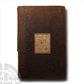
Numismatic Books - Whelan - The Numismatic Atlas of the Roman EmpireTimeLine Auctions Ltd.4.5(183)See Sold PriceMar 09, 2024
Numismatic Books - Whelan - The Numismatic Atlas of the Roman EmpireTimeLine Auctions Ltd.4.5(183)See Sold PriceMar 09, 2024
Civil War Map, Positions of the Army of the Ohio Front oh Dalton GA Dated 1864 34"L x 24"TSwisher Bros. Auction LLC4.4(241)See Sold PriceFeb 24, 2024
Civil War Map, Positions of the 16th Army Corps Dated 1864 34"L x 24"TSwisher Bros. Auction LLC4.4(241)See Sold PriceFeb 24, 2024