ATLAS of ANTIENT GEOGRAPHY by SAMUEL BUTLER 1843John McInnis Auctioneers,LLC4.6(502)See Sold PriceFeb 24, 2024
18TH C. ANTIQUE MAP: FRENCH & INDIAN WAR, FRAMEDThomaston Place Auction Galleries4.4(386)See Sold PriceFeb 24, 2024
Rand McNally Railroad Map Cabinet w/ 21 Railroad MapsRail & Road Auctions4.6(165)See Sold PriceMar 08, 2024
Keith Haring - Ink on New York Map, Best Buddies, Inscribed, Signed, and DatedSapphire Auction Gallery4(67)See Sold PriceMar 02, 2024
LATE 17TH C. FRENCH MAP OF THE NEW WORLD BY ALEXIS-HUBERT JAILLOT (1632-1712)Thomaston Place Auction Galleries4.4(386)See Sold PriceFeb 24, 2024
Central Railroad of New Jersey Map of Sandy Hook Route-ca. 1903JM Hobby Supply and Railroad Artifact Auctions4.4(126)See Sold PriceFeb 24, 2024
Lot of Six Mixed Atlas Box Cars-HO Scale-New in BoxJM Hobby Supply and Railroad Artifact Auctions4.4(126)See Sold PriceFeb 25, 2024
Rand McNally/Santa Fe Railroad Map of Iowa-1912JM Hobby Supply and Railroad Artifact Auctions4.4(126)See Sold PriceFeb 24, 2024
NICOLAES VISSCHER (NETHERLANDS, 1618-1709) MAP OF THE NEW WORLDThomaston Place Auction Galleries4.4(386)See Sold PriceFeb 24, 2024
17TH C. WORLD MAP BY NICOLAES VISSCHER (NETHERLANDS, 1618-1709)Thomaston Place Auction Galleries4.4(386)See Sold PriceFeb 24, 2024
Lot of Six Mixed Atlas Cabooses-HO Scale-New in BoxJM Hobby Supply and Railroad Artifact Auctions4.4(126)See Sold PriceFeb 25, 2024
SoldIndian Races of North & South America 1854This is a RARE early edition of "The Indian Races of North and South America" by Charles De Wolf Brownell published in 1854. The book provides an intriguing description of Native American Indians in tSee Sold Price
Nicholas de Fer: Map of North & South America, 1705Nicholas de Fer: L'Amerique, 1705, (first state), printed area is approximately 9" x 13" with wide margins. This is de Fer's reduced version of his wall map of America. It features California as an isSee Sold Price
SoldOrtelius: Antique Map of North & South America, 1598Map: America sive Novus Orbis Date Printed: 1598 Cartographer: Abraham Ortelius Size: 4 x 3 Condition: Good condition. A few brown thumbprints and one repaired marginal tear at the Northwest coast ofSee Sold Price
Homann: Antique Map of North & South America, 1740Map: Totius Americae Septentrionalis et Meridionalis Novissima Repraesentatio quam ex singulus recentium Geographorum Tabulis collecta luci publicae accomodavit Cartographer: HOMANN, Johannes BaptistaSee Sold Price
Sold1862 North & South America Illustrated Voyages Indians1862 North & South America Illustrated Voyages Indians Civil War Expeditions 2v Henry Howard Brownell was an American historian who gained his fame and prominence from his collection of Poems publisheSee Sold Price
SoldHomann Heirs: Antique Map of North & South America 1746Title/Content of Map: Americae mappa generalis Date Printed: 1746 Cartographer: Homann Heirs Material/Medium: Paper Size: 23 1/2" x 21" Hand colored copperplate engraved. Published in Nuremberg. Map hSee Sold Price
Ortelius: Antique Map of North & South America, 1598Map: America sive Novus Orbis Subtitle: America sive Novus Orbis Creator: Ortelius, Abraham Year: 1598 Condition: A few brown thumbprints and one repaired marginal tear at the Northwest coast of NorthSee Sold Price
SoldBlaeu map of North & South AmericaHeading: Author: Blaeu, Willem Title: Americae Nova Tabula Place Published: Amsterdam Publisher: Date Published: c.1633 Description: Copper-engraved map. 36x46.5 (14¼x18¼")See Sold Price
Sold(2) JOHN TALLIS ATLAS MAPS NORTH & SOUTH AMERICA(lot of 2) Framed hand-colored engravings on paper, maps of North and South America, mid 19th c., published in John Tallis's "Illustrated Atlas," drawn and engraved by John Rapkin, with illustrated viSee Sold Price
SoldIndian Races of North & South America Book by BrownellAmerican. 1861. The Indian Races of North & South America Book by Charles De Wolf Brownell. Front cover personalized to "M. & M. McIntyre" in gold script. 9 x 6 x 3". Front cover, detached at spine, hSee Sold Price
SoldThomson's map of North & South America 1813Heading: (Maps) Author: Thomson, John Title: America Place Published: London Publisher: Date Published: 1813 Description: Engraved map, hand-colored. 46x51.5 cm (18x20¼").</See Sold Price
de la Tour: Antique Map of North & South America, 1771Title/Content of Map: 'L'Amérique Dressée pour l'étude de la Géographie, revue et augmentée par Mr. Brion Ingénieur Géographe du Roy, à Paris, chez Desnos, Ingr. Géog. pour les Globes et SpheSee Sold Price
SoldNorth & South America in 1776 MapAuthor: Zantac, Antonio. L'America Divisa ne suoi Principali Stati di Nuova Projezione. Published inc Venice in 1776. Overall with frame 16" high x 20-1/4" wide. On laid paper with center crease withSee Sold Price
SoldTwo Small Map Engravings - North & South AmericaTwo Small Map Engravings - North & South America by Thomas Kitchen circa 1790 - 8 1/4" T X 7 1/2" WSee Sold Price
Sold[Map] De Fer, North & South America, 1717Nicolas de Fer - "L'Amerique, Meridionale et Septentrionale" (Paris: the Author, 1717) engraving, 9 X 13 1/4 in., plus margins (Interestingly, the only line of longitude is inscribed as passing over "See Sold Price
SoldNORTH & SOUTH AMERICA ILLUSTRATED - BROWNELLBrownell, Henry; "North and South America Illustrated from its First Discovery to the Present Administration Giving an Account of the Early Discoveries by the Northmen, Spaniards, Portuguese, French,See Sold Price
SoldMap of North & South America, 1805Charte von America. By von J. Walch, Augsburg. 1805. Size with Margin: 56 x 65 cm Please note that this lot has a confidential reserve. When you leave a bid in advance of the auction, submit your maxiSee Sold Price
SoldGROUP FRAMED MAPS INC. NORTH & SOUTH AMERICA, AFRICA &GROUP FRAMED MAPS INC. NORTH & SOUTH AMERICA, AFRICA & HUNGARY 18X16" LARGESTSee Sold Price
SoldIndian Races of North & South AmericaThe Indian Races of North and South America by Charles De Wolf Brownell with colored illustrations Published by subscription only New York at the American Subscription House. 1856.See Sold Price
de la Tour: Antique Map of North & South America, 1771Title/Content of Map: 'L'Amérique Dressée pour l'étude de la Géographie, revue et augmentée par Mr. Brion Ingénieur Géographe du Roy, à Paris, chez Desnos, Ingr. Géog. pour les Globes et SpheSee Sold Price
Thomson: Antique Map of North & South America, 1817Title/Content of Map: 'America' A large detailed map of the Americas, printed in 1817. Florida is coloured yellow in common with British Canada and the Bahamas, indicating British territory which hadSee Sold Price
Sold(3) MID 19TH CENTURY MAPS OF NORTH & SOUTH AMERICAStieler's Hand Atlas (1) von Stulpnagel 1853 map of South America with color highlights; (1) von Stulpnagel 1853 map of North and Central America with color highlights; (1) Justus Perthes, 1853 map ofSee Sold Price
SoldHall, Sidney 1852 Pair of Maps of North & South AmericaSteel Engraved Map Published 1852, London for "A Grammar of General Geography..." by the Rev. J. Goldsmith & Edward Hughes. Folds as issed. Maps by Sidney Hall. Paper Size: 8 x 6 inch (21 x 16cm) VerySee Sold Price
Renouard: Antique Map of North & South America, 1830No. VIII. Amérique, pour servir aux leçons de geographie de L'Abbé Gaultier' This scarce map of North America and South America by Jules Renouard shows Mexican Territory extending as far nortSee Sold Price
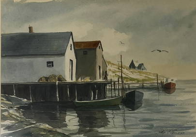
Al Barnes (1937-2015), A Meeting at the PointCopley Fine Art Auctions4.5(40)See Sold PriceFeb 24, 2024
LARGE EARLY 18TH C. DUTCH CHART OF UPPER NORTH AMERICA, PIERRE MORTIER (1661-1711), FRAMEDThomaston Place Auction Galleries4.4(386)See Sold PriceFeb 24, 2024
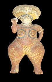
Large Human Effigy Pottery Vessel, Nicely Painted, Pre Columbian Pottery Vessle, South America. 14"Heartland Artifact Auctions Inc4.7(780)See Sold PriceFeb 25, 2024
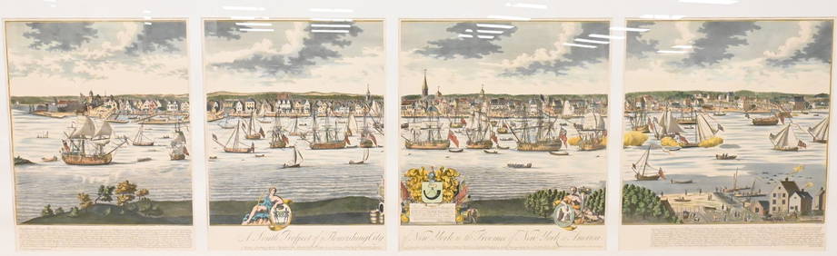
A South Prospect of Ye Flourishing City of New York in the Province of New York, North AmericaNadeau's Auction Gallery4.7(401)See Sold PriceFeb 24, 2024
The Rolling Stones Bridges To Babylon Tour Original Promotional PosterShakespeare Auctions4.3(1)See Sold PriceFeb 25, 2024
4 3/16" Ancient Inca Stone Mace. South America. Motley COATony Putty Artifacts4.7(404)See Sold PriceMar 09, 2024
Carey, pub. 1796 - Map of the Tennassee State formerly part of North Carolina (Tennessee)Trillium Antique Prints & Rare Books4.5(30)See Sold PriceFeb 24, 2024
Map: An 18thC engraved and hand coloured map of North America and South America, titled DeClaydon Auctioneers Ltd4.3(125)See Sold PriceFeb 26, 2024
1822 MAP of NORTH & SOUTH AMERICA GEOGRAPHICAL STATISTICAL HISTORICAL antiqueJasper524.5(9.8k)See Sold PriceFeb 27, 2024
5" Olmec God Effigy Pre-Colombian Pendant, South AmericaHeartland Artifact Auctions Inc4.7(780)See Sold PriceMar 10, 2024
Mexico, Central America and West Indies Physical PoliticalJasper524.5(9.8k)See Sold PriceFeb 27, 2024
Large Fossilized Tortoise Shell - Stylemys NebraskensisArtemis Fine Arts4.8(1.4k)See Sold PriceMar 01, 2024


![[Map] De Fer, North & South America, 1717 (1 of 1)](https://p1.liveauctioneers.com/523/81971/42494504_1_x.jpg?height=282&quality=70&version=1447274451)