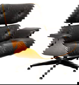
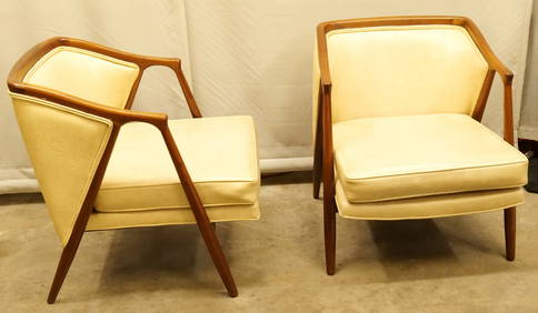
Charles & Ray Eames for Herman Miller Lounge ChairAuctions at Showplace4.5(726)See Sold PriceMar 03, 2024
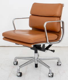
Eames for Herman Miller Executive Soft Pad ChairAuctions at Showplace4.5(726)See Sold PriceMar 03, 2024
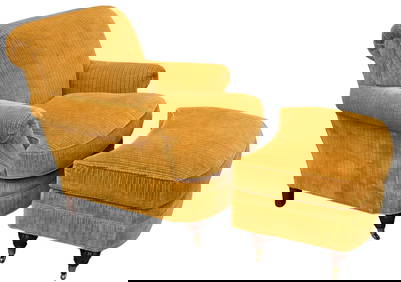
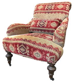
Lewis Mittman Upholstered Club Chair and OttomanNadeau's Auction Gallery4.7(401)See Sold PriceFeb 24, 2024
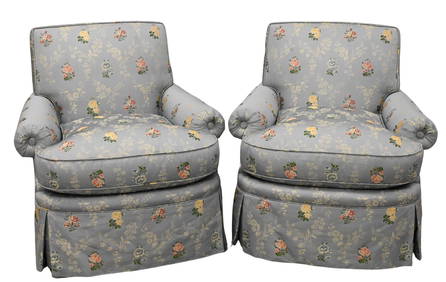
Chintz Tufted Upholstered Club Chair with a Matching Slipper Chair, Designed by Mario BuattaSTAIR4.6(286)See Sold PriceMar 06, 2024
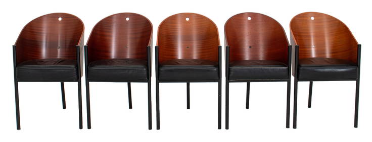
Philippe Starck x Aleph "Costes" Sapele Chairs, 5Auctions at Showplace4.5(726)See Sold PriceMar 03, 2024
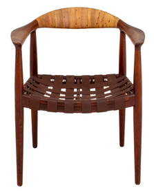
Hans Wegner for J. Hansen JH-501 Teak Arm ChairAuctions at Showplace4.5(726)See Sold PriceMar 03, 2024
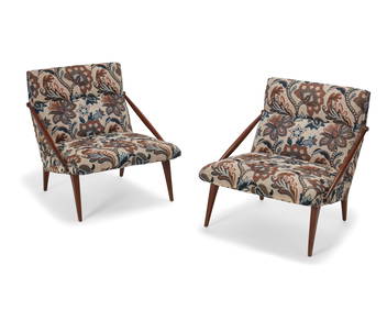
Pair of Lewis Mittman Incorporated Custom Upholstered Swivel ArmchairsNadeau's Auction Gallery4.7(401)See Sold PriceFeb 24, 2024
Pair of Mid Century Modern Barrel back ArmchairsBodnar's Auction Sales4.6(609)See Sold PriceMar 06, 2024
A pair of Gio Ponti for M. Singer and Sons lounge chairsJohn Moran Auctioneers, Inc.4.7(453)See Sold PriceFeb 27, 2024
MAP, Southern South America, AnsonSouthern South America. George Anson, Carte de la Partie Meridionale de l'Amerique Meridionale avec la Route du Centurion Depuis l'Ile Ste. Catherine Jusqu'a l'Ile de Juan Fernandes..., 1787 (circa).See Sold Price
MAP, Southern South America, AnsonSouthern South America. George Anson, Carte de la Partie Meridionale de l'Amerique Meridionale avec la Route du Centurion, Depuis l'Ile Ste. Catherine..., from Voyage Autour du Monde..., 1770 (circa).See Sold Price
SoldAnson (George) - A Voyage round the World, in the yearsninth edition, engraved frontispiece and 42 plates and maps, mostly folding, 1 chart of Southern South America (torn), 1 chart of the Channel in the Philippine Islands (torn with some tape repairs toSee Sold Price
1756 Southern South America, N.E. of Terra Del Fuego at Le Maire Waterway, by G. AnsonTitle: 1756 Southern South America, N.E. of Terra Del Fuego at Le Maire Waterway, by G. Anson Date/Period: 1756 Materials: Copper plate engraved Size: 20 1/2” x 11 ” This 1756 map portraysSee Sold Price
Anson (George) & Seale (Richard William) A Chart of theAnson (George) & Seale (Richard William) A Chart of the Southern Part of South America…, copper engraved map, hand coloured, from Anson’s ‘A Voyage Round the World’, fold lines, two holes alonSee Sold Price
[TRAVELS] Anson, A voyage round the worldAnson George, A voyage round the world, in the Years MDCCXL, I, II, III, IV [...] with Charts of the Southern Part of South America, of Part of the Pacific Ocean... London: printed for H. WoodfalSee Sold Price
Santini / d'Anville: Antique Map Southern South AmericaTitle/Content of Map: 'Carte de Chili Méridional, du Rio de la Plata, des Patagons, et du Détroit de Magellan; Ce qui fait l'extremité Australe de l'Amérique Méridle. par le Sr. d'Anville. À VenSee Sold Price
MAP, Southern South America, D'AnvilleSouthern South America. D'Anville/Santini, Carte du Chili Meridional, du Rio de la Plata, des Patagons, et du Detroit de Magellan; ce qui suit l'Extremite Australe de l'Amerique Meridle., from Atlas USee Sold Price
MAP, Southern South America, ZattaSouthern South America. Antonio Zatta, Il Chili lo Stretto Magellanico coll' Isola della Terra del Fuoco, 1794 (dated). Hand Color. This finely engraved copper plate map covers Chili and Argentina froSee Sold Price
MAP - Southern South America. CookSouthern South America. Capt. James Cook, A Chart of the Southern Extremity of America, 1775 (dated). Hand Color. This is the first state of this interesting copper-engraved sea chart that was publishSee Sold Price
MAP - Southern South America. Capt. CookSouthern South America. Capt. James Cook, A Chart of the Southern Extremity of America, 1777 (dated). Hand Color. This interesting copper-engraved sea chart was published by William Strahan and ThomasSee Sold Price
MAP, Southern South America, SansonSouthern South America. N. Sanson/Mariette, Le Paraguayr. Le Chili. La Terre, et les Isles Magellanicques. Tirees de Diverses Relations, 1656 (dated). Hand Color. Superb map of the southern part of thSee Sold Price
MAP - Southern South America. MollSouthern South America. Herman Moll, Chili Magellans-Land and Terra del Fuego &c., 1701 (published). Hand Color. This detailed copper engraved map shows the southern tip of South America with Tierra dSee Sold Price
MAP - Southern South America. De LaetSouthern South America. Joannes de Laet, Provinciae Sitae ad Fretum Magallanis Itemque Fretum Le Maire, 1630 (circa). Hand Color. This fine map is the work of Hessel Gerritsz, one of the most importanSee Sold Price
SoldHomann map of southern South America 1733Title: Typus Geographicus Chili a Paraguay, Freti Magellanici &c. ... Author: Homann Heirs Description: Copper-engraved map, hand-colored; uncolored pictorial cartouche. 48x56 cm. (19x22").Paraguay, USee Sold Price
Morse & Gaston Map of Southern South AmericaMORSE, Sidney & GASTON, Samuel. Brazil, Bolivia, La Plata, Paraguay, Uruguay, Chili, and part of Peru. Lithographed map with original hand color. New York, 1856. 7 1/4" x 6 1/4" sheet.See Sold Price
SoldGrp: 7 Maps of South AmericaGroup of seven maps of South America. Includes three maps of the continent overall; one map of North and South America; two maps of southern South America, depicting Chile, Argentina, Uruguay, and BolSee Sold Price
SoldChatelain: Carte Paraguai Chili Detroit Magellan, 1719Map: Carte du Paraguai, du Chili, du Detroit de Magellan Cartographer: Chatelain Place & Date: Amsterdam / 1719 Size: 20 1/4" x 15 3/4" Chatelain's superbly detailed map of southern South America exteSee Sold Price
SoldBowen: Map of Chili, Terra Magellanica, Terra del FuegoMap: A New and Accurate Map of Chili, Terra Magellanica. Terra del Fuego Cartographer: Bowen Place & Date: London / 1750 Size: 16 7/8" x 14" Bowen's wonderfully detailed map of southern South AmericaSee Sold Price
A New and Accurate Map of Chili, Bowen, 1750Bowen's wonderfully detailed map of southern South America from his A Complete System of Geography. Includes an inset map of Tierra del Fuego and a plan of Santiago, capital of Chile. Cartographer: BoSee Sold Price
SoldBlaeu (Willem) Tabula MagellanicaBlaeu (Willem) Tabula Magellanica qua Tierrae del Fuego, engraved map of southern South America, decorative cartouche and numerous galleons in full sail, with hand-colouring, 415 x 535mm., FreSee Sold Price
Sold[Hondius (Henricus)] Freti Magellanici[Hondius (Henricus)] Freti Magellanici ac novi Freti vulgo Le Maire exactissima delineatio, engraved map of southern South America showing the Magellan Straits, part of Tierra del Fuego, penguSee Sold Price
Southern States of South America. La Plata, Chili,Title/Content of Map: Southern States of South America. La Plata, Chili, Paraguay, Uruguay & Patagonia. Date Printed: 1865 ca. Cartographer: LOWRY, J. W.] Size: 23.75X16.75 Two conjugate sheets, unjoiSee Sold Price
Southern States of South America.Title/Content of Map: Southern States of South America. Date Printed: 1875 Cartographer: LOWRY, JOSEPH WILSON Size: 23.8X16.8 "La Plata, Chili, Paraguay, Uruguay & Patagonia. By J. W. Lowry, F.R.G.S."See Sold Price
Carey, pub. 1796 - A Chart of the West IndiesTrillium Antique Prints & Rare Books4.5(30)See Sold PriceFeb 24, 2024
Carey, pub. 1796 - Map of the State of MarylandTrillium Antique Prints & Rare Books4.5(30)See Sold PriceFeb 24, 2024
Carey, pub. 1796 - Map of GeorgiaTrillium Antique Prints & Rare Books4.5(30)See Sold PriceFeb 24, 2024
Carey, pub. 1796 - Map of The State of South CarolinaTrillium Antique Prints & Rare Books4.5(30)See Sold PriceFeb 24, 2024
Carey, pub. 1796 - Map of KentuckyTrillium Antique Prints & Rare Books4.5(30)See Sold PriceFeb 24, 2024
Carey, pub. 1796 - Map of the Tennassee State formerly part of North Carolina (Tennessee)Trillium Antique Prints & Rare Books4.5(30)See Sold PriceFeb 24, 2024
Map: A 19thC engraved and hand coloured map of South America. Published by the Society for theClaydon Auctioneers Ltd4.3(125)See Sold PriceFeb 26, 2024
Map: An 18thC engraved and hand coloured map of North America and South America, titled DeClaydon Auctioneers Ltd4.3(125)See Sold PriceFeb 26, 2024
1822 MAP of SOUTH AMERICA GEOGRAPHICAL STATISTICAL HISTORICAL antique 17.5x 22"Jasper524.5(9.8k)See Sold PriceFeb 27, 2024
1822 MAP of NORTH & SOUTH AMERICA GEOGRAPHICAL STATISTICAL HISTORICAL antiqueJasper524.5(9.8k)See Sold PriceFeb 27, 2024
1683 Sanson Map of the Caribbean -- Les Isles Antilles, &c Entre Lesquelles sont les Lucayes, et lesJasper524.5(9.8k)See Sold PriceFeb 27, 2024
Mexico, Central America and West Indies Physical PoliticalJasper524.5(9.8k)See Sold PriceFeb 27, 2024


![[TRAVELS] Anson, A voyage round the world (1 of 3)](https://p1.liveauctioneers.com/1306/165899/83732057_1_x.jpg?height=282&quality=70&version=1586937270)


![[Hondius (Henricus)] Freti Magellanici (1 of 1)](https://p1.liveauctioneers.com/410/3027/1300321_1_x.jpg?height=282&quality=70)


